
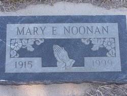
Mary Eleanor Rohan Noonan
| Birth | : | 1 Mar 1915 Spalding, Greeley County, Nebraska, USA |
| Death | : | 31 Oct 1999 Spalding, Greeley County, Nebraska, USA |
| Burial | : | Market Harborough Cemetery, Market Harborough, Harborough District, England |
| Coordinate | : | 52.4684000, -0.9132760 |
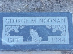
| Description | : | Daughter of John & Elizabeth (Murphy) Rohan. Married to George Noonan on 6-4-1940 at Spalding, NE. |
frequently asked questions (FAQ):
-
Where is Mary Eleanor Rohan Noonan's memorial?
Mary Eleanor Rohan Noonan's memorial is located at: Market Harborough Cemetery, Market Harborough, Harborough District, England.
-
When did Mary Eleanor Rohan Noonan death?
Mary Eleanor Rohan Noonan death on 31 Oct 1999 in Spalding, Greeley County, Nebraska, USA
-
Where are the coordinates of the Mary Eleanor Rohan Noonan's memorial?
Latitude: 52.4684000
Longitude: -0.9132760
Family Members:
Parent

Spouse
Siblings
Flowers:


Nearby Cemetories:
1. Market Harborough Cemetery
Market Harborough, Harborough District, England
Coordinate: 52.4684000, -0.9132760
2. St. Nicholas Churchyard
Little Bowden, Harborough District, England
Coordinate: 52.4754180, -0.9114670
3. St Dionysius Parish Church
Market Harborough, Harborough District, England
Coordinate: 52.4785850, -0.9213720
4. St. Mary in Arden Churchyard
Market Harborough, Harborough District, England
Coordinate: 52.4804240, -0.9110140
5. Saint Helen's Churchyard
Great Oxendon, Daventry District, England
Coordinate: 52.4484500, -0.9191000
6. Saint John the Baptist Churchyard
East Farndon, Daventry District, England
Coordinate: 52.4562100, -0.9472400
7. Great Bowden Cemetery
Great Bowden, Harborough District, England
Coordinate: 52.4916800, -0.8995200
8. All Saints Churchyard
Braybrooke, Kettering Borough, England
Coordinate: 52.4538160, -0.8764390
9. All Saints Churchyard
Dingley, Kettering Borough, England
Coordinate: 52.4817700, -0.8682200
10. All Saints Churchyard
Lubenham, Harborough District, England
Coordinate: 52.4770020, -0.9631870
11. St. Nicholas' Churchyard
Marston Trussell, Daventry District, England
Coordinate: 52.4669200, -0.9804650
12. St Andrew Churchyard
Arthingworth, Daventry District, England
Coordinate: 52.4255400, -0.8914700
13. St. Mary's Churchyard
Brampton Ash, Kettering Borough, England
Coordinate: 52.4796000, -0.8402000
14. St Mary the Virgin Churchyard
Brampton, Kettering Borough, England
Coordinate: 52.4797580, -0.8400370
15. All Saints Churchyard
Clipston, Daventry District, England
Coordinate: 52.4273400, -0.9517300
16. Baptist Graveyard
Clipston, Daventry District, England
Coordinate: 52.4296989, -0.9582000
17. Foxton Cemetery
Foxton, Harborough District, England
Coordinate: 52.4998900, -0.9734000
18. St Andrew Churchyard
Foxton, Harborough District, England
Coordinate: 52.5011100, -0.9716680
19. Thorpe Langton, St Leonard's Churchyard
Thorpe Langton, Harborough District, England
Coordinate: 52.5247101, -0.9104123
20. St. Helen's Churchyard
Sibbertoft, Daventry District, England
Coordinate: 52.4386400, -0.9989200
21. St Andrew's Churchyard
Welham, Harborough District, England
Coordinate: 52.5246240, -0.8733420
22. St Botolph Churchyard
Stoke Albany, Kettering Borough, England
Coordinate: 52.4865500, -0.8151720
23. St. Deny's Churchyard
Kelmarsh, Daventry District, England
Coordinate: 52.4060590, -0.9207120
24. St Giles Churchyard
Desborough, Kettering Borough, England
Coordinate: 52.4398300, -0.8202300