

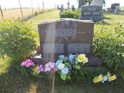
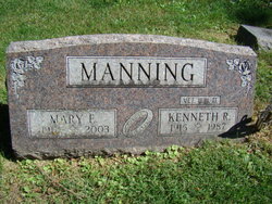
Mary Eliza “Elizabeth” Dougherty Manning
| Birth | : | 24 Jun 1912 Henry County, Iowa, USA |
| Death | : | 21 Nov 2003 Mesa, Maricopa County, Arizona, USA |
| Burial | : | Mount Pleasant Cemetery, LeRoy, Dodge County, USA |
| Coordinate | : | 43.6167800, -88.5263000 |
| Plot | : | 3rd.188 |
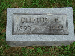
| Description | : | STRONG CAUTION UPDATE: recent information and checking of cemetery records leave considerable doubt about where Mary was buried. Evergreen cemetery records do NOT show her burial in this lot with Kenneth Raymond Manning, despite the headstone engraving that implies burial. Also , her maiden name was Dougherty. She was previously married to Clifton Henry Israel and she used the Israel surname when she married Kenneth, causing the inadvertent use of Israel as the maiden name in certain cemetery transcriptions. No Fairfield obituary has been found; a Arizona Republic newpaper item published on Nov. 25, 2003 only mentions her... Read More |
frequently asked questions (FAQ):
-
Where is Mary Eliza “Elizabeth” Dougherty Manning's memorial?
Mary Eliza “Elizabeth” Dougherty Manning's memorial is located at: Mount Pleasant Cemetery, LeRoy, Dodge County, USA.
-
When did Mary Eliza “Elizabeth” Dougherty Manning death?
Mary Eliza “Elizabeth” Dougherty Manning death on 21 Nov 2003 in Mesa, Maricopa County, Arizona, USA
-
Where are the coordinates of the Mary Eliza “Elizabeth” Dougherty Manning's memorial?
Latitude: 43.6167800
Longitude: -88.5263000
Family Members:
Parent

Spouse
Siblings
Flowers:


Nearby Cemetories:
1. Mount Pleasant Cemetery
LeRoy, Dodge County, USA
Coordinate: 43.6167800, -88.5263000
2. Brownsville Community Cemetery
Brownsville, Dodge County, USA
Coordinate: 43.5995380, -88.5053440
3. Mount Pleasant Cemetery
Oakfield, Fond du Lac County, USA
Coordinate: 43.6391983, -88.5460968
4. Saint Pauls Evangelical Lutheran Cemetery
Brownsville, Dodge County, USA
Coordinate: 43.6167200, -88.4889100
5. Emanuel Cemetery
Knowles, Dodge County, USA
Coordinate: 43.5877991, -88.4997025
6. Saint Andrews Church Cemetery
LeRoy, Dodge County, USA
Coordinate: 43.5732994, -88.5500336
7. Genesee Cemetery
Byron, Fond du Lac County, USA
Coordinate: 43.6613884, -88.5066681
8. Miles Farm Cemetery
LeRoy, Dodge County, USA
Coordinate: 43.6251880, -88.5917650
9. Saint Luke Evangelical Lutheran Church Cemetery
Knowles, Dodge County, USA
Coordinate: 43.5718720, -88.5016540
10. Old Community Cemetery
Lomira, Dodge County, USA
Coordinate: 43.6086590, -88.4499060
11. Saint Marys Cemetery
Lomira, Dodge County, USA
Coordinate: 43.5903015, -88.4518967
12. Oak Center Cemetery
Oak Center, Fond du Lac County, USA
Coordinate: 43.6466600, -88.6009400
13. Saint Johns Lutheran Cemetery
Lomira, Dodge County, USA
Coordinate: 43.5877266, -88.4469833
14. Salem Cemetery
Lomira, Dodge County, USA
Coordinate: 43.5872530, -88.4463790
15. Byron Cemetery
Byron, Fond du Lac County, USA
Coordinate: 43.6572189, -88.4505615
16. Avoca Cemetery
Oakfield, Fond du Lac County, USA
Coordinate: 43.6872215, -88.5319366
17. Ebenezer Cemetery
Lomira, Dodge County, USA
Coordinate: 43.6156006, -88.4210968
18. Tidyman Cemetery
LeRoy, Dodge County, USA
Coordinate: 43.5482370, -88.5810470
19. Saint John Catholic Cemetery
Byron, Fond du Lac County, USA
Coordinate: 43.6744400, -88.4501000
20. Saint Paul Cemetery
Kekoskee, Dodge County, USA
Coordinate: 43.5455310, -88.5809180
21. Saint Peters Cemetery
Theresa, Dodge County, USA
Coordinate: 43.5367012, -88.4794006
22. Saint Pauls Evangelical Lutheran Cemetery
Lomira, Dodge County, USA
Coordinate: 43.5510050, -88.4430740
23. Kekoskee Cemetery
Kekoskee, Dodge County, USA
Coordinate: 43.5263390, -88.5612850
24. Norwegian Evangelical Lutheran Cemetery
Waupun, Fond du Lac County, USA
Coordinate: 43.6458200, -88.6540000