
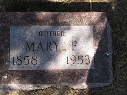
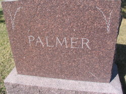


Mary Elmira Smith Palmer
| Birth | : | 19 Aug 1858 Stockholm, St. Lawrence County, New York, USA |
| Death | : | 29 Oct 1953 Mellette, Spink County, South Dakota, USA |
| Burial | : | Knowle Green Congregational Graveyard, Knowle Green, Ribble Valley Borough, England |
| Coordinate | : | 53.8380170, -2.5507210 |
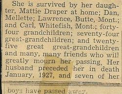
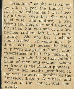
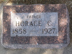
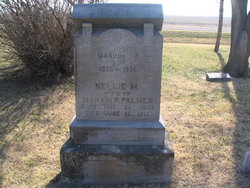
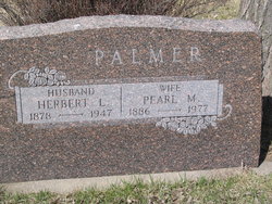
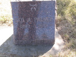
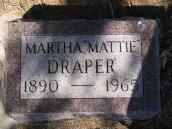
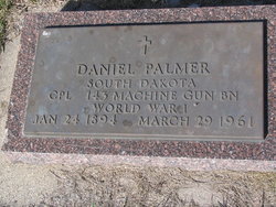
| Description | : | Mary Elmira Palmer died at the age of 95yrs. She married Horace C Palmer (s/o Platt and Mary Palmer) 15 Dec 1875 at Brasher Falls, NY. They homesteaded June 1881 in Spink Co, SD, north of Mellette. She was active in the American Legion Auxiliary and church affairs. Survivors are daughter Mattie Draper (Martha born 1890) of Mellette; sons Lawrence (1898) of Butte, Mt; Daniel (1894) of Mellette and Carl (1896)of Whitefish, Mt; 44 grandchildren; 74 great grandchildren and 25 great grandchildren. Her husband died in 1927 and seven sons (Marvin; Herbert; Irwin; George; Irl; Harrison; and... Read More |
frequently asked questions (FAQ):
-
Where is Mary Elmira Smith Palmer's memorial?
Mary Elmira Smith Palmer's memorial is located at: Knowle Green Congregational Graveyard, Knowle Green, Ribble Valley Borough, England.
-
When did Mary Elmira Smith Palmer death?
Mary Elmira Smith Palmer death on 29 Oct 1953 in Mellette, Spink County, South Dakota, USA
-
Where are the coordinates of the Mary Elmira Smith Palmer's memorial?
Latitude: 53.8380170
Longitude: -2.5507210
Family Members:
Parent
Spouse
Siblings
Children

Flowers:


Nearby Cemetories:
1. Knowle Green Congregational Graveyard
Knowle Green, Ribble Valley Borough, England
Coordinate: 53.8380170, -2.5507210
2. The Church of St. Saviour The Holy House of Stydd
Ribchester, Ribble Valley Borough, England
Coordinate: 53.8188690, -2.5272770
3. St William of York Churchyard
Thornley with Wheatley, Ribble Valley Borough, England
Coordinate: 53.8559540, -2.5866660
4. St Wilfrid Churchyard
Ribchester, Ribble Valley Borough, England
Coordinate: 53.8102780, -2.5332650
5. St Lawrence Churchyard
Longridge, Ribble Valley Borough, England
Coordinate: 53.8252470, -2.6015030
6. St Wilfred Roman Catholic Churchyard Cemetery
Longridge, Ribble Valley Borough, England
Coordinate: 53.8317380, -2.6086060
7. St John the Evangelist Churchyard
Hurst Green, Ribble Valley Borough, England
Coordinate: 53.8358000, -2.4852530
8. Stonyhurst College Burial Ground
Hurst Green, Ribble Valley Borough, England
Coordinate: 53.8403420, -2.4840310
9. St. Joseph Roman Catholic Churchyard
Hurst Green, Ribble Valley Borough, England
Coordinate: 53.8409900, -2.4820600
10. Our Lady and St. Michael Roman Catholic Churchyard
Longridge, Ribble Valley Borough, England
Coordinate: 53.8088040, -2.6133470
11. Chipping Congregational Churchyard
Chipping, Ribble Valley Borough, England
Coordinate: 53.8836000, -2.5777700
12. St. Bartholomew Churchyard
Chipping, Ribble Valley Borough, England
Coordinate: 53.8846800, -2.5764100
13. St Leonard Churchyard
Balderstone, Ribble Valley Borough, England
Coordinate: 53.7860070, -2.5609380
14. St Mary's R.C. Church Cemetery
Osbaldeston, Ribble Valley Borough, England
Coordinate: 53.7816970, -2.5350240
15. Brockhall Hospital Cemetery
Brockhall Village, Ribble Valley Borough, England
Coordinate: 53.8186850, -2.4560220
16. St. Leonard Old Churchyard
Langho, Ribble Valley Borough, England
Coordinate: 53.8178590, -2.4552870
17. St Peter Churchyard
Salesbury, Ribble Valley Borough, England
Coordinate: 53.7915000, -2.4859100
18. St. Michael's Churchyard
Grimsargh, City of Preston, England
Coordinate: 53.7990710, -2.6352530
19. Mellor Methodist Churchyard
Blackburn, Blackburn with Darwen Unitary Authority, England
Coordinate: 53.7742950, -2.5255060
20. St. Mary's Churchyard
Mellor, Ribble Valley Borough, England
Coordinate: 53.7728600, -2.5312400
21. Whittingham Hospital Cemetery
Goosnargh, City of Preston, England
Coordinate: 53.8208401, -2.6613468
22. All Hallows Churchyard
Great Mitton, Ribble Valley Borough, England
Coordinate: 53.8461500, -2.4339000
23. Preston Crematorium
Preston, City of Preston, England
Coordinate: 53.7863750, -2.6340170
24. St. Mary the Virgin Churchyard
Goosnargh, City of Preston, England
Coordinate: 53.8266470, -2.6707030