
| Memorials | : | 49 |
| Location | : | Preston, City of Preston, England |
| Phone | : | 01772 792391 |
| Website | : | www.remembrance-books.com/preston/book-of-remembrance.html#page/1 |
| Coordinate | : | 53.7863750, -2.6340170 |
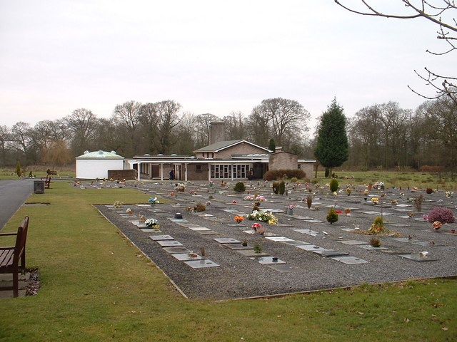
| Description | : | Preston Crematorium was opened in February 1962. At present it serves Preston and the surrounding area by carrying out approximately 1600 cremations per year. This crematorium has been equipped with computer operated cremators that are able to comply with the strict limits on pollutants laid down by the 1990 UK Environmental Protection Act. You can view the Book of Remembrance (at Preston Crematorium) from: 8.00 am – 4.00 pm Monday – Friday 12.00 noon – 3.45 pm Saturday, Sunday and Public Holidays |
frequently asked questions (FAQ):
-
Where is Preston Crematorium?
Preston Crematorium is located at Longridge Road Preston, City of Preston ,Lancashire , PR2 5BPEngland.
-
Preston Crematorium cemetery's updated grave count on graveviews.com?
0 memorials
-
Where are the coordinates of the Preston Crematorium?
Latitude: 53.7863750
Longitude: -2.6340170
Nearby Cemetories:
1. St. Michael's Churchyard
Grimsargh, City of Preston, England
Coordinate: 53.7990710, -2.6352530
2. St. Leonard the Less Churchyard
Samlesbury, South Ribble Borough, England
Coordinate: 53.7680000, -2.6237000
3. St. Mary's and St. John RC Churchyard, Southworth
Samlesbury, South Ribble Borough, England
Coordinate: 53.7676690, -2.6183400
4. Preston New Cemetery
Ribbleton, City of Preston, England
Coordinate: 53.7717400, -2.6620900
5. Preston Old Cemetery
Ribbleton, City of Preston, England
Coordinate: 53.7686352, -2.6623154
6. Our Lady and St. Michael Roman Catholic Churchyard
Longridge, Ribble Valley Borough, England
Coordinate: 53.8088040, -2.6133470
7. St. Mary's Churchyard
Preston, City of Preston, England
Coordinate: 53.8010830, -2.6779600
8. Whittingham Hospital Cemetery
Goosnargh, City of Preston, England
Coordinate: 53.8208401, -2.6613468
9. Christ Church Churchyard
Fulwood, City of Preston, England
Coordinate: 53.7771920, -2.7028700
10. St. Paul Churchyard
Preston, City of Preston, England
Coordinate: 53.7625360, -2.6947080
11. St Leonard Churchyard
Balderstone, Ribble Valley Borough, England
Coordinate: 53.7860070, -2.5609380
12. St Leonard Churchyard
Walton-le-Dale, South Ribble Borough, England
Coordinate: 53.7476530, -2.6666950
13. St Lawrence Churchyard
Longridge, Ribble Valley Borough, England
Coordinate: 53.8252470, -2.6015030
14. St. Ignatius RC Churchyard
Preston, City of Preston, England
Coordinate: 53.7635270, -2.6965870
15. St Augustine of Canterbury
Preston, City of Preston, England
Coordinate: 53.7560420, -2.6912650
16. St. Mary the Virgin Churchyard
Goosnargh, City of Preston, England
Coordinate: 53.8266470, -2.6707030
17. All Saints Churchyard
Walton-le-Dale, South Ribble Borough, England
Coordinate: 53.7407250, -2.6408280
18. Our Lady and St Patrick's Church
Walton-le-Dale, South Ribble Borough, England
Coordinate: 53.7407250, -2.6408280
19. St John Churchyard
Preston, City of Preston, England
Coordinate: 53.7582080, -2.6959750
20. St. James' Churchyard
Preston, City of Preston, England
Coordinate: 53.7566010, -2.6941110
21. St Wilfred Roman Catholic Churchyard Cemetery
Longridge, Ribble Valley Borough, England
Coordinate: 53.8317380, -2.6086060
22. Holy Trinity
Preston, City of Preston, England
Coordinate: 53.7613030, -2.7030580
23. Friends Meeting House Burial Ground (Defunct)
Preston, City of Preston, England
Coordinate: 53.7610250, -2.7030380
24. St. George the Martyr
Preston, City of Preston, England
Coordinate: 53.7591220, -2.7025660