
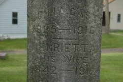
| Birth | : | 5 Jan 1845 Bedford County, Pennsylvania, USA |
| Death | : | 8 Apr 1935 Council Bluffs, Pottawattamie County, Iowa, USA |
| Burial | : | Walnut Hill Cemetery, Council Bluffs, Pottawattamie County, USA |
| Coordinate | : | 41.2719002, -95.8255997 |
| Plot | : | section 19, lot # 039, grave # 2 |
| Description | : | Funeral services for Mrs. Marietta Mosher will be held Wednesday at 4 p. m. at the Woodring chapel, with Rev. Paul H. Hicks of Epworth Methodist church officiating. Burial will be in Walnut Hill cemetery. source of funeral notice article: Council Bluffs Nonpareil (Council Bluffs, Iowa), evening edition, April 9, 1935, page 7, column 4 ************************************************************************************** Funeral services for Mrs. Marietta Mosher were held Wednesday at 4 p. m. at Woodring's chapel, with Rev. Paul Hicks officiating. Music was by Mrs. Ralph McCart, Mrs. Harry Stone and Harry Cox. Pallbearers were Lou Betts, A. J.... Read More |
frequently asked questions (FAQ):
-
Where is Mary Etta “Marietta” Gast Mosher's memorial?
Mary Etta “Marietta” Gast Mosher's memorial is located at: Walnut Hill Cemetery, Council Bluffs, Pottawattamie County, USA.
-
When did Mary Etta “Marietta” Gast Mosher death?
Mary Etta “Marietta” Gast Mosher death on 8 Apr 1935 in Council Bluffs, Pottawattamie County, Iowa, USA
-
Where are the coordinates of the Mary Etta “Marietta” Gast Mosher's memorial?
Latitude: 41.2719002
Longitude: -95.8255997
Family Members:
Parent

Spouse
Siblings
Flowers:


Nearby Cemetories:
1. Walnut Hill Cemetery
Council Bluffs, Pottawattamie County, USA
Coordinate: 41.2719002, -95.8255997
2. Bikhor Cholim Cemetery
Council Bluffs, Pottawattamie County, USA
Coordinate: 41.2703670, -95.8229350
3. Ridgewood Cemetery
Council Bluffs, Pottawattamie County, USA
Coordinate: 41.2694016, -95.8272018
4. Oak Hill Cemetery
Council Bluffs, Pottawattamie County, USA
Coordinate: 41.2700900, -95.8226400
5. Green Valley Cemetery
Council Bluffs, Pottawattamie County, USA
Coordinate: 41.2743988, -95.8225021
6. Saint Joseph Cemetery
Council Bluffs, Pottawattamie County, USA
Coordinate: 41.2722015, -95.8208008
7. Cedar Lawn Cemetery
Council Bluffs, Pottawattamie County, USA
Coordinate: 41.2694016, -95.8182983
8. Memorial Park Cemetery
Council Bluffs, Pottawattamie County, USA
Coordinate: 41.2644005, -95.8261032
9. Clark Cemetery
Pottawattamie County, USA
Coordinate: 41.2551610, -95.8223390
10. Fairview Cemetery
Council Bluffs, Pottawattamie County, USA
Coordinate: 41.2703018, -95.8480988
11. Garner Cemetery
Council Bluffs, Pottawattamie County, USA
Coordinate: 41.2956161, -95.8001709
12. Stoker-Graybill Cemetery
Council Bluffs, Pottawattamie County, USA
Coordinate: 41.2532620, -95.7751770
13. Maple Grove Cemetery
Council Bluffs, Pottawattamie County, USA
Coordinate: 41.2265560, -95.8187100
14. Evans Cemetery
Crescent, Pottawattamie County, USA
Coordinate: 41.3255997, -95.8368988
15. Lewis Township Cemetery
Council Bluffs, Pottawattamie County, USA
Coordinate: 41.2117004, -95.7938995
16. Gregg Cemetery
Weston, Pottawattamie County, USA
Coordinate: 41.3330000, -95.7931000
17. Council Point Cemetery
Council Bluffs, Pottawattamie County, USA
Coordinate: 41.2110830, -95.8788610
18. Hazel Dell Cemetery
Council Bluffs, Pottawattamie County, USA
Coordinate: 41.3489723, -95.7939911
19. Trinity Cathedral Columbarium
Omaha, Douglas County, USA
Coordinate: 41.2603900, -95.9393660
20. Saint Columbanus Cemetery
Weston, Pottawattamie County, USA
Coordinate: 41.3429440, -95.7435260
21. Crescent Cemetery
Crescent, Pottawattamie County, USA
Coordinate: 41.3664894, -95.8566208
22. Prospect Hill Cemetery
Omaha, Douglas County, USA
Coordinate: 41.2780991, -95.9593964
23. First Central Congregational Columbarium
Omaha, Douglas County, USA
Coordinate: 41.2563456, -95.9658365
24. Nash Chapel Crypt
Omaha, Douglas County, USA
Coordinate: 41.2665090, -95.9721790