

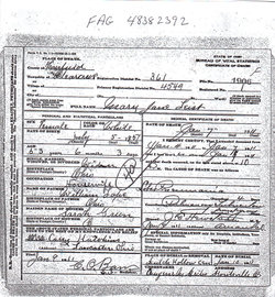
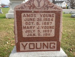
Mary Jane Lape Young Leist
| Birth | : | 5 Jul 1857 Ohio, USA |
| Death | : | 7 Jan 1911 Ohio, USA |
| Burial | : | Tuttle Cemetery, Tuttle, Kidder County, USA |
| Coordinate | : | 47.1397018, -100.0077972 |
| Inscription | : | MARY J. YOUNG JULY 5, 1857 JAN. 8, 1911 |
| Description | : | Mary Jane was the daughter of William and Sarah Green Lape, the wife of Amos Young and the mother of Harley Pearl, Kirby Clark, Ida Belle and Carrie Alice. After the death of Amos in 1887, she married Josiah Leist in 1896. He died in 1897. |
frequently asked questions (FAQ):
-
Where is Mary Jane Lape Young Leist's memorial?
Mary Jane Lape Young Leist's memorial is located at: Tuttle Cemetery, Tuttle, Kidder County, USA.
-
When did Mary Jane Lape Young Leist death?
Mary Jane Lape Young Leist death on 7 Jan 1911 in Ohio, USA
-
Where are the coordinates of the Mary Jane Lape Young Leist's memorial?
Latitude: 47.1397018
Longitude: -100.0077972
Family Members:
Spouse
Children
Flowers:


Nearby Cemetories:
1. Tuttle Cemetery
Tuttle, Kidder County, USA
Coordinate: 47.1397018, -100.0077972
2. Holy Cross Cemetery
Tuttle, Kidder County, USA
Coordinate: 47.1408005, -99.9464035
3. Zion Langedahl Cemetery
Kidder County, USA
Coordinate: 47.0825005, -100.0714035
4. Evangelical Immanuel Cemetery
Tuttle, Kidder County, USA
Coordinate: 47.0963000, -100.0950000
5. Chestina Cemetery
Kidder County, USA
Coordinate: 47.0539330, -100.0408600
6. Skudesness Lutheran Cemetery
Kidder County, USA
Coordinate: 47.0466995, -100.0072021
7. Saint Johns Cemetery
Arena, Burleigh County, USA
Coordinate: 47.1343994, -100.1564026
8. Saint Petri Cemetery
Kidder County, USA
Coordinate: 47.2291985, -99.9064026
9. Kleve Cemetery
Robinson, Kidder County, USA
Coordinate: 47.1112800, -99.8404200
10. Mennonite Zion Cemetery
Arena, Burleigh County, USA
Coordinate: 47.0794400, -100.1572400
11. Phoenix Township Cemetery
Arena, Burleigh County, USA
Coordinate: 47.1854000, -100.1996000
12. Zion Lutheran Church Cemetery
Driscoll, Burleigh County, USA
Coordinate: 46.9961900, -100.1700600
13. Bethany Cemetery
Robinson, Kidder County, USA
Coordinate: 47.1392300, -99.7351000
14. Wing Cemetery
Wing, Burleigh County, USA
Coordinate: 47.1380000, -100.2830000
15. Richmond Cemetery
Wing, Burleigh County, USA
Coordinate: 47.1922020, -100.2832570
16. Hazel Grove Cemetery
Wing, Burleigh County, USA
Coordinate: 47.3150940, -100.1690700
17. Stark Mennonite Church Cemetery
Wing, Burleigh County, USA
Coordinate: 47.3153800, -100.1770700
18. Seventh Day Adventist Cemetery
Robinson, Kidder County, USA
Coordinate: 47.2129500, -99.7148400
19. Ahola Cemetery
Wing, Burleigh County, USA
Coordinate: 47.0250626, -100.2952423
20. Allen Cemetery
Kidder County, USA
Coordinate: 46.9155998, -99.8647003
21. Fairview Cemetery
Lake Williams, Kidder County, USA
Coordinate: 47.0816803, -99.6518784
22. Chaska Gravesite
Driscoll, Burleigh County, USA
Coordinate: 46.9015700, -100.1330700
23. Methodist Episcopal Cemetery
Robinson, Kidder County, USA
Coordinate: 47.2972590, -99.7149830
24. Woodlawn Cemetery
Steele, Kidder County, USA
Coordinate: 46.8806000, -99.9094009