

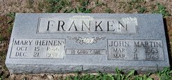
Mary Louise Heinen Franken
| Birth | : | 15 Oct 1866 Prairie Home, Cooper County, Missouri, USA |
| Death | : | 21 Dec 1937 Prairie Home, Cooper County, Missouri, USA |
| Burial | : | Newton Road Cemetery, Rushden, East Northamptonshire Borough, England |
| Coordinate | : | 52.2882140, -0.5859750 |
| Inscription | : | Daughter of Jake and Elizabeth Shreck Heinen. |
frequently asked questions (FAQ):
-
Where is Mary Louise Heinen Franken's memorial?
Mary Louise Heinen Franken's memorial is located at: Newton Road Cemetery, Rushden, East Northamptonshire Borough, England.
-
When did Mary Louise Heinen Franken death?
Mary Louise Heinen Franken death on 21 Dec 1937 in Prairie Home, Cooper County, Missouri, USA
-
Where are the coordinates of the Mary Louise Heinen Franken's memorial?
Latitude: 52.2882140
Longitude: -0.5859750
Family Members:
Parent
Spouse
Siblings

Children
Flowers:

Left by Anonymous on 18 Jan 2013

Mary Louisa Hainen aunt of wife of grand uncle Birth 15 Oct 1866 in Moniteau, Missouri, USA Death 21 Dec 1937 in Cooper County, Missouri, USA. She was the daughter of Jacob Hainen and Mary E Schreck. She was married John Franken
Left by Anonymous on 24 Mar 2013

Hail Mary full of grace, the Lord is with you! Blessed are you among all woman and blessed is the fruit of your womb, Jesus. Holy Mary Mother of God, pray for us sinners now and at the hour of our death. Amen Rest in peace.
Left by Anonymous on 22 Jul 2018


Nearby Cemetories:
1. Newton Road Cemetery
Rushden, East Northamptonshire Borough, England
Coordinate: 52.2882140, -0.5859750
2. St Mary Churchyard
Rushden, East Northamptonshire Borough, England
Coordinate: 52.2885570, -0.5973860
3. St. Mary the Virgin Churchyard
Higham Ferrers, East Northamptonshire Borough, England
Coordinate: 52.3065500, -0.5915240
4. Higham Ferrers Cemetery
Higham Ferrers, East Northamptonshire Borough, England
Coordinate: 52.3084850, -0.5945270
5. St Lawrence Churchyard
Wymington, Bedford Borough, England
Coordinate: 52.2694310, -0.6017230
6. St. Peter Churchyard
Newton Bromswold, East Northamptonshire Borough, England
Coordinate: 52.2815200, -0.5376600
7. St. John the Baptist Churchyard
Chelveston, East Northamptonshire Borough, England
Coordinate: 52.3112800, -0.5501200
8. Irchester Saint Katherine Churchyard
Irchester, Wellingborough Borough, England
Coordinate: 52.2843900, -0.6446900
9. Irchester Cemetery
Irchester, Wellingborough Borough, England
Coordinate: 52.2848000, -0.6456000
10. New Irthlingborough Cemetery
Irthlingborough, East Northamptonshire Borough, England
Coordinate: 52.3178531, -0.6294229
11. St Peter's Churchyard
Irthlingborough, East Northamptonshire Borough, England
Coordinate: 52.3251642, -0.6101925
12. St Mary the Virgin Churchyard
Podington, Bedford Borough, England
Coordinate: 52.2539100, -0.6220900
13. St. Mary the Virgin Churchyard
Yelden, Bedford Borough, England
Coordinate: 52.2930600, -0.5182700
14. St. Michael's Church
Farndish, Bedford Borough, England
Coordinate: 52.2638108, -0.6416839
15. St. Margaret of Antioch Churchyard
Knotting, Bedford Borough, England
Coordinate: 52.2599172, -0.5323686
16. Stanwick Cemetery
Stanwick, East Northamptonshire Borough, England
Coordinate: 52.3298800, -0.5531500
17. St. Laurence Churchyard Stanwick
Stanwick, East Northamptonshire Borough, England
Coordinate: 52.3324970, -0.5628585
18. All Saints Churchyard
Souldrop, Bedford Borough, England
Coordinate: 52.2433000, -0.5584000
19. St. Mary Magdalene Churchyard
Melchbourne, Bedford Borough, England
Coordinate: 52.2770600, -0.4935690
20. Wollaston
Wollaston, Wellingborough Borough, England
Coordinate: 52.2581088, -0.6726313
21. London Road Cemetery
Wellingborough, Wellingborough Borough, England
Coordinate: 52.2986000, -0.6878000
22. All Saints Churchyard
Wellingborough, Wellingborough Borough, England
Coordinate: 52.3010890, -0.6879730
23. St Mary the Virgin Churchyard
Shelton, Bedford Borough, England
Coordinate: 52.3076000, -0.4852000
24. Raunds Cemetery
Raunds, East Northamptonshire Borough, England
Coordinate: 52.3494100, -0.5467400