
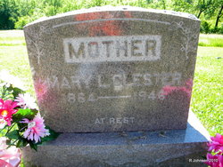
Mary Lucinda Van Dorin Clester
| Birth | : | 28 Mar 1864 Salem, Henry County, Iowa, USA |
| Death | : | 11 Nov 1946 Moravia, Appanoose County, Iowa, USA |
| Burial | : | Nativity of the Blessed Virgin Mary Churchyard, Ringstead, East Northamptonshire Borough, England |
| Coordinate | : | 52.3652660, -0.5533620 |
| Plot | : | Row 2 |
| Description | : | MARY CLESTER IS CALLED BY DEATH Mary Lucinda, daughter of James and Mary VanDorin was born near Salem, Iowa, on March 28, 1864 and passed away at her home in Moravia, Nov. 11, 1946, at the age of 82 years, seven months and 14 days. She was united in marriage to James A. Clester and they made their home near Sinica, Kansas for several years, later moving to Iowa. She came to Moravia about forty-five years ago and established a home for herself and children. To this union six children were born, two daughters and four... Read More |
frequently asked questions (FAQ):
-
Where is Mary Lucinda Van Dorin Clester's memorial?
Mary Lucinda Van Dorin Clester's memorial is located at: Nativity of the Blessed Virgin Mary Churchyard, Ringstead, East Northamptonshire Borough, England.
-
When did Mary Lucinda Van Dorin Clester death?
Mary Lucinda Van Dorin Clester death on 11 Nov 1946 in Moravia, Appanoose County, Iowa, USA
-
Where are the coordinates of the Mary Lucinda Van Dorin Clester's memorial?
Latitude: 52.3652660
Longitude: -0.5533620
Family Members:
Parent

Siblings
Children
Flowers:


Nearby Cemetories:
1. Nativity of the Blessed Virgin Mary Churchyard
Ringstead, East Northamptonshire Borough, England
Coordinate: 52.3652660, -0.5533620
2. Station Street Cemetery
Ringstead, East Northamptonshire Borough, England
Coordinate: 52.3654427, -0.5538628
3. Station Road Cemetery
Ringsted Kommune, Denmark
Coordinate: 52.3638126, -0.5592430
4. Holy Trinity Church
Denford, East Northamptonshire Borough, England
Coordinate: 52.3787353, -0.5450568
5. Raunds Cemetery
Raunds, East Northamptonshire Borough, England
Coordinate: 52.3494100, -0.5467400
6. All Saints Churchyard
Great Addington, East Northamptonshire Borough, England
Coordinate: 52.3657660, -0.5937010
7. St. Laurence Churchyard Stanwick
Stanwick, East Northamptonshire Borough, England
Coordinate: 52.3324970, -0.5628585
8. St. Nicholas Churchyard
Islip, East Northamptonshire Borough, England
Coordinate: 52.3991300, -0.5513600
9. Stanwick Cemetery
Stanwick, East Northamptonshire Borough, England
Coordinate: 52.3298800, -0.5531500
10. Thrapston Cemetery
Thrapston, East Northamptonshire Borough, England
Coordinate: 52.4000170, -0.5292640
11. St. Nicholas' Churchyard
Twywell, East Northamptonshire Borough, England
Coordinate: 52.3936001, -0.6024166
12. St. Peter's Churchyard
Lowick, East Northamptonshire Borough, England
Coordinate: 52.4116300, -0.5570600
13. St Peter's Churchyard
Irthlingborough, East Northamptonshire Borough, England
Coordinate: 52.3251642, -0.6101925
14. St. Mary's Churchyard
Titchmarsh, East Northamptonshire Borough, England
Coordinate: 52.4076080, -0.4998860
15. St. John the Baptist Churchyard
Chelveston, East Northamptonshire Borough, England
Coordinate: 52.3112800, -0.5501200
16. St. John's Churchyard
Cranford St John, Kettering Borough, England
Coordinate: 52.3840560, -0.6391670
17. St. Andrew's Churchyard
Cranford, Kettering Borough, England
Coordinate: 52.3856700, -0.6438700
18. All Hallow's Church Hargrave Churchyard
Hargrave, East Northamptonshire Borough, England
Coordinate: 52.3242316, -0.4800580
19. All Saints Churchyard
Aldwincle, East Northamptonshire Borough, England
Coordinate: 52.4222080, -0.5142150
20. Higham Ferrers Cemetery
Higham Ferrers, East Northamptonshire Borough, England
Coordinate: 52.3084850, -0.5945270
21. St. Mary the Virgin Churchyard
Higham Ferrers, East Northamptonshire Borough, England
Coordinate: 52.3065500, -0.5915240
22. Aldwincle St Peters Churchyard
Aldwincle, East Northamptonshire Borough, England
Coordinate: 52.4255060, -0.5217460
23. All Saints Church
Sudborough, East Northamptonshire Borough, England
Coordinate: 52.4283980, -0.5782500
24. New Irthlingborough Cemetery
Irthlingborough, East Northamptonshire Borough, England
Coordinate: 52.3178531, -0.6294229