


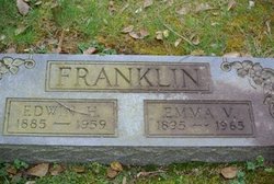
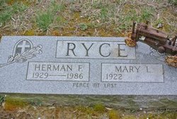
Mary Lydia Franklin Ryce
| Birth | : | 24 May 1922 Pisgah, Charles County, Maryland, USA |
| Death | : | 12 Apr 2004 La Plata, Charles County, Maryland, USA |
| Burial | : | Freeman Cemetery, Sandwich, Barnstable County, USA |
| Coordinate | : | 41.7573013, -70.5083008 |
| Description | : | Mary Lydia Ryce May 24, 1922 - April 12, 2014 Mary Lydia Ryce of Indian Head, Maryland, died on Saturday, April 12, 2014 at the Charles County Nursing and Rehabilitation Center in La Plata. She was 91 years old. Born on May 24, 1922 in Pisgah Maryland, she was the daughter of the late Emma V. Davis Franklin and the late Edwin H. Franklin. Mrs. Ryce was a homemaker and mom. She enjoyed cooking and preparing meals for anyone and everyone, doing ceramics, grocery shopping and vegetable gardening. In addition to her... Read More |
frequently asked questions (FAQ):
-
Where is Mary Lydia Franklin Ryce's memorial?
Mary Lydia Franklin Ryce's memorial is located at: Freeman Cemetery, Sandwich, Barnstable County, USA.
-
When did Mary Lydia Franklin Ryce death?
Mary Lydia Franklin Ryce death on 12 Apr 2004 in La Plata, Charles County, Maryland, USA
-
Where are the coordinates of the Mary Lydia Franklin Ryce's memorial?
Latitude: 41.7573013
Longitude: -70.5083008
Family Members:
Parent

Spouse
Children
Flowers:


Nearby Cemetories:
1. Freeman Cemetery
Sandwich, Barnstable County, USA
Coordinate: 41.7573013, -70.5083008
2. Bay View Cemetery
Sandwich, Barnstable County, USA
Coordinate: 41.7583008, -70.5102997
3. Old Town Cemetery
Sandwich, Barnstable County, USA
Coordinate: 41.7556992, -70.5011978
4. Saint Peters Cemetery
Sandwich, Barnstable County, USA
Coordinate: 41.7502480, -70.5079346
5. Saddle and Pillion Cemetery
Sagamore, Barnstable County, USA
Coordinate: 41.7672005, -70.5192032
6. Mount Hope Cemetery
Sandwich, Barnstable County, USA
Coordinate: 41.7518997, -70.4850006
7. Almshouse Burial Ground
Sandwich, Barnstable County, USA
Coordinate: 41.7501000, -70.4847000
8. Sagamore Cemetery
Bourne, Barnstable County, USA
Coordinate: 41.7714005, -70.5339966
9. Spring Hill Cemetery
Sandwich, Barnstable County, USA
Coordinate: 41.7487984, -70.4775009
10. Old Quaker Meeting House Cemetery at Spring Hill
Sandwich, Barnstable County, USA
Coordinate: 41.7463100, -70.4613060
11. Quaker Meeting House Cemetery
East Sandwich, Barnstable County, USA
Coordinate: 41.7469673, -70.4591064
12. Bournedale Burying Hill
Bourne, Barnstable County, USA
Coordinate: 41.7741520, -70.5611730
13. Sandwich Town Cemetery
Sandwich, Barnstable County, USA
Coordinate: 41.7125300, -70.4909000
14. Bournedale Herring Pond Indian Cemetery
Bourne, Barnstable County, USA
Coordinate: 41.7861900, -70.5658722
15. Cedarville Cemetery
East Sandwich, Barnstable County, USA
Coordinate: 41.7397804, -70.4428864
16. Herring Pond Wampanoag Indian Cemetery
Plymouth, Plymouth County, USA
Coordinate: 41.7867290, -70.5658940
17. Herring Pond Cemetery
Plymouth, Plymouth County, USA
Coordinate: 41.7971700, -70.5588800
18. Cedarville Cemetery
Plymouth, Plymouth County, USA
Coordinate: 41.8049736, -70.5560837
19. Tobey Cemetery
Forestdale, Barnstable County, USA
Coordinate: 41.6972008, -70.4875031
20. Bourne Village Cemetery
Bourne, Barnstable County, USA
Coordinate: 41.7425117, -70.5938110
21. Nightingale Cemetery
Plymouth, Plymouth County, USA
Coordinate: 41.8113400, -70.5588260
22. Forestdale Cemetery
Forestdale, Barnstable County, USA
Coordinate: 41.6903000, -70.5024033
23. Lakewood Cemetery
Plymouth, Plymouth County, USA
Coordinate: 41.8141260, -70.5567690
24. Bourne Family Cemetery #02
Bourne, Barnstable County, USA
Coordinate: 41.7577230, -70.6001190