
Mary McConochie Wilson
| Birth | : | 4 Feb 1836 |
| Death | : | 2 Jun 1921 |
| Burial | : | Saint Peter's Cemetery, Ellastone, East Staffordshire Borough, England |
| Coordinate | : | 52.9882900, -1.8275000 |
| Plot | : | 135 |
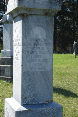
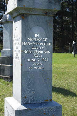
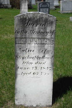
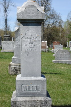
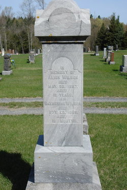
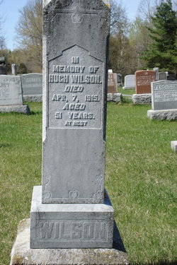
| Description | : | Mary was born Feb.4,1836 in North Sherbrooke Township, Lanark County, Ontario, the daughter of Hugh McConachie and Katherine Ferguson. She was married to Robert Burns Wilson in 1859. They had six children; Alexander, Catherine, Hugh, Margaret, Robert and George. Mary was living at Lot 12, Con 2, of North Sherbrooke, when she died on June 2,1921. ------------------------------- Plot 135 : (side 1 of stone) - In memory of, - Robert B. Wilson, died Oct.11,1899, aged 64 years. (side 2 of stone) - In memory of, - Mary McConochie, wife of Robt. B. Wilson, died June 2,1921, aged 85 yrs. (side 3 of stone) - In memory of, - Alick Wilson,... Read More |
frequently asked questions (FAQ):
-
Where is Mary McConochie Wilson's memorial?
Mary McConochie Wilson's memorial is located at: Saint Peter's Cemetery, Ellastone, East Staffordshire Borough, England.
-
When did Mary McConochie Wilson death?
Mary McConochie Wilson death on 2 Jun 1921 in
-
Where are the coordinates of the Mary McConochie Wilson's memorial?
Latitude: 52.9882900
Longitude: -1.8275000
Family Members:
Parent
Spouse
Siblings
Children


Flowers:


Nearby Cemetories:
1. Saint Peter's Cemetery
Ellastone, East Staffordshire Borough, England
Coordinate: 52.9882900, -1.8275000
2. St. Mary and St. Barlock Churchyard
Norbury, Derbyshire Dales District, England
Coordinate: 52.9787350, -1.8146430
3. St. Mary's Churchyard
Stanton, East Staffordshire Borough, England
Coordinate: 53.0109590, -1.8136560
4. St. Peter's Churchyard
Snelston, Derbyshire Dales District, England
Coordinate: 52.9871570, -1.7700260
5. St. John the Baptist Churchyard
Mayfield, East Staffordshire Borough, England
Coordinate: 52.9998700, -1.7716970
6. St. Peter's Churchyard
Alton, Staffordshire Moorlands District, England
Coordinate: 52.9783470, -1.8918600
7. St John Churchyard
Alton, Staffordshire Moorlands District, England
Coordinate: 52.9783380, -1.8919190
8. Holy Trinity Churchyard
Clifton, Derbyshire Dales District, England
Coordinate: 53.0002710, -1.7545890
9. St. John the Baptist Churchyard
Cotton, Staffordshire Moorlands District, England
Coordinate: 53.0150546, -1.9026792
10. St. Giles Churchyard
Marston Montgomery, Derbyshire Dales District, England
Coordinate: 52.9382120, -1.8007610
11. Ashbourne Cemetery
Ashbourne, Derbyshire Dales District, England
Coordinate: 53.0109900, -1.7482450
12. St Leonard Churchyard
Bradley in the Moors, Staffordshire Moorlands District, England
Coordinate: 52.9693440, -1.9135150
13. St. Bartholomew's Churchyard
Blore, Derbyshire Dales District, England
Coordinate: 53.0408190, -1.7967020
14. Saint Bartholomew Churchyard
Blore, Staffordshire Moorlands District, England
Coordinate: 53.0411100, -1.7963100
15. All Saints Church
Okeover, East Staffordshire Borough, England
Coordinate: 53.0302050, -1.7650989
16. Croxden Abbey
Croxden, East Staffordshire Borough, England
Coordinate: 52.9549890, -1.9042630
17. St. James' Churchyard
Edlaston, Derbyshire Dales District, England
Coordinate: 52.9811080, -1.7316130
18. Cotton Cemetery
Cotton, Staffordshire Moorlands District, England
Coordinate: 53.0188110, -1.9113960
19. Holy Trinity Churchyard
Oakamoor, Staffordshire Moorlands District, England
Coordinate: 53.0003870, -1.9236580
20. St Oswald Churchyard
Ashbourne, Derbyshire Dales District, England
Coordinate: 53.0149220, -1.7386720
21. Mapleton, St Mary
Ashbourne, Derbyshire Dales District, England
Coordinate: 53.0294190, -1.7544910
22. St. Mary's Churchyard
Mappleton, Derbyshire Dales District, England
Coordinate: 53.0294920, -1.7542220
23. St Mary's Churchyard
Calton, Staffordshire Moorlands District, England
Coordinate: 53.0489970, -1.8472480
24. St Mary and St Laurence Churchyard
Cauldon, Staffordshire Moorlands District, England
Coordinate: 53.0423040, -1.8845550