
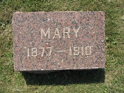

Mary Schoulte
| Birth | : | 16 Oct 1877 Farmersburg, Clayton County, Iowa, USA |
| Death | : | 23 Oct 1910 Lyman County, South Dakota, USA |
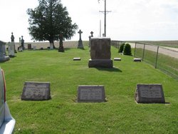
| Burial | : | St. Michael's Churchyard, Buslingthorpe, West Lindsey District, England |
| Coordinate | : | 53.3520370, -0.3772470 |
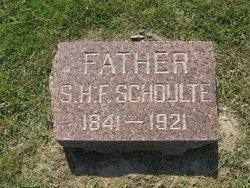
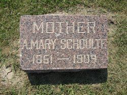
| Description | : | Register And Argus, IA, Thursday, November 3, 1910, pg. 7, col. 2 OBITUARY. Mary Schoulte, daughter of S. H. F. Schoulte, of National, was born Oct. 16, 1877 at died at Hilmoe, S. D., on Sunday morning, Oct. 23. In 1906 she, with three sisters, went to S. D. and made entries on homesteads near Presho. After proving up on their claims the other sisters returned home, while she remained to keep house for her brother William. About a year ago she was called home to attend the funeral of her mother and at this time contracted a cold from which she only... Read More |
frequently asked questions (FAQ):
-
Where is Mary Schoulte's memorial?
Mary Schoulte's memorial is located at: St. Michael's Churchyard, Buslingthorpe, West Lindsey District, England.
-
When did Mary Schoulte death?
Mary Schoulte death on 23 Oct 1910 in Lyman County, South Dakota, USA
-
Where are the coordinates of the Mary Schoulte's memorial?
Latitude: 53.3520370
Longitude: -0.3772470
Family Members:
Parent
Siblings
Flowers:


Nearby Cemetories:
1. St. Michael's Churchyard
Buslingthorpe, West Lindsey District, England
Coordinate: 53.3520370, -0.3772470
2. All Saints Churchyard
Faldingworth, West Lindsey District, England
Coordinate: 53.3490800, -0.3995900
3. St. Peter's Churchyard
Friesthorpe, West Lindsey District, England
Coordinate: 53.3367420, -0.3915860
4. St. Cornelius Churchyard
Linwood, West Lindsey District, England
Coordinate: 53.3626176, -0.3361707
5. St. John The Baptist Churchyard
Lissington, West Lindsey District, England
Coordinate: 53.3363600, -0.3359800
6. St Michaels Churchyard
Newton by Toft, West Lindsey District, England
Coordinate: 53.3726210, -0.4216430
7. St. Lawrence Churchyard
Snarford, West Lindsey District, England
Coordinate: 53.3283300, -0.4239900
8. God's Acre
Middle Rasen, West Lindsey District, England
Coordinate: 53.3904700, -0.3614800
9. St. Peter & St. Paul Churchyard
Middle Rasen, West Lindsey District, England
Coordinate: 53.3914120, -0.3664170
10. All Saints Churchyard
Snelland, West Lindsey District, England
Coordinate: 53.3120800, -0.3812000
11. Market Rasen Cemetery
Market Rasen, West Lindsey District, England
Coordinate: 53.3830880, -0.3275890
12. St. Thomas Churchyard
Market Rasen, West Lindsey District, England
Coordinate: 53.3883500, -0.3376700
13. All Saints Churchyard
Cold Hanworth, West Lindsey District, England
Coordinate: 53.3357700, -0.4471700
14. All Saints Churchyard
Holton-cum-Beckering, West Lindsey District, England
Coordinate: 53.3167370, -0.3257753
15. St. Oswald's Churchyard
Rand, West Lindsey District, England
Coordinate: 53.2970600, -0.3404500
16. St. Helen's Churchyard
Saxby, West Lindsey District, England
Coordinate: 53.3625100, -0.4920400
17. Kirkby cum Osgodby Cemetery
Kirkby cum Osgodby, West Lindsey District, England
Coordinate: 53.4202700, -0.3977200
18. St. John the Baptist Churchyard
Langworth, West Lindsey District, England
Coordinate: 53.2843900, -0.4086800
19. St Andrew Churchyard
Kirkby cum Osgodby, West Lindsey District, England
Coordinate: 53.4210980, -0.4015720
20. St Chad Church Extension
Dunholme, West Lindsey District, England
Coordinate: 53.3008900, -0.4621500
21. St. Chad Churchyard
Dunholme, West Lindsey District, England
Coordinate: 53.3018330, -0.4638100
22. St Peter Churchyard
Kingerby, West Lindsey District, England
Coordinate: 53.4218900, -0.4104000
23. St. Peter & Paul Churchyard
Owmby-by-Spital, West Lindsey District, England
Coordinate: 53.3735080, -0.4981220
24. St. Peter's Churchyard
Normanby by Spital, West Lindsey District, England
Coordinate: 53.3802120, -0.4963050