
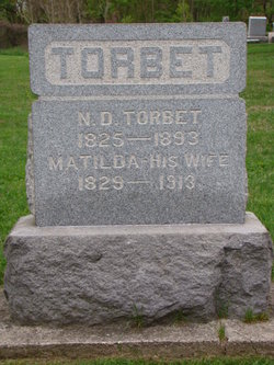
Matilda Egolf Torbet
| Birth | : | 1829 |
| Death | : | 1913 |
| Burial | : | Sunset View Cemetery, El Cerrito, Contra Costa County, USA |
| Coordinate | : | 37.9077721, -122.2871017 |
| Plot | : | Masonic |
| Inscription | : | w/o ND |
| Description | : | name : Matilda Torbit event: Census event date: 1880 event place: Columbia City, Whitley, Indiana, United States gender: Female age: 50 marital status : Married occupation : Keep House race or color (original) : ethnicity (standardized) : American relationship to head : Wife birthplace : Ohio, United States birthdate : 1830 spouse's name : Nelson Torbit spouse's birthplace : Pennsylvania, United States father's name : father's birthplace : Pennsylvania, United States mother's name : mother's birthplace : Virginia, United States page : 455 ... Read More |
frequently asked questions (FAQ):
-
Where is Matilda Egolf Torbet's memorial?
Matilda Egolf Torbet's memorial is located at: Sunset View Cemetery, El Cerrito, Contra Costa County, USA.
-
When did Matilda Egolf Torbet death?
Matilda Egolf Torbet death on 1913 in
-
Where are the coordinates of the Matilda Egolf Torbet's memorial?
Latitude: 37.9077721
Longitude: -122.2871017
Family Members:
Parent
Spouse

Siblings
Children
Flowers:


Nearby Cemetories:
1. Sunset View Cemetery
El Cerrito, Contra Costa County, USA
Coordinate: 37.9077721, -122.2871017
2. Golden Gate Mausoleum and Columbaria
El Cerrito, Contra Costa County, USA
Coordinate: 37.9073150, -122.2857220
3. Northbrae Community Church Columbarium
Berkeley, Alameda County, USA
Coordinate: 37.8905500, -122.2763200
4. Golden Gate Fields
Albany, Alameda County, USA
Coordinate: 37.8854000, -122.3117000
5. Salesian Cemetery
Richmond, Contra Costa County, USA
Coordinate: 37.9532650, -122.3401230
6. Saint Joseph Catholic Cemetery
San Pablo, Contra Costa County, USA
Coordinate: 37.9612700, -122.3336600
7. Saint Pauls Cemetery (Defunct)
San Pablo, Contra Costa County, USA
Coordinate: 37.9563332, -122.3430099
8. Rolling Hills Memorial Park
Richmond, Contra Costa County, USA
Coordinate: 37.9756012, -122.3146973
9. Saint Mary's Cemetery
Oakland, Alameda County, USA
Coordinate: 37.8349991, -122.2418976
10. Home of Eternity Cemetery
Oakland, Alameda County, USA
Coordinate: 37.8322970, -122.2448270
11. Chapel of the Chimes Columbarium and Mausoleum
Oakland, Alameda County, USA
Coordinate: 37.8318863, -122.2456894
12. Chapel of Memories Columbarium
Oakland, Alameda County, USA
Coordinate: 37.8310471, -122.2480927
13. Gan Shalom Cemetery
Contra Costa County, USA
Coordinate: 37.9528122, -122.1975098
14. Mountain View Cemetery
Oakland, Alameda County, USA
Coordinate: 37.8327600, -122.2395200
15. Saint Stephens Episcopal Church Memorial Garden
Orinda, Contra Costa County, USA
Coordinate: 37.8982650, -122.1729170
16. Cathedral of Christ the Light Mausoleum
Oakland, Alameda County, USA
Coordinate: 37.8105316, -122.2633896
17. Lafayette-Orinda Presbyterian Church Garden
Contra Costa County, USA
Coordinate: 37.8866040, -122.1606950
18. Yerba Buena Island Cemetery (Defunct)
San Francisco, San Francisco County, USA
Coordinate: 37.8127420, -122.3707880
19. Saint Paul Lutheran Church
Oakland, Alameda County, USA
Coordinate: 37.8020820, -122.2222780
20. Angel Island Cemetery (defunct)
Tiburon, Marin County, USA
Coordinate: 37.8621830, -122.4325920
21. Home of Peace Cemetery
Oakland, Alameda County, USA
Coordinate: 37.7790604, -122.2036285
22. First Street Cemetery (Defunct)
San Francisco, San Francisco County, USA
Coordinate: 37.7906170, -122.3991770
23. Muir-Strentzel Hanna Cemetery
Martinez, Contra Costa County, USA
Coordinate: 37.9784393, -122.1232681
24. Bush Street Cemetery (Defunct)
San Francisco, San Francisco County, USA
Coordinate: 37.7907950, -122.4011960