Maxwell Archie “Max” Marchesseau
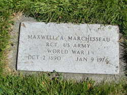
| Birth | : | 2 Oct 1890 Mountain View, Uinta County, Wyoming, USA |
| Death | : | 9 Jan 1976 Brewster, Okanogan County, Washington, USA |
| Burial | : | Mineola Cemetery, Mineola, Mills County, USA |
| Coordinate | : | 41.1391130, -95.6941800 |
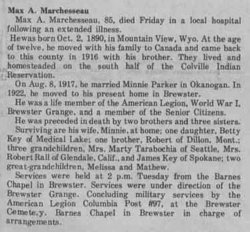
| Description | : | Max A Marchesseau, 85, died Friday in a local hospital following an extended illness. He was born Oct. 2, 1890, in Mountain View, Wyo. At the age of twelve, he moved with his family to Canada and came back to this county in 1916 with his brother. They lived and homesteaded on the south half of the Colville Indian Reservation. On Aug. 8, 1917, he married Minnie Parker in Okanogan. In 1922, he moved to his present home in Brewster. He was a life member of the American Legion, World War I, Brewster Grange, and a member of the Senior Citizens. Surviving are his... Read More |
frequently asked questions (FAQ):
-
Where is Maxwell Archie “Max” Marchesseau's memorial?
Maxwell Archie “Max” Marchesseau's memorial is located at: Mineola Cemetery, Mineola, Mills County, USA.
-
When did Maxwell Archie “Max” Marchesseau death?
Maxwell Archie “Max” Marchesseau death on 9 Jan 1976 in Brewster, Okanogan County, Washington, USA
-
Where are the coordinates of the Maxwell Archie “Max” Marchesseau's memorial?
Latitude: 41.1391130
Longitude: -95.6941800
Family Members:
Parent
Spouse
Siblings
Children
Flowers:
Nearby Cemetories:
1. Mineola Cemetery
Mineola, Mills County, USA
Coordinate: 41.1391130, -95.6941800
2. Saint Boniface Catholic Cemetery
Mills County, USA
Coordinate: 41.1419000, -95.7467100
3. Zion Cemetery
Pottawattamie County, USA
Coordinate: 41.1778000, -95.7272000
4. Keg Creek Township Cemetery
Treynor, Pottawattamie County, USA
Coordinate: 41.1913986, -95.6893997
5. Salem Lutheran Church Cemetery
Glenwood, Mills County, USA
Coordinate: 41.1556015, -95.7617035
6. Saint Pauls Evangelical Country Church Cemetery
Dumfries, Pottawattamie County, USA
Coordinate: 41.1748352, -95.7492371
7. Silver City Cemetery
Silver City, Mills County, USA
Coordinate: 41.1042442, -95.6380005
8. Saar's Field Cemetery
Mills County, USA
Coordinate: 41.1255500, -95.7725000
9. West Liberty Cemetery
Glenwood, Mills County, USA
Coordinate: 41.0956001, -95.7536011
10. Glenwood Catholic Cemetery
Glenwood, Mills County, USA
Coordinate: 41.0600000, -95.7453000
11. Glenwood Cemetery
Glenwood, Mills County, USA
Coordinate: 41.0599670, -95.7480240
12. Wall Cemetery
Mineola, Mills County, USA
Coordinate: 41.1157990, -95.8153000
13. Mills County Farm Cemetery
Glenwood, Mills County, USA
Coordinate: 41.0417930, -95.6756530
14. Gowens-Turner Cemetery
Glenwood, Mills County, USA
Coordinate: 41.0715510, -95.7952420
15. Bomar Family Cemetery
Mills County, USA
Coordinate: 41.0369400, -95.6941700
16. Saint Paul Lutheran Cemetery
Treynor, Pottawattamie County, USA
Coordinate: 41.2322000, -95.6380000
17. Lewis Township Cemetery
Council Bluffs, Pottawattamie County, USA
Coordinate: 41.2117004, -95.7938995
18. East Liberty Cemetery
Malvern, Mills County, USA
Coordinate: 41.0592346, -95.6005020
19. Glenwood Resource Center Cemetery
Glenwood, Mills County, USA
Coordinate: 41.0361720, -95.7338590
20. Godsey Cemetery
Mills County, USA
Coordinate: 41.0705986, -95.8075027
21. Martin Chapel Cemetery
Pacific City, Mills County, USA
Coordinate: 41.0611000, -95.8013992
22. Zion Congregational Cemetery
Treynor, Pottawattamie County, USA
Coordinate: 41.2325090, -95.6079200
23. Saint Marys Cemetery
Mills County, USA
Coordinate: 41.1517580, -95.8514000
24. Maple Grove Cemetery
Council Bluffs, Pottawattamie County, USA
Coordinate: 41.2265560, -95.8187100

