

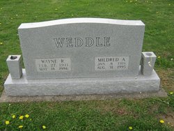
Mildred Ann Gorby Weddle
| Birth | : | 8 Jan 1916 |
| Death | : | 31 Aug 1995 |
| Burial | : | St Oswald Churchyard, Arncliffe, Craven District, England |
| Coordinate | : | 54.1434970, -2.1038940 |
| Plot | : | Section A |
| Description | : | Shares memorial with Wayne R Weddle |
frequently asked questions (FAQ):
-
Where is Mildred Ann Gorby Weddle's memorial?
Mildred Ann Gorby Weddle's memorial is located at: St Oswald Churchyard, Arncliffe, Craven District, England.
-
When did Mildred Ann Gorby Weddle death?
Mildred Ann Gorby Weddle death on 31 Aug 1995 in
-
Where are the coordinates of the Mildred Ann Gorby Weddle's memorial?
Latitude: 54.1434970
Longitude: -2.1038940
Family Members:
Parent

Spouse
Siblings
Flowers:


Nearby Cemetories:
1. St Oswald Churchyard
Arncliffe, Craven District, England
Coordinate: 54.1434970, -2.1038940
2. St Mary Churchyard
Kettlewell, Craven District, England
Coordinate: 54.1459650, -2.0454120
3. St. Michael and All Angels Churchyard
Hubberholme, Craven District, England
Coordinate: 54.2001100, -2.1147330
4. St. Mary's Churchyard
Conistone, Craven District, England
Coordinate: 54.1042630, -2.0304750
5. Grassington Congregational Churchyard
Grassington, Craven District, England
Coordinate: 54.0723570, -1.9963100
6. St. Michael and All Angels Churchyard
Linton, Craven District, England
Coordinate: 54.0647950, -1.9933070
7. St Michael the Archangel Churchyard
Kirkby Malham, Craven District, England
Coordinate: 54.0448480, -2.1628540
8. St Peter Churchyard
Stainforth, Craven District, England
Coordinate: 54.1019280, -2.2754890
9. St Oswald Churchyard
Horton-in-Ribblesdale, Craven District, England
Coordinate: 54.1445140, -2.2922550
10. St Peter Churchyard
Hebden, Craven District, England
Coordinate: 54.0626500, -1.9618960
11. St John the Evangelist Churchyard
Langcliffe, Craven District, England
Coordinate: 54.0807400, -2.2721000
12. St Peter Churchyard
Rylstone, Craven District, England
Coordinate: 54.0253360, -2.0445780
13. Holy Ascension Churchyard
Settle, Craven District, England
Coordinate: 54.0704320, -2.2775390
14. Zion Congregational Chapelyard
Settle, Craven District, England
Coordinate: 54.0672490, -2.2747040
15. St Matthew Churchyard
Stalling Busk, Richmondshire District, England
Coordinate: 54.2686220, -2.1302030
16. St Matthew Old Churchyard
Stalling Busk, Richmondshire District, England
Coordinate: 54.2695500, -2.1289300
17. Friends Burial Ground
Settle, Craven District, England
Coordinate: 54.0685370, -2.2791100
18. St Wilfrid Churchyard
Burnsall, Craven District, England
Coordinate: 54.0495000, -1.9520690
19. St Alkelda Churchyard
Giggleswick, Craven District, England
Coordinate: 54.0721700, -2.2894600
20. St Botolph Churchyard
Horsehouse, Richmondshire District, England
Coordinate: 54.2269100, -1.9292300
21. St Chad Churchyard
Middlesmoor, Harrogate Borough, England
Coordinate: 54.1630080, -1.8597240
22. St. Peter's Churchyard
Coniston Cold, Craven District, England
Coordinate: 53.9944380, -2.1493870
23. St Mary the Virgin Churchyard
Long Preston, Craven District, England
Coordinate: 54.0183790, -2.2497690
24. Long Preston Baptist Chapel
Long Preston, Craven District, England
Coordinate: 54.0204249, -2.2560031