
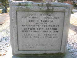
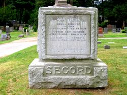
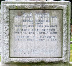
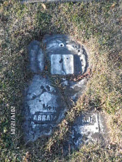
Milo Secord
| Birth | : | 4 Sep 1847 |
| Death | : | 1 Oct 1925 |
| Burial | : | Hitchin Cemetery, Hitchin, North Hertfordshire District, England |
| Coordinate | : | 51.9429090, -0.2732690 |
| Plot | : | Range 18, Lot 11, Gr4 |
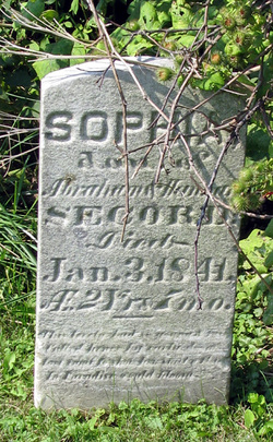
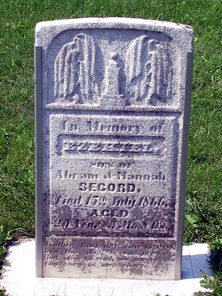
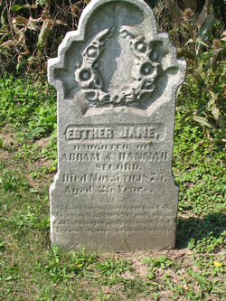
| Description | : | Son of Hannah (Abbott) and Abraham Secord. |
frequently asked questions (FAQ):
-
Where is Milo Secord's memorial?
Milo Secord's memorial is located at: Hitchin Cemetery, Hitchin, North Hertfordshire District, England.
-
When did Milo Secord death?
Milo Secord death on 1 Oct 1925 in
-
Where are the coordinates of the Milo Secord's memorial?
Latitude: 51.9429090
Longitude: -0.2732690
Family Members:
Parent

Spouse

Siblings
Flowers:


Nearby Cemetories:
1. Hitchin Cemetery
Hitchin, North Hertfordshire District, England
Coordinate: 51.9429090, -0.2732690
2. St Ippolyts Church
St Ippolyts, North Hertfordshire District, England
Coordinate: 51.9298460, -0.2591680
3. St Martins
Preston, North Hertfordshire District, England
Coordinate: 51.9091932, -0.2876494
4. Minsden Chapel
Hitchin, North Hertfordshire District, England
Coordinate: 51.9069200, -0.2595700
5. All Saints Churchyard
Willian, North Hertfordshire District, England
Coordinate: 51.9609140, -0.2191160
6. Icknield Way Cemetery
Letchworth, North Hertfordshire District, England
Coordinate: 51.9787300, -0.2506100
7. St Mary Magdalene Churchyard
Offley, North Hertfordshire District, England
Coordinate: 51.9277300, -0.3357400
8. North Hertfordshire Memorial Park and Crematorium
Holwell, North Hertfordshire District, England
Coordinate: 51.9847244, -0.2967870
9. Wilbury Hills Cemetery
Letchworth, North Hertfordshire District, England
Coordinate: 51.9862210, -0.2474770
10. Saint Mary the Virgin Churchyard
Pirton, North Hertfordshire District, England
Coordinate: 51.9722000, -0.3316600
11. St Nicholas Churchyard
Stevenage, Stevenage Borough, England
Coordinate: 51.9201590, -0.1974750
12. Weston Road Cemetery
Stevenage, Stevenage Borough, England
Coordinate: 51.9217860, -0.1935160
13. High Street Methodist Church
Stevenage, Stevenage Borough, England
Coordinate: 51.9080740, -0.2061550
14. Almond Lane Cemetery
Stevenage, Stevenage Borough, England
Coordinate: 51.9161780, -0.1954710
15. All Saints Churchyard
St Pauls Walden, North Hertfordshire District, England
Coordinate: 51.8865400, -0.2689200
16. Fairfield Hospital Cemetery
Stotfold, Central Bedfordshire Unitary Authority, England
Coordinate: 52.0040420, -0.2495440
17. St Nicholas Churchyard
Letchworth, North Hertfordshire District, England
Coordinate: 51.9948300, -0.2078900
18. Baldock Cemetery
Baldock, North Hertfordshire District, England
Coordinate: 51.9901010, -0.1960690
19. Breachwood Green Baptist Church
Kings Walden, North Hertfordshire District, England
Coordinate: 51.8843200, -0.3293700
20. St Mary Churchyard
Baldock, North Hertfordshire District, England
Coordinate: 51.9897380, -0.1898930
21. All Saints Churchyard
Upper Stondon, Central Bedfordshire Unitary Authority, England
Coordinate: 52.0065450, -0.3258350
22. All Saints Churchyard
Radwell, North Hertfordshire District, England
Coordinate: 51.9747300, -0.1668550
23. All Saints Churchyard
Shillington, Central Bedfordshire Unitary Authority, England
Coordinate: 51.9921700, -0.3648200
24. St. Faith's Churchyard
Hexton, North Hertfordshire District, England
Coordinate: 51.9609275, -0.3944721