
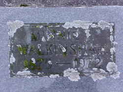


Minnie Frances Harris Walkinshaw
| Birth | : | 31 Aug 1875 Nuckolls County, Nebraska, USA |
| Death | : | 14 Jun 1972 Mount Vernon, Skagit County, Washington, USA |
| Burial | : | North Sandwich Cemetery, North Sandwich, Carroll County, USA |
| Coordinate | : | 43.8410750, -71.3953610 |
| Plot | : | Old Section |
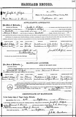
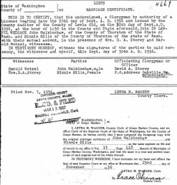
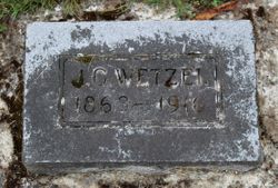
| Description | : | Father: Alfred Harris Mother: Elizabeth [JACOBS] Harris Step-mother: Mary E. [WAKEFIELD] Harris ================ 1. Minnie F. Harris (18) married Joseph C. Wetzel (30) on 21 September 1893 in Hebron, Thayer County, Nebraska. 2. Minnie F. Wetzel married R. Shriner on 19 June 1918 in Burlington, Skagit County, Washington. 3. Minnie Shriner married Stephen D. Balch on 16 December 1921 in Tacoma, Pierce County, Washington. 4. Minnie Balch married John Nathaniel Mills on 25 August 1933 in Lewis County, Washington. NOTE: License issued in Thurston County. 5. Minnie Mills married John Walkinshaw on 30 September 1936... Read More |
frequently asked questions (FAQ):
-
Where is Minnie Frances Harris Walkinshaw's memorial?
Minnie Frances Harris Walkinshaw's memorial is located at: North Sandwich Cemetery, North Sandwich, Carroll County, USA.
-
When did Minnie Frances Harris Walkinshaw death?
Minnie Frances Harris Walkinshaw death on 14 Jun 1972 in Mount Vernon, Skagit County, Washington, USA
-
Where are the coordinates of the Minnie Frances Harris Walkinshaw's memorial?
Latitude: 43.8410750
Longitude: -71.3953610
Family Members:
Parent
Spouse

Siblings
Children
Flowers:


Nearby Cemetories:
1. North Sandwich Cemetery
North Sandwich, Carroll County, USA
Coordinate: 43.8410750, -71.3953610
2. Quinby Cemetery
North Sandwich, Carroll County, USA
Coordinate: 43.8433000, -71.4148000
3. Weed Cemetery
North Sandwich, Carroll County, USA
Coordinate: 43.8567140, -71.3907470
4. Morse Cemetery
Center Sandwich, Carroll County, USA
Coordinate: 43.8534300, -71.4241600
5. Weeds Mills Cemetery
North Sandwich, Carroll County, USA
Coordinate: 43.8678460, -71.3950260
6. G.G. Smith Cemetery
North Sandwich, Carroll County, USA
Coordinate: 43.8390666, -71.3548476
7. North Sandwich Friends Cemetery
North Sandwich, Carroll County, USA
Coordinate: 43.8607300, -71.3636400
8. Mason Cemetery
North Sandwich, Carroll County, USA
Coordinate: 43.8542000, -71.4426000
9. Elm Hill Cemetery
Center Sandwich, Carroll County, USA
Coordinate: 43.8158000, -71.4336000
10. Elm Hill Cemetery
Sandwich, Carroll County, USA
Coordinate: 43.8158330, -71.4338890
11. Stevenson Cemetery
Tamworth, Carroll County, USA
Coordinate: 43.8471985, -71.3431015
12. Vittum Hill Cemetery
Sandwich, Carroll County, USA
Coordinate: 43.8096700, -71.3578100
13. Wallace-Vittum Cemetery
Sandwich, Carroll County, USA
Coordinate: 43.8110897, -71.3536102
14. Beede Cemetery
Sandwich, Carroll County, USA
Coordinate: 43.8013890, -71.4166670
15. Baptist Burial Ground
Center Sandwich, Carroll County, USA
Coordinate: 43.8079900, -71.4392600
16. Grove Cemetery
Sandwich, Carroll County, USA
Coordinate: 43.8101100, -71.4445200
17. Cemetery of the Religious Society of Friends
Sandwich, Carroll County, USA
Coordinate: 43.7994400, -71.4266700
18. Mears-Nelson Cemetery
Sandwich, Carroll County, USA
Coordinate: 43.7932790, -71.3820560
19. Cram-Webster Cemetery
Sandwich, Carroll County, USA
Coordinate: 43.7972220, -71.3641670
20. Littles Pond Cemetery
Sandwich, Carroll County, USA
Coordinate: 43.7915600, -71.4034200
21. Whiteface Intervale Cemetery
Sandwich, Carroll County, USA
Coordinate: 43.8911000, -71.3998000
22. Meader Cemetery
Tamworth, Carroll County, USA
Coordinate: 43.8387880, -71.3242646
23. Pease Cemetery
Tamworth, Carroll County, USA
Coordinate: 43.8782000, -71.3413000
24. Nathanial Fry Family Plot
Sandwich, Carroll County, USA
Coordinate: 43.7875872, -71.3844592