

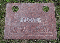
Myrtle Ann Kunkle Floyd
| Birth | : | 14 Apr 1905 Nebraska, USA |
| Death | : | 13 Jul 1987 Santa Clara County, California, USA |
| Burial | : | Saint Joseph Catholic Cemetery, San Pablo, Contra Costa County, USA |
| Coordinate | : | 37.9612700, -122.3336600 |
frequently asked questions (FAQ):
-
Where is Myrtle Ann Kunkle Floyd's memorial?
Myrtle Ann Kunkle Floyd's memorial is located at: Saint Joseph Catholic Cemetery, San Pablo, Contra Costa County, USA.
-
When did Myrtle Ann Kunkle Floyd death?
Myrtle Ann Kunkle Floyd death on 13 Jul 1987 in Santa Clara County, California, USA
-
Where are the coordinates of the Myrtle Ann Kunkle Floyd's memorial?
Latitude: 37.9612700
Longitude: -122.3336600
Family Members:
Parent


Spouse
Siblings
Flowers:


Nearby Cemetories:
1. Saint Joseph Catholic Cemetery
San Pablo, Contra Costa County, USA
Coordinate: 37.9612700, -122.3336600
2. Saint Pauls Cemetery (Defunct)
San Pablo, Contra Costa County, USA
Coordinate: 37.9563332, -122.3430099
3. Salesian Cemetery
Richmond, Contra Costa County, USA
Coordinate: 37.9532650, -122.3401230
4. Rolling Hills Memorial Park
Richmond, Contra Costa County, USA
Coordinate: 37.9756012, -122.3146973
5. Sunset View Cemetery
El Cerrito, Contra Costa County, USA
Coordinate: 37.9077721, -122.2871017
6. Golden Gate Mausoleum and Columbaria
El Cerrito, Contra Costa County, USA
Coordinate: 37.9073150, -122.2857220
7. Golden Gate Fields
Albany, Alameda County, USA
Coordinate: 37.8854000, -122.3117000
8. Northbrae Community Church Columbarium
Berkeley, Alameda County, USA
Coordinate: 37.8905500, -122.2763200
9. Gan Shalom Cemetery
Contra Costa County, USA
Coordinate: 37.9528122, -122.1975098
10. San Quentin Prison Cemetery
San Rafael, Marin County, USA
Coordinate: 37.9436480, -122.4883760
11. Angel Island Cemetery (defunct)
Tiburon, Marin County, USA
Coordinate: 37.8621830, -122.4325920
12. Rags Gravesite
Crockett, Contra Costa County, USA
Coordinate: 38.0561765, -122.2257217
13. Mare Island Cemetery
Vallejo, Solano County, USA
Coordinate: 38.0796738, -122.2527008
14. St. Stephen's Episcopal Church Memorial Garden
Belvedere, Marin County, USA
Coordinate: 37.8767515, -122.4712901
15. Saint Stephens Episcopal Church Memorial Garden
Orinda, Contra Costa County, USA
Coordinate: 37.8982650, -122.1729170
16. Saint Mary's Cemetery
Oakland, Alameda County, USA
Coordinate: 37.8349991, -122.2418976
17. Glen Cove Sacred Indian Burial Grounds
Vallejo, Solano County, USA
Coordinate: 38.0680620, -122.2064640
18. Chapel of Memories Columbarium
Oakland, Alameda County, USA
Coordinate: 37.8310471, -122.2480927
19. Home of Eternity Cemetery
Oakland, Alameda County, USA
Coordinate: 37.8322970, -122.2448270
20. Chapel of the Chimes Columbarium and Mausoleum
Oakland, Alameda County, USA
Coordinate: 37.8318863, -122.2456894
21. Mountain View Cemetery
Oakland, Alameda County, USA
Coordinate: 37.8327600, -122.2395200
22. Yerba Buena Island Cemetery (Defunct)
San Francisco, San Francisco County, USA
Coordinate: 37.8127420, -122.3707880
23. Mission San Rafael Arcangel Cemetery
San Rafael, Marin County, USA
Coordinate: 37.9744330, -122.5280570
24. Lafayette-Orinda Presbyterian Church Garden
Contra Costa County, USA
Coordinate: 37.8866040, -122.1606950