
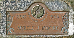
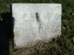
Myrtle J. Baker Moore
| Birth | : | 15 Mar 1890 Jefferson County, Iowa, USA |
| Death | : | 19 Jul 1966 Keota, Keokuk County, Iowa, USA |
| Burial | : | Saint John Cemetery, Saint Bernard, Hamilton County, USA |
| Coordinate | : | 39.1643982, -84.5053024 |
| Plot | : | Devotion B 43 - space 1 |
| Inscription | : | IN LOVING MEMORY |
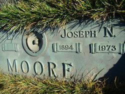
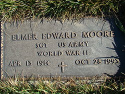
| Description | : | MYRTLE (BAKER) MOORE was born to George and Asenath (Ross) Baker on Febraury 15, 1890 in Fairfield, Iowa. Note: Richard K. Thompson states that Myrtle J. Moore was born February 15, 1890. She married Joseph N. Moore. He went by the name of Joe. Myrtle died July 19, 1966 in Keota, Iowa. To this blessed marriage were born the following children: Elmer E. Moore |
frequently asked questions (FAQ):
-
Where is Myrtle J. Baker Moore's memorial?
Myrtle J. Baker Moore's memorial is located at: Saint John Cemetery, Saint Bernard, Hamilton County, USA.
-
When did Myrtle J. Baker Moore death?
Myrtle J. Baker Moore death on 19 Jul 1966 in Keota, Keokuk County, Iowa, USA
-
Where are the coordinates of the Myrtle J. Baker Moore's memorial?
Latitude: 39.1643982
Longitude: -84.5053024
Family Members:
Parent
Spouse
Siblings

Children
Flowers:


Nearby Cemetories:
1. Saint John Cemetery
Saint Bernard, Hamilton County, USA
Coordinate: 39.1643982, -84.5053024
2. Vine Street Hill Cemetery
Cincinnati, Hamilton County, USA
Coordinate: 39.1516991, -84.5091019
3. Saint Mary Cemetery
Saint Bernard, Hamilton County, USA
Coordinate: 39.1664009, -84.4880981
4. Spring Grove Cemetery
Cincinnati, Hamilton County, USA
Coordinate: 39.1647900, -84.5231500
5. First German Protestant Cemetery
Avondale, Hamilton County, USA
Coordinate: 39.1492004, -84.4863968
6. Clifton United Jewish Cemetery
Cincinnati, Hamilton County, USA
Coordinate: 39.1470871, -84.5292816
7. Hillside Chapel Crematory and Columbarium
Cincinnati, Hamilton County, USA
Coordinate: 39.1393509, -84.5247192
8. Methodist Protestant Cemetery (Defunct)
Cincinnati, Hamilton County, USA
Coordinate: 39.1324770, -84.4983160
9. Wesleyan Cemetery
Cincinnati, Hamilton County, USA
Coordinate: 39.1599998, -84.5468979
10. Old Finneytown Cemetery
Finneytown, Hamilton County, USA
Coordinate: 39.1962220, -84.5206120
11. Walnut Hills Cemetery
Cincinnati, Hamilton County, USA
Coordinate: 39.1355950, -84.4809040
12. Walnut Hills Jewish Cemetery
Evanston, Hamilton County, USA
Coordinate: 39.1403700, -84.4731300
13. Calvary Cemetery
Cincinnati, Hamilton County, USA
Coordinate: 39.1403008, -84.4697037
14. Longview Hospital Cemetery
Roselawn, Hamilton County, USA
Coordinate: 39.1887730, -84.4691660
15. Third Quaker Cemetery (Defunct)
Cincinnati, Hamilton County, USA
Coordinate: 39.1542400, -84.5523720
16. Convent of the Good Shepherd Cemetery (Defunct)
Carthage, Hamilton County, USA
Coordinate: 39.2055250, -84.5042780
17. Bishop Cemetery (Defunct)
College Hill, Hamilton County, USA
Coordinate: 39.1910210, -84.5489570
18. Griffins Station Cemetery
Carthage, Hamilton County, USA
Coordinate: 39.2047000, -84.4770730
19. Fulton Cemetery
Hyde Park, Hamilton County, USA
Coordinate: 39.1406364, -84.4506302
20. City Infirmary Cemetery
Hartwell, Hamilton County, USA
Coordinate: 39.2123500, -84.4806700
21. Christ Church Cemetery
Over-The-Rhine, Hamilton County, USA
Coordinate: 39.1126480, -84.5157623
22. Second Quaker Cemetery (Defunct)
Cincinnati, Hamilton County, USA
Coordinate: 39.1153090, -84.5305240
23. Baltimore Pike Cemetery
Cincinnati, Hamilton County, USA
Coordinate: 39.1397018, -84.5681000
24. Gard-Brown Cemetery
North Bend, Hamilton County, USA
Coordinate: 39.2035200, -84.5553300