
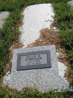
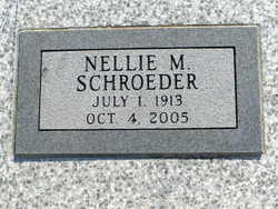
Nellie Margerite Armbruster Vaupel Schroeder
| Birth | : | 1 Jul 1913 |
| Death | : | 4 Oct 2005 |
| Burial | : | Woodlands Cemetery and Crematorium, Scarborough, Scarborough Borough, England |
| Coordinate | : | 54.2766640, -0.4428030 |
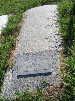
| Description | : | Obituary published in the 6 October 2005 edition of The Salina Journal. BLYTHEVILLE, Ark. -- Nellie Margerite Schroeder, 82, Blytheville, died Tuesday, Oct. 4, 2005. Mrs. Schroeder was born Nellie Margerite Armbruster on July 1, 1913, in Roxbury, Kan. She was a nurse. She was preceded in death by her first husband, Fred Vaupel; and her second husband, Leo Schroeder. Survivors include two daughters, Nellie Marie Vaupel Bowman and Fredia Mae Vaupel Glover; six grandchildren; and seven great-grandchildren. A graveside service will be at 2 p.m. Saturday in Highland Cemetery, New Cambria, Kan. There will be no visitation. Ryan Mortuary, 137 N. Eighth, Salina, KS 67401, is... Read More |
frequently asked questions (FAQ):
-
Where is Nellie Margerite Armbruster Vaupel Schroeder's memorial?
Nellie Margerite Armbruster Vaupel Schroeder's memorial is located at: Woodlands Cemetery and Crematorium, Scarborough, Scarborough Borough, England.
-
When did Nellie Margerite Armbruster Vaupel Schroeder death?
Nellie Margerite Armbruster Vaupel Schroeder death on 4 Oct 2005 in
-
Where are the coordinates of the Nellie Margerite Armbruster Vaupel Schroeder's memorial?
Latitude: 54.2766640
Longitude: -0.4428030
Family Members:
Parent
Spouse
Siblings
Flowers:


Nearby Cemetories:
1. Woodlands Cemetery and Crematorium
Scarborough, Scarborough Borough, England
Coordinate: 54.2766640, -0.4428030
2. Dean Road and Manor Road Cemetery
Scarborough, Scarborough Borough, England
Coordinate: 54.2843690, -0.4184140
3. St Laurence Churchyard
Scalby, Scarborough Borough, England
Coordinate: 54.2988160, -0.4507520
4. Greyfriars Abbey
Scarborough, Scarborough Borough, England
Coordinate: 54.2850360, -0.3950300
5. Quaker House Church
Scarborough Borough, England
Coordinate: 54.2844280, -0.3941730
6. St. Mary's Churchyard
Scarborough, Scarborough Borough, England
Coordinate: 54.2864850, -0.3936260
7. Scarborough Castle
Scarborough, Scarborough Borough, England
Coordinate: 54.2875810, -0.3895485
8. St. John the Baptist Churchyard
East Ayton, Scarborough Borough, England
Coordinate: 54.2508900, -0.4792900
9. St Martin Churchyard
Seamer, Scarborough Borough, England
Coordinate: 54.2361500, -0.4437100
10. St Peter Churchyard
Hackness, Scarborough Borough, England
Coordinate: 54.3012880, -0.5127850
11. St Matthew Churchyard
Hutton Buscel, Scarborough Borough, England
Coordinate: 54.2426410, -0.5071200
12. St. John the Baptist Churchyard
Cayton, Scarborough Borough, England
Coordinate: 54.2346470, -0.3805180
13. Cloughton Church Cemetery
Cloughton, Scarborough Borough, England
Coordinate: 54.3322500, -0.4511900
14. Cayton Cemetery
Cayton, Scarborough Borough, England
Coordinate: 54.2314030, -0.3755910
15. St. Helen’s & All Saints Churchyard
Wykeham, Scarborough Borough, England
Coordinate: 54.2372000, -0.5212000
16. St Peter Churchyard
Langdale End, Scarborough Borough, England
Coordinate: 54.3065050, -0.5557030
17. St. Peter's Churchyard
Willerby, Ryedale District, England
Coordinate: 54.1984200, -0.4558500
18. Flixton Cemetery New
Folkton, Scarborough Borough, England
Coordinate: 54.2006600, -0.3934700
19. St John The Evangelist Churchyard
Folkton, Scarborough Borough, England
Coordinate: 54.2020400, -0.3865200
20. All Saints Churchyard
Brompton-by-Sawdon, Scarborough Borough, England
Coordinate: 54.2262550, -0.5549320
21. All Saints Church Cemetery
Brompton-by-Sawdon, Scarborough Borough, England
Coordinate: 54.2223100, -0.5500900
22. St Margaret Churchyard
Harwood Dale, Scarborough Borough, England
Coordinate: 54.3470030, -0.5238540
23. St Nicholas Churchyard
Ganton, Ryedale District, England
Coordinate: 54.1846000, -0.4846000
24. St Margaret Churchyard (Ruins)
Harwood Dale, Scarborough Borough, England
Coordinate: 54.3558170, -0.5365790