

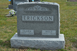
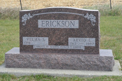
Nels Erickson
| Birth | : | 10 Jun 1871 Bollnas, Bollnäs kommun, Gävleborgs län, Sweden |
| Death | : | 27 Nov 1942 Stratford, Hamilton County, Iowa, USA |
| Burial | : | South Marion Cemetery, Stratford, Hamilton County, USA |
| Coordinate | : | 42.2327995, -93.8735962 |
| Description | : | Stratford Courier December 3, 1942 Obituary Nels Erickson Nels Erickson, prominent farmer of this community, died in his home five and three-quarters miles northeast of Stratford, Friday evening after a lingering illness. Funeral rites were held Monday afternoon at 2 o'clock in the Baptist church following a service in the family home at 1:15 o'clock. Both were in charge of the Rev. James Selander, the pastor. At the church service the pastor used for his text, John 14:1,2. Mrs. LeRoy Fisher and Mrs. Oscar Borg, with Mrs. James Selander playing the accompaniments, sang "Ivory Palaces" and "City Four Square." Burial rites were in the South Marion... Read More |
frequently asked questions (FAQ):
-
Where is Nels Erickson's memorial?
Nels Erickson's memorial is located at: South Marion Cemetery, Stratford, Hamilton County, USA.
-
When did Nels Erickson death?
Nels Erickson death on 27 Nov 1942 in Stratford, Hamilton County, Iowa, USA
-
Where are the coordinates of the Nels Erickson's memorial?
Latitude: 42.2327995
Longitude: -93.8735962
Family Members:
Parent

Spouse
Siblings
Children
Flowers:


Nearby Cemetories:
1. South Marion Cemetery
Stratford, Hamilton County, USA
Coordinate: 42.2327995, -93.8735962
2. Oakwood Cemetery
Stratford, Hamilton County, USA
Coordinate: 42.2942009, -93.9182968
3. Mineral Ridge Cemetery
Ridgeport, Boone County, USA
Coordinate: 42.1749992, -93.9266968
4. Hooks Point Cemetery
Hamilton County, USA
Coordinate: 42.2944530, -93.9199090
5. Hardin Township Cemetery
Hardin Township, Webster County, USA
Coordinate: 42.2411003, -93.9708023
6. Saint Paul Lutheran Cemetery
Boone, Boone County, USA
Coordinate: 42.1700000, -93.8070000
7. Boone County Poor Farm Cemetery
Boone County, USA
Coordinate: 42.1591100, -93.9159000
8. White Cemetery
Boone County, USA
Coordinate: 42.1777992, -93.9636002
9. Lake Center Cemetery
Stanhope, Hamilton County, USA
Coordinate: 42.2482986, -93.7568970
10. Leininger Cemetery
Boone County, USA
Coordinate: 42.1492004, -93.8356018
11. Lawn Hill Cemetery
Stanhope, Hamilton County, USA
Coordinate: 42.2677994, -93.7611008
12. Nesse Cemetery
Hamilton County, USA
Coordinate: 42.3250008, -93.8933029
13. Neese Cemetery
Homer, Hamilton County, USA
Coordinate: 42.3250000, -93.8935000
14. Linn Cemetery
Pilot Mound, Boone County, USA
Coordinate: 42.2045330, -93.9970230
15. Vegors Cemetery
Webster County, USA
Coordinate: 42.3177986, -93.9421997
16. Mackey Cemetery
Boone County, USA
Coordinate: 42.1675000, -93.7565000
17. Runyan Cemetery
Pilot Mound, Boone County, USA
Coordinate: 42.1749992, -94.0015030
18. Saint Pauls Church Cemetery
Jewell, Hamilton County, USA
Coordinate: 42.2490100, -93.7173400
19. Schlicht Cemetery
Fraser, Boone County, USA
Coordinate: 42.1444200, -93.9780100
20. Bass Cemetery
Dayton, Webster County, USA
Coordinate: 42.2966995, -94.0149994
21. Saratoga Cemetery
Stanhope, Hamilton County, USA
Coordinate: 42.3539009, -93.8167038
22. Pilot Mound Cemetery
Pilot Mound, Boone County, USA
Coordinate: 42.1636200, -94.0282600
23. Ellsworth Clear Lake Cemetery
Randall, Hamilton County, USA
Coordinate: 42.2268930, -93.6926200
24. Bass Point Cemetery
Boone, Boone County, USA
Coordinate: 42.0992012, -93.8957977