
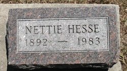
Nettie Holloway Hesse
| Birth | : | 24 Jan 1892 Linden, Dallas County, Iowa, USA |
| Death | : | 16 Sep 1983 Gooding, Gooding County, Idaho, USA |
| Burial | : | Fort Calhoun Cemetery, Fort Calhoun, Washington County, USA |
| Coordinate | : | 41.4581375, -96.0352020 |
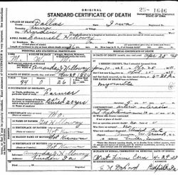
| Description | : | Published in The Times (Twin Falls, Idaho), Sunday, 18 Sep 1983, p. 12: HAGERMAN — Nettie Hesse, 91, of Hagerman, died Friday morning at the Green Acres Care Center in Gooding. Born Jan. 24, 1892, in Linden, Iowa, she grew up and was educated there. She married Everett E. Hesse on July 24, 1918 in Chillicothe, Mo., and they lived in Iowa until moving in 1927 to Hagerman, where they have lived since. Surviving are: two daughters, Dorothy Hendrickson of Hagerman, and Jean Dickerson of Pocatello; two sons, John Hesse of Guthrie Center, Iowa, and Howard Hesse... Read More |
frequently asked questions (FAQ):
-
Where is Nettie Holloway Hesse's memorial?
Nettie Holloway Hesse's memorial is located at: Fort Calhoun Cemetery, Fort Calhoun, Washington County, USA.
-
When did Nettie Holloway Hesse death?
Nettie Holloway Hesse death on 16 Sep 1983 in Gooding, Gooding County, Idaho, USA
-
Where are the coordinates of the Nettie Holloway Hesse's memorial?
Latitude: 41.4581375
Longitude: -96.0352020
Family Members:
Parent
Spouse
Siblings
Children
Flowers:


Nearby Cemetories:
1. Fort Calhoun Cemetery
Fort Calhoun, Washington County, USA
Coordinate: 41.4581375, -96.0352020
2. Pioneer Memorial Cemetery
Fort Calhoun, Washington County, USA
Coordinate: 41.4472008, -96.0971985
3. Wilcox Cemetery
Fort Calhoun, Washington County, USA
Coordinate: 41.4509380, -96.1098340
4. Shipley Cemetery
Washington County, USA
Coordinate: 41.3932991, -95.9828033
5. German Cemetery
Washington County, USA
Coordinate: 41.4150600, -96.1366900
6. Union Memorial Cemetery
Omaha, Douglas County, USA
Coordinate: 41.3512611, -96.0620193
7. Holy Cross Cemetery
Blair, Washington County, USA
Coordinate: 41.5493600, -96.1187700
8. Blair Cemetery
Blair, Washington County, USA
Coordinate: 41.5508003, -96.1185989
9. Blair Potters Field
Washington County, USA
Coordinate: 41.5521900, -96.1179000
10. Saint Marys Episcopal Church Columbarium
Blair, Washington County, USA
Coordinate: 41.5419239, -96.1379580
11. Crook Cemetery
Honey Creek, Pottawattamie County, USA
Coordinate: 41.4581330, -95.8737000
12. Prayer Garden at First Lutheran Church
Blair, Washington County, USA
Coordinate: 41.5504880, -96.1452950
13. Potter Field
Omaha, Douglas County, USA
Coordinate: 41.3320274, -95.9902878
14. Branson Cemetery
Loveland, Pottawattamie County, USA
Coordinate: 41.4846992, -95.8606033
15. Mormon Pioneer Cemetery
Omaha, Douglas County, USA
Coordinate: 41.3348450, -95.9663720
16. Kennard Cemetery
Kennard, Washington County, USA
Coordinate: 41.4738998, -96.2138977
17. Allen Cemetery
Pottawattamie County, USA
Coordinate: 41.4427986, -95.8550034
18. Forest Lawn Memorial Park
Omaha, Douglas County, USA
Coordinate: 41.3272018, -95.9847031
19. Brewster Cemetery
Kennard, Washington County, USA
Coordinate: 41.5088250, -96.2042950
20. Kobs Pioneer Cemetery
Bennington, Douglas County, USA
Coordinate: 41.3453000, -96.1389000
21. Oak Grove Cemetery
Missouri Valley, Harrison County, USA
Coordinate: 41.5167007, -95.8649979
22. Prairie View Cemetery
Washington, Washington County, USA
Coordinate: 41.4225006, -96.2241974
23. Pleasant Hill Jewish Cemetery
Omaha, Douglas County, USA
Coordinate: 41.3185997, -95.9766998
24. Mount Sinai Cemetery
Omaha, Douglas County, USA
Coordinate: 41.3116989, -96.0314026