
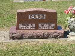
Nettie Lowe Carr
| Birth | : | 19 Aug 1883 Hannibal, Marion County, Missouri, USA |
| Death | : | 2 Oct 1968 Rochester, Fulton County, Indiana, USA |
| Burial | : | Calvary Catholic Cemetery, Petaluma, Sonoma County, USA |
| Coordinate | : | 38.2449000, -122.6493400 |
| Description | : | Wednesday, October 2, 1968 Rochester Sentinel Fulton County, Indiana Nettie Carr Mrs. Nettie CARR, 85, 118 West Fifth street, died at 1:30 p.m. Tuesday in Woodlawn hospital where she had been a patient since Sept. 15. She had been ill three Years and serious two weeks. A lifetime resident of Rochester, she was born Aug. 19, 1883, in Hannibal, Mo. the daugher of John and Ida JOLIFF LOWE. Her marriage was Oct. 31, 1908, in Rochester, to Fred S. CARR. He died Feb. 14, 1946. Mrs. Carr was a member of the Trinity United Methodist Church of Rochester and the Mo thers of... Read More |
frequently asked questions (FAQ):
-
Where is Nettie Lowe Carr's memorial?
Nettie Lowe Carr's memorial is located at: Calvary Catholic Cemetery, Petaluma, Sonoma County, USA.
-
When did Nettie Lowe Carr death?
Nettie Lowe Carr death on 2 Oct 1968 in Rochester, Fulton County, Indiana, USA
-
Where are the coordinates of the Nettie Lowe Carr's memorial?
Latitude: 38.2449000
Longitude: -122.6493400
Family Members:
Parent

Spouse

Siblings
Children
Flowers:


Nearby Cemetories:
1. Calvary Catholic Cemetery
Petaluma, Sonoma County, USA
Coordinate: 38.2449000, -122.6493400
2. B'nai Israel Cemetery
Petaluma, Sonoma County, USA
Coordinate: 38.2454700, -122.6490000
3. Cypress Hill Memorial Park
Petaluma, Sonoma County, USA
Coordinate: 38.2472000, -122.6505966
4. My Pets Cemetery
Petaluma, Sonoma County, USA
Coordinate: 38.2472000, -122.6506000
5. Oak Hill Cemetery
Petaluma, Sonoma County, USA
Coordinate: 38.2365130, -122.6509010
6. General Vallejo Ranch Cemetery
Sonoma, Sonoma County, USA
Coordinate: 38.2554500, -122.5845200
7. Liberty Cemetery
Petaluma, Sonoma County, USA
Coordinate: 38.2781990, -122.7055500
8. Two Rock Presbyterian Church Cemetery
Two Rock, Sonoma County, USA
Coordinate: 38.2570000, -122.7795029
9. Sonoma State Home Cemetery
Eldridge, Sonoma County, USA
Coordinate: 38.3412190, -122.5427810
10. Faith Lutheran Church Memorial Garden
Sonoma, Sonoma County, USA
Coordinate: 38.2932380, -122.4880690
11. Thompson Family Cemetery
Glen Ellen, Sonoma County, USA
Coordinate: 38.3644240, -122.5621210
12. Pioneer Memorial Cemetery
Novato, Marin County, USA
Coordinate: 38.1132532, -122.5902599
13. Jack London State Historic Park Cemetery
Glen Ellen, Sonoma County, USA
Coordinate: 38.3538000, -122.5367000
14. Valley Memorial Park
Novato, Marin County, USA
Coordinate: 38.1204300, -122.5436300
15. Macedonia Methodist Episcopal Church Cemetery
Sebastopol, Sonoma County, USA
Coordinate: 38.3594860, -122.7727270
16. Mission San Francisco Solano Cemetery
Sonoma, Sonoma County, USA
Coordinate: 38.2937164, -122.4561844
17. Sonoma Veterans Cemetery
Sonoma, Sonoma County, USA
Coordinate: 38.2992790, -122.4566390
18. Valley Cemetery
Sonoma, Sonoma County, USA
Coordinate: 38.2832985, -122.4496994
19. Trinity Episcopal Church Columbarium
Sonoma, Sonoma County, USA
Coordinate: 38.2930390, -122.4521650
20. Mountain Cemetery
Sonoma, Sonoma County, USA
Coordinate: 38.3008003, -122.4535980
21. Saint Francis Solano Cemetery
Sonoma, Sonoma County, USA
Coordinate: 38.2915993, -122.4459991
22. Canfield Cemetery
Sebastopol, Sonoma County, USA
Coordinate: 38.3512430, -122.8147040
23. Bennett Valley Cemetery
Santa Rosa, Sonoma County, USA
Coordinate: 38.4161987, -122.6619034
24. Chapel of the Chimes Cemetery and Mausoleum
Santa Rosa, Sonoma County, USA
Coordinate: 38.4141998, -122.7137985