
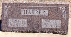
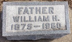
Noah Manford Harper
| Birth | : | 3 Feb 1861 Blairstown, Benton County, Iowa, USA |
| Death | : | Jun 1941 Glasco, Cloud County, Kansas, USA |
| Burial | : | Glasco Cemetery, Glasco, Cloud County, USA |
| Coordinate | : | 39.3574000, -97.8265000 |
| Description | : | Glasco Sun, June 11, 1941, page 1: N. H. HARPER OBITUARY Noah Manford, son of Samuel Alexander and Nancy Pasco Harper, was born February 3, 1861 near Blairstown, Benton County, Iowa. He was the second of six children of whom three survive. With the family he moved to Kansas and in December 1878 they settled in the community near the present family home. On March 11, 1886, he was united in marriage to Mary Elizabeth Brown, who passed from this life on February 26, 1919. To this union were born eight children, three sons and five daughters. One son and two... Read More |
frequently asked questions (FAQ):
-
Where is Noah Manford Harper's memorial?
Noah Manford Harper's memorial is located at: Glasco Cemetery, Glasco, Cloud County, USA.
-
When did Noah Manford Harper death?
Noah Manford Harper death on Jun 1941 in Glasco, Cloud County, Kansas, USA
-
Where are the coordinates of the Noah Manford Harper's memorial?
Latitude: 39.3574000
Longitude: -97.8265000
Family Members:
Parent
Spouse

Siblings
Children

Flowers:


Nearby Cemetories:
1. Glasco Cemetery
Glasco, Cloud County, USA
Coordinate: 39.3574000, -97.8265000
2. Saint Marys Catholic Cemetery
Glasco, Cloud County, USA
Coordinate: 39.3574000, -97.8245000
3. Simpson Cemetery
Simpson, Mitchell County, USA
Coordinate: 39.3633003, -97.9471970
4. Bethel Cemetery
Meredith Township, Cloud County, USA
Coordinate: 39.3506000, -97.7029000
5. Delphos Cemetery
Delphos, Ottawa County, USA
Coordinate: 39.2778015, -97.7416992
6. Saint Paul Cemetery
Delphos, Ottawa County, USA
Coordinate: 39.2677994, -97.7518997
7. Asherville Cemetery
Asherville, Mitchell County, USA
Coordinate: 39.4205000, -97.9672900
8. Morrison Cemetery
Center Township, Cloud County, USA
Coordinate: 39.4817009, -97.7975006
9. Summit Cemetery
Jamestown, Cloud County, USA
Coordinate: 39.4813200, -97.8628800
10. Green Mound Cemetery
Asherville, Mitchell County, USA
Coordinate: 39.3203011, -97.9858017
11. Coursen Grove Cemetery
Simpson, Mitchell County, USA
Coordinate: 39.3060989, -97.9792023
12. Hall Cemetery
Cloud County, USA
Coordinate: 39.4455986, -97.7033005
13. Saint Peters Cemetery
Miltonvale, Cloud County, USA
Coordinate: 39.3652350, -97.6483570
14. Bell-Bogardus Cemetery
Asherville, Mitchell County, USA
Coordinate: 39.4242410, -97.9919970
15. Bohemian National Cemetery
Ada, Ottawa County, USA
Coordinate: 39.2193870, -97.9054030
16. Wilcox Cemetery
Cloud County, USA
Coordinate: 39.4925003, -97.7313995
17. West Asher Cemetery
Scottsville, Mitchell County, USA
Coordinate: 39.4815000, -97.9661600
18. Baldwin Cemetery
Ottawa County, USA
Coordinate: 39.2061005, -97.9111023
19. Kindel Cemetery
Center Township, Cloud County, USA
Coordinate: 39.4519005, -97.6464005
20. Smith Cemetery
Asherville, Mitchell County, USA
Coordinate: 39.4516690, -98.0098850
21. McBride Cemetery
Beloit, Mitchell County, USA
Coordinate: 39.4808006, -97.9907990
22. Enterprise Cemetery
Cloud County, USA
Coordinate: 39.4230995, -97.6106033
23. Shiloh Cemetery
Beloit, Mitchell County, USA
Coordinate: 39.3574982, -98.0594025
24. Summit Cemetery #3
Macyville, Cloud County, USA
Coordinate: 39.5258330, -97.9194440