
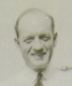
Oliver Julius “Ollie” Diel
| Birth | : | 13 Aug 1912 St. Louis City, Missouri, USA |
| Death | : | 4 Mar 1991 Salinas Municipality, Puerto Rico, USA |
| Burial | : | Garden of Memories, Salinas, Monterey County, USA |
| Coordinate | : | 36.6565247, -121.6384125 |
| Description | : | Oliver J "Ollie" Diel of Salinas died Monday at Natividad Medical Center after an apparent heart attack. He was 78. A native of St Louis, Mr. Diel lived in Salinas 43 years. He was a retired mens apparel salesman and a member of Disabled American Veterans Post 101 and Salinas American Legion Post No 31. He served in the US Navy during World War II. Mr. Diel is survived by his wife, Thelma Diel of Salinas. No funeral services are planned. Inurnment will be in the Garden of Memories. |
frequently asked questions (FAQ):
-
Where is Oliver Julius “Ollie” Diel's memorial?
Oliver Julius “Ollie” Diel's memorial is located at: Garden of Memories, Salinas, Monterey County, USA.
-
When did Oliver Julius “Ollie” Diel death?
Oliver Julius “Ollie” Diel death on 4 Mar 1991 in Salinas Municipality, Puerto Rico, USA
-
Where are the coordinates of the Oliver Julius “Ollie” Diel's memorial?
Latitude: 36.6565247
Longitude: -121.6384125
Family Members:
Spouse

Flowers:


Nearby Cemetories:
1. Garden of Memories
Salinas, Monterey County, USA
Coordinate: 36.6565247, -121.6384125
2. Yamato Cemetery
Salinas, Monterey County, USA
Coordinate: 36.6552811, -121.6307297
3. Saint Pauls Episcopal Church Columbarium
Salinas, Monterey County, USA
Coordinate: 36.6588430, -121.6558850
4. Chinese Cemetery
Salinas, Monterey County, USA
Coordinate: 36.6952057, -121.6390381
5. Monterey County Potters Field Cemetery
Salinas, Monterey County, USA
Coordinate: 36.6960900, -121.6381950
6. Calvary Catholic Cemetery
Salinas, Monterey County, USA
Coordinate: 36.6880341, -121.6818085
7. Saint Georges Episcopal Church Columbarium
Salinas, Monterey County, USA
Coordinate: 36.7062580, -121.6440980
8. Santa Rita Chapel and Cemetery
Salinas, Monterey County, USA
Coordinate: 36.7281303, -121.6565475
9. Whitcher Cemetery
East Garrison, Monterey County, USA
Coordinate: 36.6501730, -121.7305270
10. Queen of Heaven Cemetery
Prunedale, Monterey County, USA
Coordinate: 36.7602425, -121.6611252
11. California Central Coast Veterans Cemetery
Seaside, Monterey County, USA
Coordinate: 36.6371900, -121.7963600
12. Church of the Good Shepherd Cemetery
Salinas, Monterey County, USA
Coordinate: 36.5413990, -121.7260410
13. Mission Memorial Park
Seaside, Monterey County, USA
Coordinate: 36.6191635, -121.8217926
14. Monterey Bay Loved Pet Cemetery
Monterey County, USA
Coordinate: 36.8326160, -121.6812820
15. Castroville Public Cemetery
Moss Landing, Monterey County, USA
Coordinate: 36.7930145, -121.7851410
16. Hambey Cemetery
Monterey County, USA
Coordinate: 36.8372002, -121.6793976
17. Stephen Norriss Gravesite
Monterey County, USA
Coordinate: 36.8214110, -121.7601080
18. Saint Dunstans Episcopal Church Columbarium
Carmel Valley, Monterey County, USA
Coordinate: 36.5197330, -121.8059160
19. San Juan Bautista Cemetery
San Juan Bautista, San Benito County, USA
Coordinate: 36.8457985, -121.5438995
20. Monterey City Cemetery
Monterey, Monterey County, USA
Coordinate: 36.5954475, -121.8845215
21. Mission San Juan Bautista Cemetery
San Juan Bautista, San Benito County, USA
Coordinate: 36.8460007, -121.5339966
22. San Carlos Cemetery
Monterey, Monterey County, USA
Coordinate: 36.5951881, -121.8871460
23. Mission San Carlos Cemetery
Monterey, Monterey County, USA
Coordinate: 36.5956078, -121.8904190
24. Alexis Nino Burial Site
Monterey, Monterey County, USA
Coordinate: 36.6055565, -121.8955307