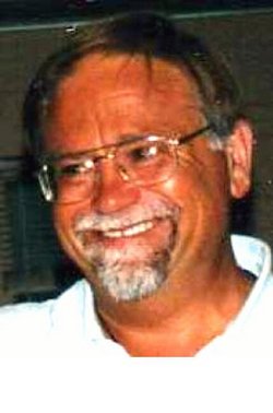
Paul Alfred Wirkler
| Birth | : | 8 Oct 1954 Guttenberg, Clayton County, Iowa, USA |
| Death | : | 1 Jan 2007 Prairie du Chien, Crawford County, Wisconsin, USA |
| Burial | : | General Cemetery, Nottingham, Nottingham Unitary Authority, England |
| Coordinate | : | 52.9561430, -1.1615420 |
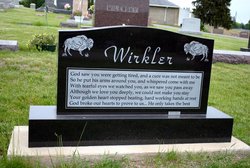
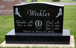
| Inscription | : | Wirkler Claudia M. Dec. 4, 1960 Paul A. Oct. 8, 1954 Jan. 1, 2007 [married] Dec. 23, 1980 Parents of Steven and Shelly |
| Description | : | Obituary from the "Telegraph Herald" of Dubuque, Iowa dated 4 Jan 2007: Paul Alfred Wirkler, 52, of Garnavillo died Monday, Jan. 1, 2007, at Prairie du Chien Memorial Hospital in Prairie du Chien, Wis., following a sudden illness. Visitation was Thursday, Jan. 4, 2007 at Tuecke-Allyn Funeral Home, Garnavillo. Funeral services were Friday, Jan. 5, 2007, at the Tuecke-Allyn Funeral Home in Garnavillo. Interment was at the Garnavillo Community Cemetery. Casket bearers were Daniel Wirkler, Ryan Wirkler, David Wirkler, Robert Wirkler, John Wirkler and Don Wirkler. Paul Alfred Wirkler was born Oct. 8, 1954,... Read More |
frequently asked questions (FAQ):
-
Where is Paul Alfred Wirkler's memorial?
Paul Alfred Wirkler's memorial is located at: General Cemetery, Nottingham, Nottingham Unitary Authority, England.
-
When did Paul Alfred Wirkler death?
Paul Alfred Wirkler death on 1 Jan 2007 in Prairie du Chien, Crawford County, Wisconsin, USA
-
Where are the coordinates of the Paul Alfred Wirkler's memorial?
Latitude: 52.9561430
Longitude: -1.1615420
Family Members:
Parent
Spouse
Siblings
Flowers:
Nearby Cemetories:
1. General Cemetery
Nottingham, Nottingham Unitary Authority, England
Coordinate: 52.9561430, -1.1615420
2. Nottingham General Cemetery
Nottingham, Nottingham Unitary Authority, England
Coordinate: 52.9575370, -1.1594236
3. Cathedral Church of St. Barnabas
Nottingham, Nottingham Unitary Authority, England
Coordinate: 52.9546750, -1.1570460
4. Hardy Street Jewish Cemetery
Nottingham, Nottingham Unitary Authority, England
Coordinate: 52.9619500, -1.1665900
5. St Nicholas Churchyard
Nottingham, Nottingham Unitary Authority, England
Coordinate: 52.9504780, -1.1509220
6. St Peters Church Yard
Nottingham, Nottingham Unitary Authority, England
Coordinate: 52.9522800, -1.1486940
7. Nottingham Church Cemetery
Nottingham, Nottingham Unitary Authority, England
Coordinate: 52.9649830, -1.1558070
8. Holy Trinity Churchyard
Lenton, Nottingham Unitary Authority, England
Coordinate: 52.9485630, -1.1753148
9. St. Peter Churchyard Old Radford
Nottingham, Nottingham Unitary Authority, England
Coordinate: 52.9601830, -1.1789620
10. National Justice Museum High Pavement Nottingham
Nottingham Unitary Authority, England
Coordinate: 52.9510680, -1.1443050
11. St Mary's Burial Grounds
Nottingham, Nottingham Unitary Authority, England
Coordinate: 52.9527860, -1.1419160
12. St. Mary Rest Ground
Nottingham, Nottingham Unitary Authority, England
Coordinate: 52.9568310, -1.1406580
13. National Ice Centre
Nottingham, Nottingham Unitary Authority, England
Coordinate: 52.9527790, -1.1394460
14. St. John's Carrington Churchyard
Nottingham, Nottingham Unitary Authority, England
Coordinate: 52.9755350, -1.1506790
15. St. Wilfrid Churchyard
Wilford, Nottingham Unitary Authority, England
Coordinate: 52.9346290, -1.1587770
16. Wilford Village Cemetery
Wilford, Nottingham Unitary Authority, England
Coordinate: 52.9338540, -1.1591170
17. Basford Cemetery
Old Basford, Nottingham Unitary Authority, England
Coordinate: 52.9799700, -1.1725900
18. St. Leodegarius Churchyard
Old Basford, Nottingham Unitary Authority, England
Coordinate: 52.9794240, -1.1778650
19. St. Paul's Churchyard
Nottingham Unitary Authority, England
Coordinate: 52.9667590, -1.1172140
20. St. Giles's Church & Churchyard
West Bridgford, Rushcliffe Borough, England
Coordinate: 52.9316460, -1.1288450
21. St. Leonard's Churchyard
Wollaton, Nottingham Unitary Authority, England
Coordinate: 52.9529790, -1.2200830
22. Wollaton Cemetery
Wollaton, Nottingham Unitary Authority, England
Coordinate: 52.9503000, -1.2260800
23. Beeston Baptist Chapel
Beeston, Broxtowe Borough, England
Coordinate: 52.9246600, -1.2122000
24. Carlton Cemetery
Nottingham, Nottingham Unitary Authority, England
Coordinate: 52.9682820, -1.0900230

