
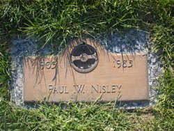
Paul William Nisley
| Birth | : | 29 Oct 1903 Nebraska, USA |
| Death | : | Jul 1985 Nebraska, USA |
| Burial | : | St Mary Churchyard, Penwortham, South Ribble Borough, England |
| Coordinate | : | 53.7551800, -2.7234210 |
frequently asked questions (FAQ):
-
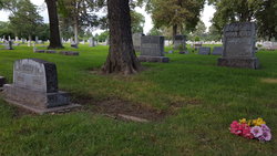
Where is Paul William Nisley's memorial?
Paul William Nisley's memorial is located at: St Mary Churchyard, Penwortham, South Ribble Borough, England.
-
When did Paul William Nisley death?
Paul William Nisley death on Jul 1985 in Nebraska, USA
-
Where are the coordinates of the Paul William Nisley's memorial?
Latitude: 53.7551800
Longitude: -2.7234210
Family Members:
Parent
Spouse
Siblings


Children
Flowers:


Nearby Cemetories:
1. St Mary Churchyard
Penwortham, South Ribble Borough, England
Coordinate: 53.7551800, -2.7234210
2. Christ Church Churchyard
Preston, City of Preston, England
Coordinate: 53.7573210, -2.7103080
3. St Walburge's RC Church
Preston, City of Preston, England
Coordinate: 53.7629690, -2.7149620
4. Penwortham Cemetery
Penwortham, South Ribble Borough, England
Coordinate: 53.7452590, -2.7209190
5. Grey Friars' Church
Preston, City of Preston, England
Coordinate: 53.7601480, -2.7084600
6. St. Wilfrid's Catholic Cemetery
Preston, City of Preston, England
Coordinate: 53.7581670, -2.7044930
7. Saint Peter Churchyard
Preston, City of Preston, England
Coordinate: 53.7634100, -2.7080700
8. St. George the Martyr
Preston, City of Preston, England
Coordinate: 53.7591220, -2.7025660
9. Friends Meeting House Burial Ground (Defunct)
Preston, City of Preston, England
Coordinate: 53.7610250, -2.7030380
10. Holy Trinity
Preston, City of Preston, England
Coordinate: 53.7613030, -2.7030580
11. St. Andrew's Churchyard
Ashton-on-Ribble, City of Preston, England
Coordinate: 53.7687030, -2.7359180
12. St John Churchyard
Preston, City of Preston, England
Coordinate: 53.7582080, -2.6959750
13. St. James' Churchyard
Preston, City of Preston, England
Coordinate: 53.7566010, -2.6941110
14. St. Ignatius RC Churchyard
Preston, City of Preston, England
Coordinate: 53.7635270, -2.6965870
15. St. Paul Churchyard
Preston, City of Preston, England
Coordinate: 53.7625360, -2.6947080
16. St Augustine of Canterbury
Preston, City of Preston, England
Coordinate: 53.7560420, -2.6912650
17. Christ Church Churchyard
Fulwood, City of Preston, England
Coordinate: 53.7771920, -2.7028700
18. Our Lady and Saint Gerards Churchyard
Lostock Hall, South Ribble Borough, England
Coordinate: 53.7279090, -2.6921460
19. St Leonard Churchyard
Walton-le-Dale, South Ribble Borough, England
Coordinate: 53.7476530, -2.6666950
20. St Paul Churchyard
Farington, South Ribble Borough, England
Coordinate: 53.7199900, -2.7017200
21. Preston Old Cemetery
Ribbleton, City of Preston, England
Coordinate: 53.7686352, -2.6623154
22. St Andrew George Haydock Roman Catholic Churchyard
Cottam, City of Preston, England
Coordinate: 53.7879280, -2.7591570
23. Preston New Cemetery
Ribbleton, City of Preston, England
Coordinate: 53.7717400, -2.6620900
24. St Mary's Churchyard Brownedge
Bamber Bridge, South Ribble Borough, England
Coordinate: 53.7305472, -2.6669416