

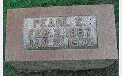
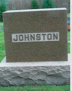
Pearl E Hall Johnston
| Birth | : | 2 Feb 1887 Adams Township, Keokuk County, Iowa, USA |
| Death | : | 21 Jan 1972 Kirkland, King County, Washington, USA |
| Burial | : | Fairview Cemetery, Smith Center, Smith County, USA |
| Coordinate | : | 39.7966995, -98.7881012 |
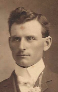
| Description | : | Pearl Johnston age 85 passed away in Kirkland, Washington. Burial in the Goldenrod Cemetery Deep River, Iowa. Pearl E Hall was the daughter of James and Alfaretta Wilson Hall. She spent her early life in the What Cheer, Iowa community. She was married to Henry C Johnston March 1, 1905. To this union one son was born; James Richard. They resided on a farm near Barnes City, Iowa for one year. They moved to Henry's home place north of Deep River, Iowa where they resided for many years, later they moved to What Cheer, Iowa where they lived... Read More |
frequently asked questions (FAQ):
-
Where is Pearl E Hall Johnston's memorial?
Pearl E Hall Johnston's memorial is located at: Fairview Cemetery, Smith Center, Smith County, USA.
-
When did Pearl E Hall Johnston death?
Pearl E Hall Johnston death on 21 Jan 1972 in Kirkland, King County, Washington, USA
-
Where are the coordinates of the Pearl E Hall Johnston's memorial?
Latitude: 39.7966995
Longitude: -98.7881012
Family Members:
Parent
Spouse
Flowers:


Nearby Cemetories:
1. Fairview Cemetery
Smith Center, Smith County, USA
Coordinate: 39.7966995, -98.7881012
2. Pleasant View Cemetery
Athol, Smith County, USA
Coordinate: 39.7859000, -98.8982000
3. Meade Cemetery
Reamsville, Smith County, USA
Coordinate: 39.8680992, -98.8839035
4. Saint John Lutheran Cemetery
Athol, Smith County, USA
Coordinate: 39.7269900, -98.8971600
5. Zion Cemetery
Athol, Smith County, USA
Coordinate: 39.8434100, -98.9171700
6. William Nelson Gravesite
Athol, Smith County, USA
Coordinate: 39.8866080, -98.8708130
7. Christ Cemetery
Gaylord, Smith County, USA
Coordinate: 39.6988100, -98.8556700
8. Custer Cemetery
Bellaire, Smith County, USA
Coordinate: 39.7350115, -98.6545141
9. Spring Vale Cemetery
Washington Township, Smith County, USA
Coordinate: 39.9154700, -98.7424900
10. Cedar Hill Cemetery
Cora, Smith County, USA
Coordinate: 39.8863200, -98.6550000
11. Crystal Plains Cemetery
Smith Center, Smith County, USA
Coordinate: 39.6909714, -98.6730270
12. Oak Hill Cemetery
Lebanon, Smith County, USA
Coordinate: 39.8437010, -98.6186200
13. Gaylord Cemetery
Gaylord, Smith County, USA
Coordinate: 39.6598300, -98.8416700
14. Parse Homestead Cemetery
Bellaire, Smith County, USA
Coordinate: 39.7269800, -98.6245300
15. Price Cemetery
Oak Township, Smith County, USA
Coordinate: 39.7986860, -98.5993060
16. Eminence Cemetery
Thornburg, Smith County, USA
Coordinate: 39.9432983, -98.8005981
17. Reamsville Methodist Church Cemetery
Reamsville, Smith County, USA
Coordinate: 39.9299500, -98.8693970
18. Reamsville Cemetery
Reamsville, Smith County, USA
Coordinate: 39.9441500, -98.8593500
19. Bell Cemetery
Smith Center, Smith County, USA
Coordinate: 39.6477700, -98.7102200
20. Cedar Cemetery
Cedar, Smith County, USA
Coordinate: 39.6685982, -98.9310989
21. Old Harlan Cemetery
Harlan, Smith County, USA
Coordinate: 39.6153520, -98.7632390
22. Pleasant Hill Cemetery
Reamsville, Smith County, USA
Coordinate: 39.9510994, -98.9175034
23. Sweet Home Cemetery
Lebanon, Smith County, USA
Coordinate: 39.7854830, -98.5465380
24. Womer Cemetery
Womer, Smith County, USA
Coordinate: 39.9736400, -98.7110800