
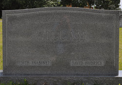
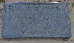
Pearl Edith “Edie” Inabinet Gillam
| Birth | : | 18 Jun 1918 Orangeburg County, South Carolina, USA |
| Death | : | 25 May 2010 South Carolina, USA |
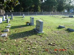
| Burial | : | Southwell Minster Churchyard, Southwell, Newark and Sherwood District, England |
| Coordinate | : | 53.0735100, -0.9524500 |
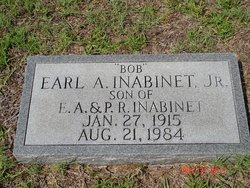
| Description | : | She was the daughter of the late Earl Alva Inabinet and Pearl Robinson Inabinet. She was a member of First Baptist Church of Orangeburg for 62 years, where she was active in the choir, Sunday school and nursery. In recent years, she returned her membership to Limestone United Methodist Church. She served many years in the Orangeburg Fire Department's Women's Auxiliary. She was predeceased by her husband, David Hydrick Gillam, Jr.; a brother, Earl A. Inabinet, Jr.; and a sister, Mary Neal Inabinet Culler. She is survived by a son and daughter-in-law, David E. and Harriet Gillam of Orangeburg; a daughter and... Read More |
frequently asked questions (FAQ):
-
Where is Pearl Edith “Edie” Inabinet Gillam's memorial?
Pearl Edith “Edie” Inabinet Gillam's memorial is located at: Southwell Minster Churchyard, Southwell, Newark and Sherwood District, England.
-
When did Pearl Edith “Edie” Inabinet Gillam death?
Pearl Edith “Edie” Inabinet Gillam death on 25 May 2010 in South Carolina, USA
-
Where are the coordinates of the Pearl Edith “Edie” Inabinet Gillam's memorial?
Latitude: 53.0735100
Longitude: -0.9524500
Family Members:
Parent
Spouse
Siblings

Children

Flowers:


Nearby Cemetories:
1. Southwell Minster Churchyard
Southwell, Newark and Sherwood District, England
Coordinate: 53.0735100, -0.9524500
2. St Michael the Archangel Churchyard
Halam, Newark and Sherwood District, England
Coordinate: 53.0822150, -0.9891350
3. St Denis Churchyard
Morton, Newark and Sherwood District, England
Coordinate: 53.0545100, -0.9168100
4. St Peter & St Paul's Churchyard
Upton, Newark and Sherwood District, England
Coordinate: 53.0805800, -0.9014900
5. Holy Trinity Churchyard
Rolleston, Newark and Sherwood District, England
Coordinate: 53.0646500, -0.8944500
6. St Mary's Churchyard
Bleasby, Newark and Sherwood District, England
Coordinate: 53.0386900, -0.9310700
7. St Giles Churchyard
Edingley, Newark and Sherwood District, England
Coordinate: 53.0958400, -1.0082600
8. St Swithin Churchyard
Kirklington, Newark and Sherwood District, England
Coordinate: 53.1113200, -0.9868040
9. St Oswald Churchyard
East Stoke, Newark and Sherwood District, England
Coordinate: 53.0427727, -0.8860863
10. St Laurence's Churchyard
Gonalston, Newark and Sherwood District, England
Coordinate: 53.0201000, -0.9845830
11. St Michael Churchyard
Farnsfield, Newark and Sherwood District, England
Coordinate: 53.1021600, -1.0363990
12. St. Michael's Churchyard
Averham, Newark and Sherwood District, England
Coordinate: 53.0810080, -0.8549840
13. St Michael Churchyard
Hoveringham, Newark and Sherwood District, England
Coordinate: 53.0124370, -0.9603240
14. Farndon Municipal Cemetery
Farndon, Newark and Sherwood District, England
Coordinate: 53.0606540, -0.8487310
15. St Laurence Churchyard
Thorpe, Newark and Sherwood District, England
Coordinate: 53.0428100, -0.8575900
16. St Radegund Churchyard
Maplebeck, Newark and Sherwood District, England
Coordinate: 53.1390300, -0.9385800
17. St Wilfrid's Churchyard
Kelham, Newark and Sherwood District, England
Coordinate: 53.0901100, -0.8459700
18. All Saints Churchyard
Syerston, Newark and Sherwood District, England
Coordinate: 53.0194600, -0.8884800
19. St Peter and St Paul Churchyard
Oxton, Newark and Sherwood District, England
Coordinate: 53.0560880, -1.0613440
20. Lowdham Saint Mary Churchyard Extension
Lowdham, Newark and Sherwood District, England
Coordinate: 53.0143500, -1.0125800
21. St Mary the Virgin Churchyard
Lowdham, Newark and Sherwood District, England
Coordinate: 53.0146670, -1.0135510
22. All Saints Churchyard
Elston, Newark and Sherwood District, England
Coordinate: 53.0237280, -0.8701810
23. St Andrew Churchyard
Caunton, Newark and Sherwood District, England
Coordinate: 53.1322090, -0.8869640
24. All Saints Churchyard
Hawton, Newark and Sherwood District, England
Coordinate: 53.0513890, -0.8258330