

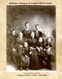
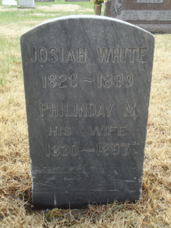
Philinday M. Munger White
| Birth | : | 3 Nov 1830 Vermont, USA |
| Death | : | 15 Jan 1897 Custer County, Nebraska, USA |
| Burial | : | Spalding Cemetery, Spalding, South Holland District, England |
| Coordinate | : | 52.7954960, -0.1519390 |
| Description | : | 1897 February 12, Friday "The Custer County Chief" Broken Bow, Nebraska, • Page 2 Mrs. Josiah White was born in Vermont Nov. 3, 1831. When three years of age her parents moved to Cayuga county, N. Y. Her parents being poor, her early life was spent in helping to make a living for a large family of brothers and sisters. She was married to Mr. Josiah White February 7, 1849, emigrated to Rockford township, Ill., in 1851, removed from there with an ox team to Osage, Mitchell county, Iowa, in 1857, where they... Read More |
frequently asked questions (FAQ):
-
Where is Philinday M. Munger White's memorial?
Philinday M. Munger White's memorial is located at: Spalding Cemetery, Spalding, South Holland District, England.
-
When did Philinday M. Munger White death?
Philinday M. Munger White death on 15 Jan 1897 in Custer County, Nebraska, USA
-
Where are the coordinates of the Philinday M. Munger White's memorial?
Latitude: 52.7954960
Longitude: -0.1519390
Family Members:
Spouse
Children

Flowers:


Nearby Cemetories:
1. Spalding Cemetery
Spalding, South Holland District, England
Coordinate: 52.7954960, -0.1519390
2. St Paul's Churchyard
Spalding, South Holland District, England
Coordinate: 52.7969559, -0.1305557
3. St. Mary's Churchyard
Pinchbeck, South Holland District, England
Coordinate: 52.8135340, -0.1589220
4. St. Laurence Churchyard
Surfleet, South Holland District, England
Coordinate: 52.8369500, -0.1436110
5. St Bartholomew's Church West Pinchbeck
Pinchbeck, South Holland District, England
Coordinate: 52.8080873, -0.2216285
6. Surfleet Cemetery
Surfleet, South Holland District, England
Coordinate: 52.8391670, -0.1383330
7. St. Mary's Cemetery
Weston, South Holland District, England
Coordinate: 52.8078662, -0.0809039
8. South Lincolnshire Crematorium
Surfleet, South Holland District, England
Coordinate: 52.8451100, -0.1475110
9. All Saints Churchyard
Moulton, South Holland District, England
Coordinate: 52.7990056, -0.0629691
10. Moulton Cemetery
Moulton, South Holland District, England
Coordinate: 52.8017000, -0.0632400
11. St Gilbert and St Hugh Churchyard
Gosberton Clough, South Holland District, England
Coordinate: 52.8518081, -0.2166268
12. St. Mary's Churchyard
Whaplode, South Holland District, England
Coordinate: 52.7974840, -0.0385520
13. Gosberton Baptist Church
Gosberton, South Holland District, England
Coordinate: 52.8651820, -0.1533940
14. Gosberton Cemetery
Gosberton, South Holland District, England
Coordinate: 52.8659400, -0.1623000
15. St. Peter and St. Paul Churchyard
Gosberton, South Holland District, England
Coordinate: 52.8690870, -0.1629740
16. Whaplode Cemetery
Whaplode, South Holland District, England
Coordinate: 52.8016190, -0.0281347
17. St. Margaret's Churchyard
Quadring, South Holland District, England
Coordinate: 52.8903400, -0.1819700
18. All Saints Churchyard
Holbeach, South Holland District, England
Coordinate: 52.8036140, 0.0142530
19. Holbeach Cemetery
Holbeach, South Holland District, England
Coordinate: 52.8062100, 0.0171500
20. St. John's Churchyard
Holbeach, South Holland District, England
Coordinate: 52.7457510, -0.0024000
21. All Saints Churchyard
Fosdyke, Boston Borough, England
Coordinate: 52.8811100, -0.0469440
22. Fosdyke Village Cemetery
Fosdyke, Boston Borough, England
Coordinate: 52.8808330, -0.0447220
23. Sutterton Village Cemetery
Sutterton, Boston Borough, England
Coordinate: 52.8994440, -0.0900000
24. St. John the Baptist Churchyard
Whaplode Drove, South Holland District, England
Coordinate: 52.7034435, -0.0476688