
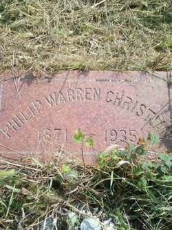

Philip Warren Christian
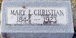
| Birth | : | 31 Aug 1871 Ohio, USA |
| Death | : | 24 Feb 1935 Davenport, Scott County, Iowa, USA |
| Burial | : | Street Cemetery, Street, Mendip District, England |
| Coordinate | : | 51.1302840, -2.7508240 |
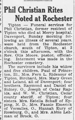
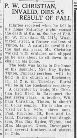
| Description | : | Obituary contributed by Find A Grave member: 4703778628 Jacie Thomsen February 1935 - The Tipton Advertiser P. W. Christian, 221 1/2 Washington street, Davenport, a former Tipton resident, died at 6:00 a.m. Sunday at the Mercy hospital as a result of injuries received in a fall Saturday night at his home. Mr. Christian had been a paralytic invalid the past six years. He walked with crutches, and Saturday about 5:00 p.m. slipped as he was about to sit down in his chair. He was 65 years of age. The body was taken to the home of his daughter, Mrs. Ray Ridenour of Tipton. Funeral services were held Tuesday at... Read More |
frequently asked questions (FAQ):
-
Where is Philip Warren Christian's memorial?
Philip Warren Christian's memorial is located at: Street Cemetery, Street, Mendip District, England.
-
When did Philip Warren Christian death?
Philip Warren Christian death on 24 Feb 1935 in Davenport, Scott County, Iowa, USA
-
Where are the coordinates of the Philip Warren Christian's memorial?
Latitude: 51.1302840
Longitude: -2.7508240
Family Members:
Parent
Spouse
Siblings

Children

Flowers:


Nearby Cemetories:
1. Religious Society of Friends Quaker Cemetery
Street, Mendip District, England
Coordinate: 51.1294100, -2.7375630
2. Holy Trinity Churchyard
Street, Mendip District, England
Coordinate: 51.1310100, -2.7330800
3. Holy Trinity Churchyard Extension
Walton, Mendip District, England
Coordinate: 51.1234150, -2.7695832
4. Holy Trinity Churchyard
Walton, Mendip District, England
Coordinate: 51.1236200, -2.7709580
5. St Benedict Churchyard
Glastonbury, Mendip District, England
Coordinate: 51.1465970, -2.7196900
6. Glastonbury Abbey
Glastonbury, Mendip District, England
Coordinate: 51.1464996, -2.7151000
7. Saint John the Baptist Churchyard
Glastonbury, Mendip District, England
Coordinate: 51.1481520, -2.7161400
8. All Saint's Churchyard
Ashcott, Sedgemoor District, England
Coordinate: 51.1309220, -2.8058870
9. Glastonbury Cemetery
Glastonbury, Mendip District, England
Coordinate: 51.1565160, -2.7132380
10. Saint Andrew Churchyard
Compton Dundon, South Somerset District, England
Coordinate: 51.0897330, -2.7442800
11. St. Mary & All Saints Churchyard
Meare, Mendip District, England
Coordinate: 51.1715900, -2.7804100
12. St Leonard Churchyard
Butleigh, Mendip District, England
Coordinate: 51.1025800, -2.6868850
13. Holy Trinity Church
Godney, Mendip District, England
Coordinate: 51.1793400, -2.7377400
14. Blessed Virgin Mary Churchyard
Shapwick, Sedgemoor District, England
Coordinate: 51.1405090, -2.8336100
15. St. Michael and All Angels Churchyard
Greinton, Sedgemoor District, England
Coordinate: 51.1240140, -2.8408590
16. St. Dunstan Churchyard
Baltonsborough, Mendip District, England
Coordinate: 51.1107200, -2.6557600
17. All Saints Churchyard
Kingweston, South Somerset District, England
Coordinate: 51.0793076, -2.6791489
18. Blessed Virgin Mary Churchyard
Moorlinch, Sedgemoor District, England
Coordinate: 51.1280000, -2.8616000
19. St Nicholas Churchyard
West Pennard, Mendip District, England
Coordinate: 51.1415596, -2.6413050
20. St. Andrew's Churchyard
High Ham, South Somerset District, England
Coordinate: 51.0760320, -2.8218400
21. High Ham Cemetery
High Ham, South Somerset District, England
Coordinate: 51.0739931, -2.8216351
22. Christ Church
Coxley, Mendip District, England
Coordinate: 51.1869530, -2.6797580
23. Saint James Churchyard
West Bradley, Mendip District, England
Coordinate: 51.1293030, -2.6332386
24. St. David's Churchyard
Barton St David, South Somerset District, England
Coordinate: 51.0828220, -2.6585470