
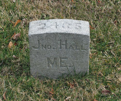
Pvt John McArthur Hall
| Birth | : | 9 Jul 1847 Waldo County, Maine, USA |
| Death | : | 17 Jan 1863 Virginia, USA |
| Burial | : | St. Peter's Churchyard, Burnley, Burnley Borough, England |
| Coordinate | : | 53.7924450, -2.2394890 |
| Plot | : | Grave 2435 |
| Description | : | Co B, 19 ME Inf. per Civil War Burials Fredericksburg Virginia, Compiled and edited by Maude E. Mercer Sellman, 1979, p. 27. Phd sent: #13812153 I believe this to be Pvt John Mcarthur Hall. b. July 9, 1847 Brooks, Waldo County Maine. Enlisted in Co B 19th Maine Infantry Regiment Aug 25, 1862 at age 18.(was actually only 15) d. Jan 19, 1863 of disease at Lacey's farm Stafford county Va. he was originnally buried there. he also had a brother in the 12th Me who survived the war. I'm trying to... Read More |
frequently asked questions (FAQ):
-
Where is Pvt John McArthur Hall's memorial?
Pvt John McArthur Hall's memorial is located at: St. Peter's Churchyard, Burnley, Burnley Borough, England.
-
When did Pvt John McArthur Hall death?
Pvt John McArthur Hall death on 17 Jan 1863 in Virginia, USA
-
Where are the coordinates of the Pvt John McArthur Hall's memorial?
Latitude: 53.7924450
Longitude: -2.2394890
Family Members:
Parent

Siblings
Flowers:


Nearby Cemetories:
1. St. Peter's Churchyard
Burnley, Burnley Borough, England
Coordinate: 53.7924450, -2.2394890
2. St. James' Churchyard
Burnley, Burnley Borough, England
Coordinate: 53.7905590, -2.2458280
3. Ebenezer Baptist Chapel Chapelyard
Burnley, Burnley Borough, England
Coordinate: 53.7975120, -2.2397260
4. Holy Trinity Churchyard
Burnley, Burnley Borough, England
Coordinate: 53.7898290, -2.2574200
5. Burnley Cemetery
Burnley, Burnley Borough, England
Coordinate: 53.7821730, -2.2795070
6. Burnley Crematorium
Burnley, Burnley Borough, England
Coordinate: 53.7821730, -2.2795070
7. St. James' Churchyard
Briercliffe, Burnley Borough, England
Coordinate: 53.8107700, -2.2031800
8. St. John the Evangelist Churchyard
Worsthorne, Burnley Borough, England
Coordinate: 53.7877640, -2.1887420
9. All Saints Churchyard
Habergham Eaves, Burnley Borough, England
Coordinate: 53.7971060, -2.2913770
10. Marsden Friends Burial Ground
Marsden, Metropolitan Borough of Kirklees, England
Coordinate: 53.8241910, -2.2197410
11. Haggate Baptist Church Burial Ground
Burnley Borough, England
Coordinate: 53.8145048, -2.1960725
12. Hill Lane Baptist Church Churchyard
Briercliffe, Burnley Borough, England
Coordinate: 53.8161467, -2.1875368
13. St. Paul's Churchyard
Nelson, Pendle Borough, England
Coordinate: 53.8289250, -2.2157520
14. St. Anne Churchyard
Fence, Pendle Borough, England
Coordinate: 53.8304372, -2.2679552
15. Wheatley Lane Methodist Churchyard
Fence, Pendle Borough, England
Coordinate: 53.8341457, -2.2596202
16. St John Churchyard
Higham, Pendle Borough, England
Coordinate: 53.8251420, -2.2898120
17. St. John's Cemetery
Padiham, Burnley Borough, England
Coordinate: 53.7948720, -2.3145290
18. St. Leonard's Churchyard
Padiham, Burnley Borough, England
Coordinate: 53.8022600, -2.3164300
19. St Margaret Churchyard
Hapton, Burnley Borough, England
Coordinate: 53.7802400, -2.3169230
20. Wesleyan Methodist Chapel Chapelyard
Padiham, Burnley Borough, England
Coordinate: 53.8018980, -2.3181730
21. Wheatley Lane Inghamite Church Churchyard
Wheatley Lane, Pendle Borough, England
Coordinate: 53.8412800, -2.2457100
22. St. John the Divine Churchyard
Cliviger, Burnley Borough, England
Coordinate: 53.7533610, -2.1895090
23. St Leonard Churchyard Extension
Padiham, Burnley Borough, England
Coordinate: 53.7991800, -2.3222000
24. John Ecroyd's Orchard
Lancaster, City of Lancaster, England
Coordinate: 53.8201990, -2.1697920