
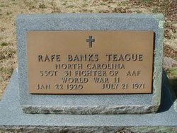
Rafe Banks Teague
| Birth | : | 22 Jan 1920 Waynesville, Haywood County, North Carolina, USA |
| Death | : | 21 Jul 1971 Franklin, Macon County, North Carolina, USA |
| Burial | : | Pierson Township Cemetery, Pierson, Montcalm County, USA |
| Coordinate | : | 43.3381004, -85.5006027 |
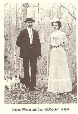
| Description | : | The Franklin Press - 29 July 1971 Rafe Teague Rafe Banks Teague, died last died last Tuesday in Angel Community Hospital following an illness of three months. He was 51 years of age. The son of the late Charles W and Gertrude Cumi McCracken Teague, he was a native of Macon County. He served as superintendent of transportation for the public schools of Macon County for a number of years prior to his illness. He was a veteran of WW II. Funeral services were conducted at the First United Methodist Church... Read More |
frequently asked questions (FAQ):
-
Where is Rafe Banks Teague's memorial?
Rafe Banks Teague's memorial is located at: Pierson Township Cemetery, Pierson, Montcalm County, USA.
-
When did Rafe Banks Teague death?
Rafe Banks Teague death on 21 Jul 1971 in Franklin, Macon County, North Carolina, USA
-
Where are the coordinates of the Rafe Banks Teague's memorial?
Latitude: 43.3381004
Longitude: -85.5006027
Family Members:
Parent
Spouse
Siblings


Nearby Cemetories:
1. Pierson Township Cemetery
Pierson, Montcalm County, USA
Coordinate: 43.3381004, -85.5006027
2. Sand Lake Cemetery
Sand Lake, Kent County, USA
Coordinate: 43.2861480, -85.5313380
3. Saint Mary's Cemetery
Sand Lake, Kent County, USA
Coordinate: 43.2717018, -85.4969025
4. North Ensley Cemetery
Ensley Center, Newaygo County, USA
Coordinate: 43.3671989, -85.5935974
5. Reynolds Township Cemetery
Howard City, Montcalm County, USA
Coordinate: 43.4101300, -85.4767100
6. Coral Cemetery
Coral, Montcalm County, USA
Coordinate: 43.3671989, -85.4060974
7. Saint Johns Catholic Cemetery
Ensley Center, Newaygo County, USA
Coordinate: 43.3664017, -85.5969009
8. Crandall Cemetery
Ensley Center, Newaygo County, USA
Coordinate: 43.2938995, -85.5939026
9. Coady Cemetery
Maple Valley Township, Montcalm County, USA
Coordinate: 43.3540520, -85.3825890
10. Maple Valley Cemetery
Maple Valley Township, Montcalm County, USA
Coordinate: 43.3358002, -85.3724976
11. Punches Cemetery
Cedar Springs, Kent County, USA
Coordinate: 43.2467003, -85.5317001
12. Bouton Family Farm Burial Site
Reynolds Township, Montcalm County, USA
Coordinate: 43.4294960, -85.5555570
13. Trufant Cemetery
Maple Valley Township, Montcalm County, USA
Coordinate: 43.3083000, -85.3653030
14. Christian Plains Cemetery
Croton Township, Newaygo County, USA
Coordinate: 43.4100200, -85.6028200
15. East Nelson Cemetery
Cedar Springs, Kent County, USA
Coordinate: 43.2355995, -85.4561005
16. Amble Cemetery
Amble, Montcalm County, USA
Coordinate: 43.4352989, -85.4024963
17. Oak Grove Cemetery
Croton Township, Newaygo County, USA
Coordinate: 43.4061012, -85.6430969
18. Solon Township Cemetery
Cedar Springs, Kent County, USA
Coordinate: 43.2344589, -85.6100235
19. Elmwood Cemetery
Cedar Springs, Kent County, USA
Coordinate: 43.2118988, -85.5532990
20. West Pine Cemetery
Coral, Montcalm County, USA
Coordinate: 43.3669014, -85.3227997
21. Stearns Prairie Cemetery
Croton Township, Newaygo County, USA
Coordinate: 43.4543991, -85.5980988
22. Culp Cemetery
Croton Township, Newaygo County, USA
Coordinate: 43.4537900, -85.6078400
23. DeGraw Family Cemetery
Cedar Springs, Kent County, USA
Coordinate: 43.2066585, -85.4283281
24. Saint Margarets Catholic Cemetery
Spencer Township, Kent County, USA
Coordinate: 43.2063890, -85.4169440