
| Birth | : | 20 Jan 1920 Quick, Pottawattamie County, Iowa, USA |
| Death | : | 14 Jun 2014 Council Bluffs, Pottawattamie County, Iowa, USA |
| Burial | : | Hardin Township Cemetery, McClelland, Pottawattamie County, USA |
| Coordinate | : | 41.2949982, -95.6513977 |
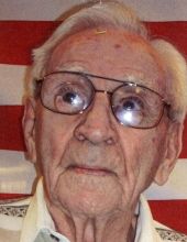
| Description | : | Ralph Edgar Morse was the son of Edgar A. & Emma H. Morse. Ralph was the third of five children, and the oldest son. He was drafted into the Army during WWII and served four years as a messenger with the 3rd Armored Division. He met his wife, Arlene Susan Peters, while training at Indiantown Gap in Pennsylvania. She corresponded with him during the war and were they married Wednesday, March 19, 1946. Ralph was known for his hard work and honesty. He taught his children and grandchildren that a good name meant being a person of integrity.... Read More |
frequently asked questions (FAQ):
-
Where is Ralph Edgar Morse's memorial?
Ralph Edgar Morse's memorial is located at: Hardin Township Cemetery, McClelland, Pottawattamie County, USA.
-
When did Ralph Edgar Morse death?
Ralph Edgar Morse death on 14 Jun 2014 in Council Bluffs, Pottawattamie County, Iowa, USA
-
Where are the coordinates of the Ralph Edgar Morse's memorial?
Latitude: 41.2949982
Longitude: -95.6513977
Family Members:
Parent

Spouse
Siblings
Flowers:


Nearby Cemetories:
1. Hardin Township Cemetery
McClelland, Pottawattamie County, USA
Coordinate: 41.2949982, -95.6513977
2. Pottawattamie County Home Cemetery
McClelland, Pottawattamie County, USA
Coordinate: 41.3269400, -95.6691738
3. Saint Paul Lutheran Cemetery
Treynor, Pottawattamie County, USA
Coordinate: 41.2322000, -95.6380000
4. Downsville Cemetery
Pottawattamie County, USA
Coordinate: 41.3502998, -95.7039032
5. Zion Congregational Cemetery
Treynor, Pottawattamie County, USA
Coordinate: 41.2325090, -95.6079200
6. Fairview Pioneer Cemetery
Treynor, Pottawattamie County, USA
Coordinate: 41.2812843, -95.5555267
7. Saint Columbanus Cemetery
Weston, Pottawattamie County, USA
Coordinate: 41.3429440, -95.7435260
8. H G Fisher Cemetery
Underwood, Pottawattamie County, USA
Coordinate: 41.3838997, -95.6889038
9. Jones - Williams Cemetery
Pottawattamie County, USA
Coordinate: 41.3761000, -95.5846000
10. Stoker-Graybill Cemetery
Council Bluffs, Pottawattamie County, USA
Coordinate: 41.2532620, -95.7751770
11. Keg Creek Township Cemetery
Treynor, Pottawattamie County, USA
Coordinate: 41.1913986, -95.6893997
12. Garner Cemetery
Council Bluffs, Pottawattamie County, USA
Coordinate: 41.2956161, -95.8001709
13. Gregg Cemetery
Weston, Pottawattamie County, USA
Coordinate: 41.3330000, -95.7931000
14. Hazel Dell Cemetery
Council Bluffs, Pottawattamie County, USA
Coordinate: 41.3489723, -95.7939911
15. Castor Cemetery
Underwood, Pottawattamie County, USA
Coordinate: 41.4127040, -95.6887490
16. Cedar Lawn Cemetery
Council Bluffs, Pottawattamie County, USA
Coordinate: 41.2694016, -95.8182983
17. Saint Joseph Cemetery
Council Bluffs, Pottawattamie County, USA
Coordinate: 41.2722015, -95.8208008
18. Green Valley Cemetery
Council Bluffs, Pottawattamie County, USA
Coordinate: 41.2743988, -95.8225021
19. Zion Cemetery
Pottawattamie County, USA
Coordinate: 41.1778000, -95.7272000
20. Oak Hill Cemetery
Council Bluffs, Pottawattamie County, USA
Coordinate: 41.2700900, -95.8226400
21. Bikhor Cholim Cemetery
Council Bluffs, Pottawattamie County, USA
Coordinate: 41.2703670, -95.8229350
22. Walnut Hill Cemetery
Council Bluffs, Pottawattamie County, USA
Coordinate: 41.2719002, -95.8255997
23. Clark Cemetery
Pottawattamie County, USA
Coordinate: 41.2551610, -95.8223390
24. Ridgewood Cemetery
Council Bluffs, Pottawattamie County, USA
Coordinate: 41.2694016, -95.8272018