
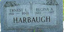
Regina A. Boland Harbaugh
| Birth | : | 16 Feb 1923 Elkader, Clayton County, Iowa, USA |
| Death | : | 31 Mar 1987 Manchester, Delaware County, Iowa, USA |
| Burial | : | Boistfort Cemetery, Boistfort, Lewis County, USA |
| Coordinate | : | 46.5228700, -123.1313650 |
| Description | : | Regina A. Boland married September 23, 1943, at St. Joseph's Catholic Church in Elkader: Ernest L. HARBAUGH. |
frequently asked questions (FAQ):
-
Where is Regina A. Boland Harbaugh's memorial?
Regina A. Boland Harbaugh's memorial is located at: Boistfort Cemetery, Boistfort, Lewis County, USA.
-
When did Regina A. Boland Harbaugh death?
Regina A. Boland Harbaugh death on 31 Mar 1987 in Manchester, Delaware County, Iowa, USA
-
Where are the coordinates of the Regina A. Boland Harbaugh's memorial?
Latitude: 46.5228700
Longitude: -123.1313650
Family Members:
Parent

Spouse

Siblings

Flowers:


Nearby Cemetories:
1. Boistfort Cemetery
Boistfort, Lewis County, USA
Coordinate: 46.5228700, -123.1313650
2. Original Boistfort Cemetery
Boistfort, Lewis County, USA
Coordinate: 46.5234680, -123.1287680
3. Pleasant Hill Cemetery
Bunker, Lewis County, USA
Coordinate: 46.6088840, -123.0863790
4. Snow Cemetery
Lewis County, USA
Coordinate: 46.4552994, -123.0083008
5. Forest Lawn Cemetery
Pe Ell, Lewis County, USA
Coordinate: 46.5649190, -123.3008280
6. Saint Josephs Catholic Cemetery
Pe Ell, Lewis County, USA
Coordinate: 46.5648880, -123.3031070
7. Saint Joseph Cemetery
Pe Ell, Lewis County, USA
Coordinate: 46.5732590, -123.3012070
8. Winlock Cemetery
Winlock, Lewis County, USA
Coordinate: 46.4898000, -122.9336000
9. Claquato Cemetery
Chehalis, Lewis County, USA
Coordinate: 46.6469002, -123.0216980
10. Little Falls Cemetery
Vader, Lewis County, USA
Coordinate: 46.4105988, -122.9867020
11. Newaukum Hill Cemetery
Lewis County, USA
Coordinate: 46.6338980, -122.9768320
12. Dryad Cemetery
Dryad, Lewis County, USA
Coordinate: 46.6467667, -123.2665329
13. Vader Catholic Cemetery
Vader, Lewis County, USA
Coordinate: 46.4051000, -122.9697000
14. Napavine Cemetery
Napavine, Lewis County, USA
Coordinate: 46.5817000, -122.9039000
15. Saint Urban Catholic Cemetery
Winlock, Lewis County, USA
Coordinate: 46.5177200, -122.8856500
16. Fern Hill Cemetery
Chehalis, Lewis County, USA
Coordinate: 46.6366710, -122.9418560
17. Greenwood Cemetery
Chehalis, Lewis County, USA
Coordinate: 46.6511002, -122.9389038
18. Toledo Cemetery
Toledo, Lewis County, USA
Coordinate: 46.4425400, -122.8500500
19. Saint Francis Xavier Cemetery
Toledo, Lewis County, USA
Coordinate: 46.4670300, -122.8229400
20. Pioneer Cemetery
Centralia, Lewis County, USA
Coordinate: 46.7290300, -122.9898100
21. Mountain View Cemetery
Centralia, Lewis County, USA
Coordinate: 46.7289009, -122.9843979
22. Washington Lawn Cemetery
Centralia, Lewis County, USA
Coordinate: 46.7209320, -122.9606040
23. Finn Hill Cemetery
Lewis County, USA
Coordinate: 46.7564011, -123.1919022
24. Greenwood Memorial Park
Centralia, Lewis County, USA
Coordinate: 46.7372017, -122.9824982