
| Birth | : | 14 Dec 1869 Alcorn County, Mississippi, USA |
| Death | : | 25 Apr 1920 Sugar Tree, Decatur County, Tennessee, USA |
| Burial | : | Zion United Church of Christ Cemetery, Gladstone, Jefferson County, USA |
| Coordinate | : | 40.1630000, -97.2910000 |
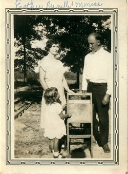
| Description | : | Erastus was a Baptist Preacher as was his father and many uncles and 2 sons. He and Lucy Newsom had 9 children. |
frequently asked questions (FAQ):
-
Where is Rev Erastus Marion Franks's memorial?
Rev Erastus Marion Franks's memorial is located at: Zion United Church of Christ Cemetery, Gladstone, Jefferson County, USA.
-
When did Rev Erastus Marion Franks death?
Rev Erastus Marion Franks death on 25 Apr 1920 in Sugar Tree, Decatur County, Tennessee, USA
-
Where are the coordinates of the Rev Erastus Marion Franks's memorial?
Latitude: 40.1630000
Longitude: -97.2910000
Family Members:
Parent

Spouse
Siblings
Children
Flowers:


Nearby Cemetories:
1. Zion United Church of Christ Cemetery
Gladstone, Jefferson County, USA
Coordinate: 40.1630000, -97.2910000
2. Pleasant Hill Cemetery
Jefferson County, USA
Coordinate: 40.1595910, -97.2573280
3. Moles Cemetery
Powell, Jefferson County, USA
Coordinate: 40.2015100, -97.2647950
4. Grace Lutheran Cemetery
Gladstone, Jefferson County, USA
Coordinate: 40.1620670, -97.3522350
5. Powell Cemetery
Powell, Jefferson County, USA
Coordinate: 40.2332993, -97.2742004
6. Helvey Cemetery
Helvey, Jefferson County, USA
Coordinate: 40.2347354, -97.2533342
7. Meridian Presbyterian Cemetery
Meridian Township, Jefferson County, USA
Coordinate: 40.2178001, -97.3625031
8. Hunt Family Plot
Reynolds, Jefferson County, USA
Coordinate: 40.0868380, -97.3115940
9. George Winslow Gravesite
Fairbury, Jefferson County, USA
Coordinate: 40.2074800, -97.2061580
10. Union Cemetery
Gilead, Thayer County, USA
Coordinate: 40.1319008, -97.4047012
11. Woltemath Lone Grave
Alexandria, Thayer County, USA
Coordinate: 40.2343600, -97.3691800
12. Catholic Cemetery
Alexandria, Thayer County, USA
Coordinate: 40.2202988, -97.3878021
13. Richland Center Cemetery
Jefferson County, USA
Coordinate: 40.2186012, -97.1900024
14. Mount Gilead Cemetery
Gilead, Thayer County, USA
Coordinate: 40.1906000, -97.4246500
15. Fairbury Cemetery
Fairbury, Jefferson County, USA
Coordinate: 40.1314011, -97.1557999
16. Rose Creek Cemetery
Rose Creek Township, Thayer County, USA
Coordinate: 40.0705986, -97.3694000
17. Huber Cemetery
Reynolds, Jefferson County, USA
Coordinate: 40.0493000, -97.3085000
18. Kennedy Lone Grave
Gilead, Thayer County, USA
Coordinate: 40.1715900, -97.4425500
19. Silver Creek Cemetery
Jefferson County, USA
Coordinate: 40.0522003, -97.2367020
20. Alexandria Cemetery
Alexandria, Thayer County, USA
Coordinate: 40.2489014, -97.4060974
21. Grandy Cemetery
Jansen, Jefferson County, USA
Coordinate: 40.1897011, -97.1324997
22. Saint Paul's Lutheran Church Cemetery
Gilead, Thayer County, USA
Coordinate: 40.1108000, -97.4449000
23. Bartel Cemetery
Jansen, Jefferson County, USA
Coordinate: 40.1903000, -97.1141968
24. Bower Cemetery
Jefferson County, USA
Coordinate: 40.2621994, -97.1517029