
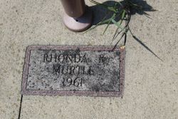
Rhonda Kay Murtle
| Birth | : | 26 Oct 1961 Perry, Dallas County, Iowa, USA |
| Death | : | 2 Nov 1961 Des Moines, Polk County, Iowa, USA |
| Burial | : | Claquato Cemetery, Chehalis, Lewis County, USA |
| Coordinate | : | 46.6469002, -123.0216980 |
| Description | : | Daughter of Rodney Lee Murtle and Cleta Marie Davis Murtle |
frequently asked questions (FAQ):
-
Where is Rhonda Kay Murtle's memorial?
Rhonda Kay Murtle's memorial is located at: Claquato Cemetery, Chehalis, Lewis County, USA.
-
When did Rhonda Kay Murtle death?
Rhonda Kay Murtle death on 2 Nov 1961 in Des Moines, Polk County, Iowa, USA
-
Where are the coordinates of the Rhonda Kay Murtle's memorial?
Latitude: 46.6469002
Longitude: -123.0216980
Family Members:
Parent

Flowers:


Nearby Cemetories:
1. Claquato Cemetery
Chehalis, Lewis County, USA
Coordinate: 46.6469002, -123.0216980
2. Newaukum Hill Cemetery
Lewis County, USA
Coordinate: 46.6338980, -122.9768320
3. Fern Hill Cemetery
Chehalis, Lewis County, USA
Coordinate: 46.6366710, -122.9418560
4. Greenwood Cemetery
Chehalis, Lewis County, USA
Coordinate: 46.6511002, -122.9389038
5. Pleasant Hill Cemetery
Bunker, Lewis County, USA
Coordinate: 46.6088840, -123.0863790
6. Pioneer Cemetery
Centralia, Lewis County, USA
Coordinate: 46.7290300, -122.9898100
7. Washington Lawn Cemetery
Centralia, Lewis County, USA
Coordinate: 46.7209320, -122.9606040
8. Mountain View Cemetery
Centralia, Lewis County, USA
Coordinate: 46.7289009, -122.9843979
9. Greenwood Memorial Park
Centralia, Lewis County, USA
Coordinate: 46.7372017, -122.9824982
10. Napavine Cemetery
Napavine, Lewis County, USA
Coordinate: 46.5817000, -122.9039000
11. Lincoln Creek Cemetery
Galvin, Lewis County, USA
Coordinate: 46.7604700, -123.1446600
12. Original Boistfort Cemetery
Boistfort, Lewis County, USA
Coordinate: 46.5234680, -123.1287680
13. Boistfort Cemetery
Boistfort, Lewis County, USA
Coordinate: 46.5228700, -123.1313650
14. Cogdil Family Cemetery
Thurston County, USA
Coordinate: 46.7747010, -122.8826590
15. Saint Urban Catholic Cemetery
Winlock, Lewis County, USA
Coordinate: 46.5177200, -122.8856500
16. Finn Hill Cemetery
Lewis County, USA
Coordinate: 46.7564011, -123.1919022
17. Dryad Cemetery
Dryad, Lewis County, USA
Coordinate: 46.6467667, -123.2665329
18. Winlock Cemetery
Winlock, Lewis County, USA
Coordinate: 46.4898000, -122.9336000
19. Grand Mound Cemetery
Rochester, Thurston County, USA
Coordinate: 46.8213997, -123.0199966
20. Secena Cemetery
Oakville, Grays Harbor County, USA
Coordinate: 46.8061600, -123.1611900
21. Chehalis Tribal Cemetery
Thurston County, USA
Coordinate: 46.8068570, -123.1602260
22. Deskins Family Cemetery
Chehalis, Lewis County, USA
Coordinate: 46.6878000, -122.7530000
23. Snow Cemetery
Lewis County, USA
Coordinate: 46.4552994, -123.0083008
24. Saint Joseph Cemetery
Pe Ell, Lewis County, USA
Coordinate: 46.5732590, -123.3012070