
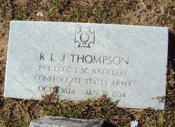
Richard L. Jesse Thompson
| Birth | : | 8 Oct 1824 Orangeburg County, South Carolina, USA |
| Death | : | 29 Jan 1884 Orangeburg County, South Carolina, USA |
| Burial | : | St. Mary's Churchyard, Westow, Ryedale District, England |
| Coordinate | : | 54.0846190, -0.8406850 |
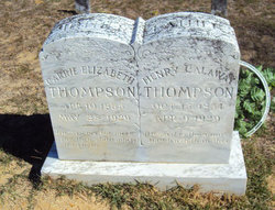
| Description | : | His grave was dedicated by the Daughters of the Confederacy and the Sons of the Confederacy on May 18, 2003. |
frequently asked questions (FAQ):
-
Where is Richard L. Jesse Thompson's memorial?
Richard L. Jesse Thompson's memorial is located at: St. Mary's Churchyard, Westow, Ryedale District, England.
-
When did Richard L. Jesse Thompson death?
Richard L. Jesse Thompson death on 29 Jan 1884 in Orangeburg County, South Carolina, USA
-
Where are the coordinates of the Richard L. Jesse Thompson's memorial?
Latitude: 54.0846190
Longitude: -0.8406850
Family Members:
Parent
Spouse
Siblings
Children
Flowers:


Nearby Cemetories:
1. St. Mary's Churchyard
Westow, Ryedale District, England
Coordinate: 54.0846190, -0.8406850
2. Kirkham Priory
Kirkham, Ryedale District, England
Coordinate: 54.0826180, -0.8768470
3. St. Margaret's Churchyard
Huttons Ambo, Ryedale District, England
Coordinate: 54.1066490, -0.8490640
4. St Michael Churchyard
Crambe, Ryedale District, England
Coordinate: 54.0744550, -0.8809390
5. Burythorpe Churchyard
Burythorpe, Ryedale District, England
Coordinate: 54.0752951, -0.7955984
6. St Andrew Churchyard
Langton, Ryedale District, England
Coordinate: 54.0934510, -0.7834680
7. Howsham Churchyard
Howsham, Ryedale District, England
Coordinate: 54.0565520, -0.8755670
8. St John the Evangelist Churchyard
Welburn (Malton), Ryedale District, England
Coordinate: 54.1008850, -0.8985440
9. Castle Howard Mausoleum
Castle Howard, Ryedale District, England
Coordinate: 54.1173870, -0.8886900
10. St John the Baptist
Acklam, Ryedale District, England
Coordinate: 54.0451010, -0.8006330
11. St Mary Churchyard
Birdsall, Ryedale District, England
Coordinate: 54.0780000, -0.7508000
12. St Peter Churchyard
Norton, Ryedale District, England
Coordinate: 54.1289040, -0.7861910
13. All Saints Churchyard
Foston, Ryedale District, England
Coordinate: 54.0775719, -0.9331510
14. St Martin Churchyard
Bulmer, Ryedale District, England
Coordinate: 54.0997510, -0.9317700
15. St Peter and St Paul Churchyard
Scrayingham, Ryedale District, England
Coordinate: 54.0342510, -0.8826130
16. Norton Cemetery
Norton, Ryedale District, England
Coordinate: 54.1306400, -0.7834200
17. St. Leonard with St. Mary Churchyard
Malton, Ryedale District, England
Coordinate: 54.1348110, -0.7946110
18. Coneysthorpe Cemetery
Coneysthorpe, Ryedale District, England
Coordinate: 54.1308750, -0.9042820
19. Malton Cemetery
Malton, Ryedale District, England
Coordinate: 54.1392670, -0.7980300
20. St Botolph Churchyard
Bossall, Ryedale District, England
Coordinate: 54.0375570, -0.9047540
21. St Helen Churchyard
Amotherby, Ryedale District, England
Coordinate: 54.1512000, -0.8521000
22. St Mary the Virgin Priory Churchyard
Malton, Ryedale District, England
Coordinate: 54.1427520, -0.7786450
23. Old Malton Cemetery
Malton, Ryedale District, England
Coordinate: 54.1443200, -0.7808900
24. All Saints Churchyard
Appleton-le-Street, Ryedale District, England
Coordinate: 54.1529500, -0.8766300