

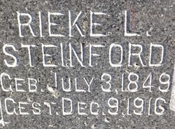
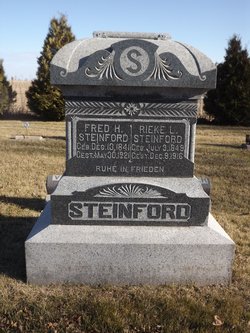
Rieke Lena Rieberg Steinford
| Birth | : | 3 Jul 1849 Germany |
| Death | : | 9 Dec 1916 Keystone, Benton County, Iowa, USA |
| Burial | : | Lothrop Cemetery, Bishopton, Estrie Region, Canada |
| Coordinate | : | 45.5843170, -71.6009770 |
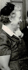
| Description | : | At an early hour last Sat morning occurred the death of Mrs Fritz Steinford at her home in Keystone after a short illness. A paralytic stroke a few hours before her death resulted fatally. Rieke Lena Rieberg was born July 13 1849 at Strahlsend, Germany, and died Dec.9,1916, aged 67 years, 5 months and 3 days. On Apr. 26,1869 at her home in Germany,she was united in marriage to Fritz Herman Steinford and to this union were born 11 children, all but 1 of whom, Emma Ebel,survive the mother. They are Mrs. Peter Kruse, Peterson, Iowa; Mrs. Claus Koep, Spencer,Iowa; Mrs... Read More |
frequently asked questions (FAQ):
-
Where is Rieke Lena Rieberg Steinford's memorial?
Rieke Lena Rieberg Steinford's memorial is located at: Lothrop Cemetery, Bishopton, Estrie Region, Canada.
-
When did Rieke Lena Rieberg Steinford death?
Rieke Lena Rieberg Steinford death on 9 Dec 1916 in Keystone, Benton County, Iowa, USA
-
Where are the coordinates of the Rieke Lena Rieberg Steinford's memorial?
Latitude: 45.5843170
Longitude: -71.6009770
Family Members:
Spouse
Children
Flowers:


Nearby Cemetories:
1. Lothrop Cemetery
Bishopton, Estrie Region, Canada
Coordinate: 45.5843170, -71.6009770
2. Dudswell Center Cemetery
Bishopton, Estrie Region, Canada
Coordinate: 45.5845160, -71.6012720
3. Cimetière Saint-Clément Bishopton
Dudswell, Estrie Region, Canada
Coordinate: 45.5850500, -71.5995400
4. Lakeside Cemetery
Dudswell, Estrie Region, Canada
Coordinate: 45.5868000, -71.5955000
5. Marbleton Methodist Cemetery
Marbleton, Estrie Region, Canada
Coordinate: 45.6277600, -71.5838500
6. Saint Paul Anglican Cemetery
Marbleton, Estrie Region, Canada
Coordinate: 45.6279800, -71.5830200
7. Cimetière Saint-Adolphe
Dudswell, Estrie Region, Canada
Coordinate: 45.6402330, -71.5855970
8. Grace United Cemetery
Brookbury, Estrie Region, Canada
Coordinate: 45.5397500, -71.5393100
9. Saint John Cemetery
Brookbury, Estrie Region, Canada
Coordinate: 45.5092400, -71.5454850
10. Cimetière Saint-Louis
East Angus, Estrie Region, Canada
Coordinate: 45.5046560, -71.6596360
11. Cimetière Saint-Camille
Saint-Camille, Estrie Region, Canada
Coordinate: 45.6773400, -71.6925800
12. Cimetière Saint-Raphaël
Bury, Estrie Region, Canada
Coordinate: 45.4731590, -71.5071190
13. Bury Cemetery
Bury, Estrie Region, Canada
Coordinate: 45.4697100, -71.4971300
14. Thompson Burial Ground Memorial
Ham-Sud, Estrie Region, Canada
Coordinate: 45.7285000, -71.5951640
15. Lingwick Protestant Cemetery
Gould, Estrie Region, Canada
Coordinate: 45.5939200, -71.3728100
16. Cimetière Saint-Camille
Cookshire-Eaton, Estrie Region, Canada
Coordinate: 45.4221800, -71.6088700
17. Cookshire Community Cemetery
Cookshire-Eaton, Estrie Region, Canada
Coordinate: 45.4213300, -71.6090700
18. St-Thomas Bown Anglican Cemetery
Bury, Estrie Region, Canada
Coordinate: 45.4802800, -71.4184700
19. Cimetière Saint-Stanislas
Ascot Corner, Estrie Region, Canada
Coordinate: 45.4507430, -71.7529310
20. Cimetière Saint-Joseph
Ham-Sud, Estrie Region, Canada
Coordinate: 45.7573120, -71.5994590
21. Ascot Corner Pioneer Cemetery
Ascot Corner, Estrie Region, Canada
Coordinate: 45.4487080, -71.7588140
22. Cimetière Saint-Jacques le Mineur
Cookshire-Eaton, Estrie Region, Canada
Coordinate: 45.3912260, -71.4778960
23. Island Brook Cemetery
Cookshire-Eaton, Estrie Region, Canada
Coordinate: 45.3881000, -71.4744800
24. Eaton Cemetery
Eaton, Estrie Region, Canada
Coordinate: 45.3672100, -71.6251500