
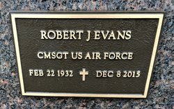
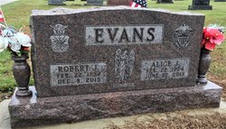
Robert Josef “Bob or Robert Joe” Evans
| Birth | : | 22 Feb 1932 Oklahoma County, Oklahoma, USA |
| Death | : | 8 Dec 2015 Erie County, Ohio, USA |
| Burial | : | Farmer Cemetery, Farmer, Defiance County, USA |
| Coordinate | : | 41.3903008, -84.6410980 |
| Description | : | Robert J. Evans, age 83, of Bryan, Ohio, died at 3:10 A.M. on Tuesday, December 8, 2015, at the Ohio Veteran’s Home in Sandusky, Ohio, where he had been a resident. Mr. Evans retired from the United States Air Force as a Chief Master Sargent with over 20 years of service. He was a Management Engineer and Computer Specialist with the Air Force. He was a Life Member of the Bryan VFW Post #2489. Robert J. Evans, was born on February 22, 1932, in Oklahoma City, Oklahoma, the son of John V. and Opal F. (Mainard) Evans. He married Alice J.... Read More |
frequently asked questions (FAQ):
-
Where is Robert Josef “Bob or Robert Joe” Evans's memorial?
Robert Josef “Bob or Robert Joe” Evans's memorial is located at: Farmer Cemetery, Farmer, Defiance County, USA.
-
When did Robert Josef “Bob or Robert Joe” Evans death?
Robert Josef “Bob or Robert Joe” Evans death on 8 Dec 2015 in Erie County, Ohio, USA
-
Where are the coordinates of the Robert Josef “Bob or Robert Joe” Evans's memorial?
Latitude: 41.3903008
Longitude: -84.6410980
Family Members:
Flowers:


Nearby Cemetories:
1. Farmer Cemetery
Farmer, Defiance County, USA
Coordinate: 41.3903008, -84.6410980
2. Upper Lost Creek Cemetery
Farmer, Defiance County, USA
Coordinate: 41.3840000, -84.6700000
3. Kemp Cemetery
Defiance County, USA
Coordinate: 41.3703003, -84.6802979
4. Lost Creek Cemetery
Farmer, Defiance County, USA
Coordinate: 41.3553000, -84.6700000
5. Williams Center Cemetery
Williams Center, Williams County, USA
Coordinate: 41.4288902, -84.6125031
6. Tamarack Cemetery
Milford Township, Defiance County, USA
Coordinate: 41.4117012, -84.7089005
7. Zion Lutheran Church Cemetery
Defiance County, USA
Coordinate: 41.4261017, -84.7099991
8. Fetters Cemetery
Williams County, USA
Coordinate: 41.4519500, -84.6159900
9. Melbern-Neihardt Cemetery
Melbern, Williams County, USA
Coordinate: 41.4633600, -84.6416330
10. Lintz Cemetery
Ney, Defiance County, USA
Coordinate: 41.3760986, -84.5402985
11. Trinity Lutheran Cemetery
Ney, Defiance County, USA
Coordinate: 41.4016991, -84.5353012
12. Yackee Cemetery
Williams County, USA
Coordinate: 41.4707985, -84.6324997
13. Ney Cemetery
Ney, Defiance County, USA
Coordinate: 41.3856010, -84.5271988
14. Six Corners Cemetery
Hicksville, Defiance County, USA
Coordinate: 41.3213997, -84.7153015
15. Saint Johns Lutheran Cemetery
Sherwood, Defiance County, USA
Coordinate: 41.3092003, -84.5931015
16. Doud Cemetery
Ney, Defiance County, USA
Coordinate: 41.3811680, -84.5161110
17. Fountain Grove Cemetery
Bryan, Williams County, USA
Coordinate: 41.4572182, -84.5480576
18. Thomas Cemetery
Williams County, USA
Coordinate: 41.4769100, -84.6994240
19. Brown Cemetery
Bryan, Williams County, USA
Coordinate: 41.4822006, -84.5935974
20. Maple Grove Cemetery
Edgerton, Williams County, USA
Coordinate: 41.4435997, -84.7521973
21. St. Mary's Cemetery
Edgerton, Williams County, USA
Coordinate: 41.4441120, -84.7542700
22. Clarksville Cemetery
Edgerton, Williams County, USA
Coordinate: 41.4281006, -84.7677994
23. Auglaize Village Cemetery
Defiance, Defiance County, USA
Coordinate: 41.3399760, -84.5165610
24. Funk Cemetery
Defiance County, USA
Coordinate: 41.3396988, -84.5164032