
| Birth | : | 17 Jun 1868 Illinois, USA |
| Death | : | 11 Jul 1964 Sedan, Chautauqua County, Kansas, USA |
| Burial | : | Church and Clayton-le-Moors Cemetery, Accrington, Hyndburn Borough, England |
| Coordinate | : | 53.7630200, -2.3804820 |
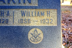
| Description | : | The following biographical sketch is added by request of Gerald Hobson: "Robert Wesley Akin, son of Joseph Wiley and Cynthia Ann Willmore Akin, was born June 17, 1868, in Benton County, Ill. At the age of five, he moved with his parents to Kansas. The family first settled at the Hart's Mill settlement east of Hewins. After living there a year, they moved to a farm on Otter Creek, northwest of Cedar Vale, where he grew to manhood. He first married Miss Daisy Vandruff and to this union two children were born. After her death, he married Miss... Read More |
frequently asked questions (FAQ):
-
Where is Robert Wesley Akin's memorial?
Robert Wesley Akin's memorial is located at: Church and Clayton-le-Moors Cemetery, Accrington, Hyndburn Borough, England.
-
When did Robert Wesley Akin death?
Robert Wesley Akin death on 11 Jul 1964 in Sedan, Chautauqua County, Kansas, USA
-
Where are the coordinates of the Robert Wesley Akin's memorial?
Latitude: 53.7630200
Longitude: -2.3804820
Family Members:
Parent

Spouse
Siblings

Children
Flowers:


Nearby Cemetories:
1. Church and Clayton-le-Moors Cemetery
Accrington, Hyndburn Borough, England
Coordinate: 53.7630200, -2.3804820
2. St James Churchyard
Church, Hyndburn Borough, England
Coordinate: 53.7574640, -2.3942660
3. All Saints Churchyard
Clayton-le-Moors, Hyndburn Borough, England
Coordinate: 53.7738520, -2.3881690
4. Barnes Square Weslyan Methodist Churchyard
Clayton-le-Moors, Hyndburn Borough, England
Coordinate: 53.7744350, -2.3853800
5. St. James' Parish Church
Accrington, Hyndburn Borough, England
Coordinate: 53.7519900, -2.3652600
6. St Marys Burial Ground
Clayton-le-Moors, Hyndburn Borough, England
Coordinate: 53.7792778, -2.3705871
7. Accrington Cemetery and Crematorium
Accrington, Hyndburn Borough, England
Coordinate: 53.7623787, -2.3508649
8. Christ Church Churchyard
Accrington, Hyndburn Borough, England
Coordinate: 53.7478560, -2.3605820
9. Great Harwood Cemetery
Great Harwood, Hyndburn Borough, England
Coordinate: 53.7796190, -2.4091680
10. Our Lady and Saint Hubert
Great Harwood, Hyndburn Borough, England
Coordinate: 53.7851070, -2.4009760
11. New Lane Baptist Chapel Chapelyard
Oswaldwistle, Hyndburn Borough, England
Coordinate: 53.7381100, -2.4049500
12. St. Bartholomew's Churchyard
Great Harwood, Hyndburn Borough, England
Coordinate: 53.7900670, -2.4055460
13. Immanuel Churchyard
Oswaldwistle, Hyndburn Borough, England
Coordinate: 53.7358300, -2.4056200
14. St. John the Baptist Churchyard
Baxenden, Hyndburn Borough, England
Coordinate: 53.7346500, -2.3470230
15. St James Church
Altham, Hyndburn Borough, England
Coordinate: 53.7928940, -2.3465250
16. St Margaret Churchyard
Hapton, Burnley Borough, England
Coordinate: 53.7802400, -2.3169230
17. St. John's Churchyard
Read, Ribble Valley Borough, England
Coordinate: 53.8088800, -2.3585600
18. St Leonard Churchyard Extension
Padiham, Burnley Borough, England
Coordinate: 53.7991800, -2.3222000
19. St. John's Cemetery
Padiham, Burnley Borough, England
Coordinate: 53.7948720, -2.3145290
20. Wesleyan Methodist Chapel Chapelyard
Padiham, Burnley Borough, England
Coordinate: 53.8018980, -2.3181730
21. St. Leonard's Churchyard
Padiham, Burnley Borough, England
Coordinate: 53.8022600, -2.3164300
22. Blackburn Cemetery
Blackburn, Blackburn with Darwen Unitary Authority, England
Coordinate: 53.7662430, -2.4726050
23. St Alban's Churchyard
Blackburn, Blackburn with Darwen Unitary Authority, England
Coordinate: 53.7530090, -2.4748540
24. Holy Trinity Church
Blackburn with Darwen Unitary Authority, England
Coordinate: 53.7511727, -2.4747178