
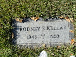
Rodney Eugene Kellar
| Birth | : | 23 Apr 1943 Chester, Liberty County, Montana, USA |
| Death | : | 30 Jul 1959 Havre, Hill County, Montana, USA |
| Burial | : | Calvary Cemetery, Havre, Hill County, USA |
| Coordinate | : | 48.5457000, -109.6883000 |
| Plot | : | Space D Lot 16 Block 16 |
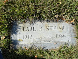
| Description | : | 7/4/2022: Suggested edit: Great Falls Tribune (MT), 1 Aug 1959 At Fresno Dam--Havre Youth Drowns as Kayak Tips Havre--Roaring Milk River water spilling down Fresno Dam flipped a kayak over Thursday night drowning Rodney Kellar, 16, a Havre schoolboy. A construction worker, Al Rankin, was also spilled into the foamy spillway, 20 miles west of Havre, but he managed to cling to the upturned Eskimo-type craft. Kellar's father, Earl, said his son was a good swimmer. Both wore jackets but their efficiency in turbulent water was questioned. Witnesses saw the craft capsize in the rough water. Both were thrown clear... Read More |
frequently asked questions (FAQ):
-
Where is Rodney Eugene Kellar's memorial?
Rodney Eugene Kellar's memorial is located at: Calvary Cemetery, Havre, Hill County, USA.
-
When did Rodney Eugene Kellar death?
Rodney Eugene Kellar death on 30 Jul 1959 in Havre, Hill County, Montana, USA
-
Where are the coordinates of the Rodney Eugene Kellar's memorial?
Latitude: 48.5457000
Longitude: -109.6883000
Family Members:
Parent
Siblings
Flowers:


Nearby Cemetories:
1. Calvary Cemetery
Havre, Hill County, USA
Coordinate: 48.5457000, -109.6883000
2. Highland Cemetery
Havre, Hill County, USA
Coordinate: 48.5463982, -109.6900024
3. Mount Hope Cemetery
Havre, Hill County, USA
Coordinate: 48.5540000, -109.7050000
4. Sunset Garden Park
Havre, Hill County, USA
Coordinate: 48.5531006, -109.8019028
5. North Havre Lutheran Church Graveyard (Defunct)
Havre, Hill County, USA
Coordinate: 48.6538903, -109.6815870
6. Grainbelt Cemetery
Hill County, USA
Coordinate: 48.6828003, -109.8657990
7. Andrew S. Lohman Grave Site
Lohman, Blaine County, USA
Coordinate: 48.5903520, -109.4073350
8. East End Colony Cemetery
East End Colony, Hill County, USA
Coordinate: 48.7485000, -109.5474000
9. Hilldale Hutterite Colony Cemetery
Hilldale Colony, Hill County, USA
Coordinate: 48.7997000, -109.7872000
10. Saint Johns Catholic Cemetery
Havre, Hill County, USA
Coordinate: 48.7625008, -109.9638977
11. Saint Gabriel Cemetery
Chinook, Blaine County, USA
Coordinate: 48.6065200, -109.2531200
12. Kuper Memorial Cemetery
Chinook, Blaine County, USA
Coordinate: 48.6083100, -109.2531200
13. Rocky Boy Cemetery
Rocky Boy, Hill County, USA
Coordinate: 48.2572410, -109.7923690
14. Box Elder Cemetery
Box Elder, Hill County, USA
Coordinate: 48.3274000, -110.0095000
15. Rocky Boy Gravel Cemetery
Rocky Boy, Hill County, USA
Coordinate: 48.2427720, -109.7596500
16. Cottonwood Lutheran Church Cemetery
Havre, Hill County, USA
Coordinate: 48.4545000, -110.1748000
17. Bear Paw Battlefield
Chinook, Blaine County, USA
Coordinate: 48.3780070, -109.2121290
18. Hungry Hollow Cemetery
Blaine County, USA
Coordinate: 48.2103004, -109.4677963
19. Milk River Valley Church Graveyard
Hill County, USA
Coordinate: 48.6787180, -110.2261080
20. Hollandville Cemetery
Chinook, Blaine County, USA
Coordinate: 48.6960310, -109.1557200
21. Gildford Hill County Cemetery
Gildford, Hill County, USA
Coordinate: 48.5778008, -110.2957993
22. Prairie Chapel United Brethren Cemetery
Chinook, Blaine County, USA
Coordinate: 48.8860000, -109.3414000
23. Mennonite Brethren Cemetery
Chinook, Blaine County, USA
Coordinate: 48.8012560, -109.1980620
24. Bethel Bruderthaler Mennonite Church Cemetery
Chinook, Blaine County, USA
Coordinate: 48.7552000, -109.1345000