

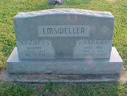
Rosa Mae Osborn Emsweller
| Birth | : | 11 Nov 1876 Franklin County, Indiana, USA |
| Death | : | 13 Jan 1950 Rush County, Indiana, USA |
| Burial | : | Spring Grove Cemetery, Cincinnati, Hamilton County, USA |
| Coordinate | : | 39.1647900, -84.5231500 |
| Description | : | Rosa Mae Osborn Emsweller OBITUARY, Connersville [IN] News-Examiner, Friday, January 13, 1950: Mrs. Rose Mae Emsweller, 73, died at 9:10 p.m. Thursday at the home of her daughter, Mrs. Melvin Miller, south of New Salem in Rush county. She had been ill for several months. Born in Franklin county November 11, 1876, a daughter of James and Elizabeth Sutton Osborn, Mrs. Emsweller resided in Indianapolis for 27 years before moving to Rush county. Her husband, William Emsweller, died in 1937. ... Read More |
frequently asked questions (FAQ):
-
Where is Rosa Mae Osborn Emsweller's memorial?
Rosa Mae Osborn Emsweller's memorial is located at: Spring Grove Cemetery, Cincinnati, Hamilton County, USA.
-
When did Rosa Mae Osborn Emsweller death?
Rosa Mae Osborn Emsweller death on 13 Jan 1950 in Rush County, Indiana, USA
-
Where are the coordinates of the Rosa Mae Osborn Emsweller's memorial?
Latitude: 39.1647900
Longitude: -84.5231500
Family Members:
Parent
Spouse
Siblings
Children

Flowers:


Nearby Cemetories:
1. Spring Grove Cemetery
Cincinnati, Hamilton County, USA
Coordinate: 39.1647900, -84.5231500
2. Saint John Cemetery
Saint Bernard, Hamilton County, USA
Coordinate: 39.1643982, -84.5053024
3. Vine Street Hill Cemetery
Cincinnati, Hamilton County, USA
Coordinate: 39.1516991, -84.5091019
4. Clifton United Jewish Cemetery
Cincinnati, Hamilton County, USA
Coordinate: 39.1470871, -84.5292816
5. Wesleyan Cemetery
Cincinnati, Hamilton County, USA
Coordinate: 39.1599998, -84.5468979
6. Third Quaker Cemetery (Defunct)
Cincinnati, Hamilton County, USA
Coordinate: 39.1542400, -84.5523720
7. Hillside Chapel Crematory and Columbarium
Cincinnati, Hamilton County, USA
Coordinate: 39.1393509, -84.5247192
8. Saint Mary Cemetery
Saint Bernard, Hamilton County, USA
Coordinate: 39.1664009, -84.4880981
9. Old Finneytown Cemetery
Finneytown, Hamilton County, USA
Coordinate: 39.1962220, -84.5206120
10. First German Protestant Cemetery
Avondale, Hamilton County, USA
Coordinate: 39.1492004, -84.4863968
11. Bishop Cemetery (Defunct)
College Hill, Hamilton County, USA
Coordinate: 39.1910210, -84.5489570
12. Methodist Protestant Cemetery (Defunct)
Cincinnati, Hamilton County, USA
Coordinate: 39.1324770, -84.4983160
13. Baltimore Pike Cemetery
Cincinnati, Hamilton County, USA
Coordinate: 39.1397018, -84.5681000
14. Convent of the Good Shepherd Cemetery (Defunct)
Carthage, Hamilton County, USA
Coordinate: 39.2055250, -84.5042780
15. Walnut Hills Cemetery
Cincinnati, Hamilton County, USA
Coordinate: 39.1355950, -84.4809040
16. Walnut Hills Jewish Cemetery
Evanston, Hamilton County, USA
Coordinate: 39.1403700, -84.4731300
17. Gard-Brown Cemetery
North Bend, Hamilton County, USA
Coordinate: 39.2035200, -84.5553300
18. Calvary Cemetery
Cincinnati, Hamilton County, USA
Coordinate: 39.1403008, -84.4697037
19. Longview Hospital Cemetery
Roselawn, Hamilton County, USA
Coordinate: 39.1887730, -84.4691660
20. Martini United Church of Christ Cemetery
Fairmount, Hamilton County, USA
Coordinate: 39.1296272, -84.5664902
21. Second Quaker Cemetery (Defunct)
Cincinnati, Hamilton County, USA
Coordinate: 39.1153090, -84.5305240
22. Christ Church Cemetery
Over-The-Rhine, Hamilton County, USA
Coordinate: 39.1126480, -84.5157623
23. Griffins Station Cemetery
Carthage, Hamilton County, USA
Coordinate: 39.2047000, -84.4770730
24. Jessup Cemetery
Mount Airy, Hamilton County, USA
Coordinate: 39.1970870, -84.5794270