

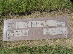
Rose Anna Elizabeth Stremcha O'Neal
| Birth | : | 27 Sep 1905 Edwardsville, Madison County, Illinois, USA |
| Death | : | 3 Feb 1992 Havre, Hill County, Montana, USA |
| Burial | : | Calvary Cemetery, Havre, Hill County, USA |
| Coordinate | : | 48.5457000, -109.6883000 |
| Plot | : | Space F, Lot 37, Block 14 |
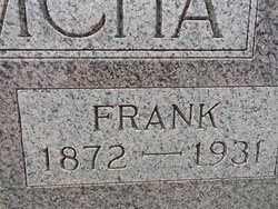
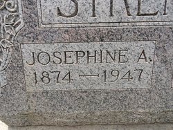
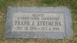
| Description | : | The following obituary has two errors: 1. Rose married Thomas O'Neal on 7 November 1925 in Havre, Montana. 2. Rose was buried in Calvary Cemetery next to her husband. Havre Daily News (MT), 3 Feb 1992 Havre--Rose A. O'Neal, 86, died early today at a Havre hospital, of natural causes. A funeral Mass will be said Wednesday at 10 a.m. at St. Jude's Catholic Church. Burial will be in Highland cemetery. Mrs. O'Neal was born Sept. 27, 1905 in Edwardsville, Ill., to Frank and Josephine Stremcha. She came to Montana as a child with her parents to homestead north of Havre. ... Read More |
frequently asked questions (FAQ):
-
Where is Rose Anna Elizabeth Stremcha O'Neal's memorial?
Rose Anna Elizabeth Stremcha O'Neal's memorial is located at: Calvary Cemetery, Havre, Hill County, USA.
-
When did Rose Anna Elizabeth Stremcha O'Neal death?
Rose Anna Elizabeth Stremcha O'Neal death on 3 Feb 1992 in Havre, Hill County, Montana, USA
-
Where are the coordinates of the Rose Anna Elizabeth Stremcha O'Neal's memorial?
Latitude: 48.5457000
Longitude: -109.6883000
Family Members:
Parent
Spouse
Siblings

Children
Flowers:


Nearby Cemetories:
1. Calvary Cemetery
Havre, Hill County, USA
Coordinate: 48.5457000, -109.6883000
2. Highland Cemetery
Havre, Hill County, USA
Coordinate: 48.5463982, -109.6900024
3. Mount Hope Cemetery
Havre, Hill County, USA
Coordinate: 48.5540000, -109.7050000
4. Sunset Garden Park
Havre, Hill County, USA
Coordinate: 48.5531006, -109.8019028
5. North Havre Lutheran Church Graveyard (Defunct)
Havre, Hill County, USA
Coordinate: 48.6538903, -109.6815870
6. Grainbelt Cemetery
Hill County, USA
Coordinate: 48.6828003, -109.8657990
7. Andrew S. Lohman Grave Site
Lohman, Blaine County, USA
Coordinate: 48.5903520, -109.4073350
8. East End Colony Cemetery
East End Colony, Hill County, USA
Coordinate: 48.7485000, -109.5474000
9. Hilldale Hutterite Colony Cemetery
Hilldale Colony, Hill County, USA
Coordinate: 48.7997000, -109.7872000
10. Saint Johns Catholic Cemetery
Havre, Hill County, USA
Coordinate: 48.7625008, -109.9638977
11. Saint Gabriel Cemetery
Chinook, Blaine County, USA
Coordinate: 48.6065200, -109.2531200
12. Kuper Memorial Cemetery
Chinook, Blaine County, USA
Coordinate: 48.6083100, -109.2531200
13. Rocky Boy Cemetery
Rocky Boy, Hill County, USA
Coordinate: 48.2572410, -109.7923690
14. Box Elder Cemetery
Box Elder, Hill County, USA
Coordinate: 48.3274000, -110.0095000
15. Rocky Boy Gravel Cemetery
Rocky Boy, Hill County, USA
Coordinate: 48.2427720, -109.7596500
16. Cottonwood Lutheran Church Cemetery
Havre, Hill County, USA
Coordinate: 48.4545000, -110.1748000
17. Bear Paw Battlefield
Chinook, Blaine County, USA
Coordinate: 48.3780070, -109.2121290
18. Hungry Hollow Cemetery
Blaine County, USA
Coordinate: 48.2103004, -109.4677963
19. Milk River Valley Church Graveyard
Hill County, USA
Coordinate: 48.6787180, -110.2261080
20. Hollandville Cemetery
Chinook, Blaine County, USA
Coordinate: 48.6960310, -109.1557200
21. Gildford Hill County Cemetery
Gildford, Hill County, USA
Coordinate: 48.5778008, -110.2957993
22. Prairie Chapel United Brethren Cemetery
Chinook, Blaine County, USA
Coordinate: 48.8860000, -109.3414000
23. Mennonite Brethren Cemetery
Chinook, Blaine County, USA
Coordinate: 48.8012560, -109.1980620
24. Bethel Bruderthaler Mennonite Church Cemetery
Chinook, Blaine County, USA
Coordinate: 48.7552000, -109.1345000