
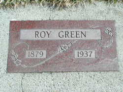
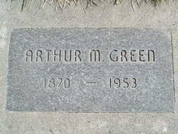
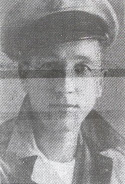
Royer Lincoln “Roy” Green
| Birth | : | 5 Jun 1879 Shelby, Shelby County, Iowa, USA |
| Death | : | 24 Feb 1937 Spokane, Spokane County, Washington, USA |
| Burial | : | Chelan Fraternal Cemetery, Chelan, Chelan County, USA |
| Coordinate | : | 47.8502998, -120.0081024 |
| Plot | : | North Fraternal Row25 BLK28 LS1 |
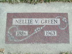
| Description | : | Friday services were held for Roy Lincoln Green. He was born June 5, 1879 at Shelby, Iowa and when a small boy moved with his parents to Sioux Co, Nebraska, where a post office was named in his honor and called "Royville.: His mother was postmistress there for some years. In 1894, with his parents, sisters and brothers, he came to Oregon where the family remained a year, thence in 1895 completing the journey to Chelan, which had remained his home until his death, February 24, at Spokane. He was married to Miss Nellie V. Pruett, Dec. 24, 1905, and to... Read More |
frequently asked questions (FAQ):
-
Where is Royer Lincoln “Roy” Green's memorial?
Royer Lincoln “Roy” Green's memorial is located at: Chelan Fraternal Cemetery, Chelan, Chelan County, USA.
-
When did Royer Lincoln “Roy” Green death?
Royer Lincoln “Roy” Green death on 24 Feb 1937 in Spokane, Spokane County, Washington, USA
-
Where are the coordinates of the Royer Lincoln “Roy” Green's memorial?
Latitude: 47.8502998
Longitude: -120.0081024
Family Members:
Parent
Spouse
Siblings
Children
Flowers:


Nearby Cemetories:
1. Chelan Fraternal Cemetery
Chelan, Chelan County, USA
Coordinate: 47.8502998, -120.0081024
2. Mount Olivet Cemetery
Chelan, Chelan County, USA
Coordinate: 47.8451000, -119.9946000
3. Saint Andrews Episcopal Church
Chelan, Chelan County, USA
Coordinate: 47.8397460, -120.0183780
4. Riverview Cemetery
Chelan, Chelan County, USA
Coordinate: 47.8335991, -119.9944000
5. Manson Indian Cemetery
Manson, Chelan County, USA
Coordinate: 47.8800000, -120.1300000
6. Ballard Family Cemetery
Stayman, Chelan County, USA
Coordinate: 47.7811100, -120.1133300
7. Fletcher Cemetery
Douglas County, USA
Coordinate: 47.7430992, -119.9403000
8. Brays Landing Cemetery
Douglas County, USA
Coordinate: 47.7364120, -120.1704660
9. Kummer Cemetery
Waterville, Douglas County, USA
Coordinate: 47.6559000, -120.0332000
10. Packwood Memorial Cemetery
Dyer, Douglas County, USA
Coordinate: 48.0118305, -119.8178880
11. Dick Family Cemetery
Okanogan County, USA
Coordinate: 48.0502700, -119.9241700
12. Miller Family Cemetery
Okanogan County, USA
Coordinate: 48.0530300, -119.9288000
13. Pateros Cemetery
Pateros, Okanogan County, USA
Coordinate: 48.0516600, -119.9097300
14. Waterville Cemetery
Waterville, Douglas County, USA
Coordinate: 47.6418500, -120.0685940
15. Gate of Heaven Catholic Cemetery
Waterville, Douglas County, USA
Coordinate: 47.6382100, -120.0671690
16. Douglas Lutheran Cemetery
Douglas County, USA
Coordinate: 47.6189003, -119.9614029
17. Badger Mountain View Cemetery
Douglas County, USA
Coordinate: 47.6088000, -120.0476000
18. Mansfield Cemetery
Mansfield, Douglas County, USA
Coordinate: 47.8088880, -119.6508330
19. Orondo Community Cemetery
Orondo, Douglas County, USA
Coordinate: 47.6486015, -120.2136002
20. Buckingham Cemetery
Douglas County, USA
Coordinate: 47.8669014, -119.6286011
21. Happy Home Cemetery
Farmer, Douglas County, USA
Coordinate: 47.6268997, -119.8125000
22. Methow Cemetery
Methow, Okanogan County, USA
Coordinate: 48.1102982, -120.0124969
23. Entiat Cemetery
Entiat, Chelan County, USA
Coordinate: 47.6755981, -120.3043976
24. Bridgeport Cemetery
Bridgeport, Douglas County, USA
Coordinate: 48.0050000, -119.6738800