
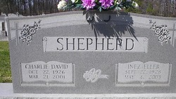

Ruby Inez Eller Shepherd
| Birth | : | 22 Sep 1928 Rowan County, North Carolina, USA |
| Death | : | 4 May 2003 Salisbury, Rowan County, North Carolina, USA |
| Burial | : | Sugar Grove Cemetery, Sugar Grove, Fairfield County, USA |
| Coordinate | : | 39.6203003, -82.5436020 |
| Plot | : | Row 22 |
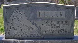
| Description | : | Inez Eller Shepherd, 74, Salisbury, died Sunday (May 4, 2003) at Autumn Care of Salisbury. Born Sept. 22, 1928, in Rowan County, Mrs. Shepherd was a daughter of the late Lee and Jennie Loudara Lemly Eller. She was educated in the Rowan County schools. Formerly employed as cafeteria manager at Morgan School, she retired from Lyon-Shaw Corporation. She was a life member of St. Matthew's Lutheran Church, where she was involved with WELCA, the Seniors Sunday School Class, the choir and taught in the preschool Sunday school class for 42 years. She was a member of Liberty Home Demonstration Club. Her husband, Charlie... Read More |
frequently asked questions (FAQ):
-
Where is Ruby Inez Eller Shepherd's memorial?
Ruby Inez Eller Shepherd's memorial is located at: Sugar Grove Cemetery, Sugar Grove, Fairfield County, USA.
-
When did Ruby Inez Eller Shepherd death?
Ruby Inez Eller Shepherd death on 4 May 2003 in Salisbury, Rowan County, North Carolina, USA
-
Where are the coordinates of the Ruby Inez Eller Shepherd's memorial?
Latitude: 39.6203003
Longitude: -82.5436020
Family Members:
Parent

Spouse

Siblings

Flowers:


Nearby Cemetories:
1. Sugar Grove Cemetery
Sugar Grove, Fairfield County, USA
Coordinate: 39.6203003, -82.5436020
2. Evangelical Lutheran Cemetery
Sugar Grove, Fairfield County, USA
Coordinate: 39.6211761, -82.5423817
3. Sharp Cemetery
Sugar Grove, Fairfield County, USA
Coordinate: 39.6203003, -82.5535965
4. Stukey Cemetery
Fairfield County, USA
Coordinate: 39.6343994, -82.5558014
5. Ream Cemetery
Sugar Grove, Fairfield County, USA
Coordinate: 39.6513610, -82.5546500
6. Brushy Fork Cemetery
Sugar Grove, Fairfield County, USA
Coordinate: 39.6150017, -82.5871964
7. Trinity Sponagle Lutheran Church Cemetery
Sugar Grove, Fairfield County, USA
Coordinate: 39.6159600, -82.4993000
8. Richards Family Cemetery
Rockbridge, Hocking County, USA
Coordinate: 39.5853680, -82.5390430
9. Phillips Cemetery
Horns Mill, Fairfield County, USA
Coordinate: 39.6475640, -82.5144030
10. Union Grove Cemetery
Rockbridge, Hocking County, USA
Coordinate: 39.5776520, -82.5558070
11. Union Church Cemetery
Good Hope Township, Hocking County, USA
Coordinate: 39.5774498, -82.5608368
12. Our Lady of Good Hope Catholic Cemetery
Good Hope Township, Hocking County, USA
Coordinate: 39.6036797, -82.6033020
13. Whippoorwill Cemetery
Good Hope Township, Hocking County, USA
Coordinate: 39.5677986, -82.5430984
14. Tarkiln Cemetery
Berne Township, Fairfield County, USA
Coordinate: 39.6653000, -82.5842240
15. Centenary Cemetery
Enterprise, Hocking County, USA
Coordinate: 39.5802994, -82.4946976
16. Pleasant Hill Cemetery
Berne Township, Fairfield County, USA
Coordinate: 39.6717239, -82.5084873
17. Crawfis-Emery Cemetery
Lancaster, Fairfield County, USA
Coordinate: 39.6787000, -82.5580000
18. Baron-Graham Family Cemetery
Hideaway Hills, Hocking County, USA
Coordinate: 39.6385070, -82.4657110
19. Saint Emanuel Lutheran Cemetery
Marion Township, Hocking County, USA
Coordinate: 39.6433900, -82.4628000
20. Dawley Wood Cemetery
Enterprise, Hocking County, USA
Coordinate: 39.5731670, -82.4818100
21. Fairfield School For Boys Cemetery
Lancaster, Fairfield County, USA
Coordinate: 39.6447301, -82.6249481
22. Saint Jacobus Evangelical Lutheran Cemetery
Hideaway Hills, Hocking County, USA
Coordinate: 39.6434700, -82.4607900
23. Fairview Memorial Gardens
Rockbridge, Hocking County, USA
Coordinate: 39.5594510, -82.5028920
24. Kline Cemetery
Good Hope Township, Hocking County, USA
Coordinate: 39.5588070, -82.5035510