

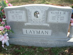
Ruby Maxine Glenn Layman
| Birth | : | 29 Dec 1932 |
| Death | : | 15 Nov 2012 |
| Burial | : | New Hope United Methodist Church Cemetery, Millville, Ray County, USA |
| Coordinate | : | 39.4236259, -93.8416061 |
| Description | : | Ruby Maxine Layman, 79, of Hardin, Missouri, died Thursday, November 15, 2012 at North Kansas City Hospital, North Kansas City, Missouri. Maxine was born on December 29, 1932 in Edmond, Oklahoma, to William Ferman and Donnie (Simpson) Glenn. She married Walter K. "Junior" Layman of Hardin on August 22, 1953; he survives of the home. Maxine was a housewife and homemaker. She was a member of the Liberty Church of Christ in Norborne before transferring to the Church of Christ in Braymer, Missouri. She was also a member of the Russellville Extension Club. Maxine lived north of... Read More |
frequently asked questions (FAQ):
-
Where is Ruby Maxine Glenn Layman's memorial?
Ruby Maxine Glenn Layman's memorial is located at: New Hope United Methodist Church Cemetery, Millville, Ray County, USA.
-
When did Ruby Maxine Glenn Layman death?
Ruby Maxine Glenn Layman death on 15 Nov 2012 in
-
Where are the coordinates of the Ruby Maxine Glenn Layman's memorial?
Latitude: 39.4236259
Longitude: -93.8416061
Family Members:
Spouse
Children
Flowers:


Nearby Cemetories:
1. New Hope United Methodist Church Cemetery
Millville, Ray County, USA
Coordinate: 39.4236259, -93.8416061
2. Old New Hope Cemetery
Millville, Ray County, USA
Coordinate: 39.4327200, -93.8435900
3. McCuistion Cemetery
Richmond, Ray County, USA
Coordinate: 39.4387300, -93.8550900
4. Silas Keith Cemetery
Regal, Ray County, USA
Coordinate: 39.4387800, -93.8262100
5. Mansur Cemetery
Grape Grove Township, Ray County, USA
Coordinate: 39.4230003, -93.8804016
6. Carleton Cemetery
Ray County, USA
Coordinate: 39.4014200, -93.8712700
7. Smith Cemetery
Ray County, USA
Coordinate: 39.4028015, -93.8799973
8. Berry Cemetery
Hardin, Ray County, USA
Coordinate: 39.3913800, -93.8710800
9. Nuckles Cemetery
Richmond, Ray County, USA
Coordinate: 39.4143700, -93.8950300
10. Bethany Church Cemetery
Stet, Ray County, USA
Coordinate: 39.4230995, -93.7838974
11. Woolard Cemetery
Hardin, Ray County, USA
Coordinate: 39.3769300, -93.8351500
12. Felix Wild Cemetery
Ray County, USA
Coordinate: 39.4398200, -93.9110700
13. Antioch Cemetery
Millville, Ray County, USA
Coordinate: 39.4563040, -93.9077420
14. Van Wall Cemetery
Grape Grove Township, Ray County, USA
Coordinate: 39.4513800, -93.9116700
15. Moyer Cemetery
Ray County, USA
Coordinate: 39.4244100, -93.9224100
16. Graff Cemetery
Grape Grove Township, Ray County, USA
Coordinate: 39.4909286, -93.8144836
17. Wakenda Cemetery
Hardin, Ray County, USA
Coordinate: 39.3519300, -93.8456900
18. Meinking-Wilson Cemetery
Ray County, USA
Coordinate: 39.3576200, -93.7995600
19. Millville Community Cemetery
Millville, Ray County, USA
Coordinate: 39.4041100, -93.9351600
20. Little Union Cemetery
Stet, Ray County, USA
Coordinate: 39.4972343, -93.8660507
21. Bethel Mennonite Church Cemetery
Richmond, Ray County, USA
Coordinate: 39.3936900, -93.9330400
22. Basham Cemetery
Ray County, USA
Coordinate: 39.4963400, -93.8810700
23. Mount Olivet Cemetery
Stet, Carroll County, USA
Coordinate: 39.4366000, -93.7403000
24. Elder Cemetery
Grape Grove Township, Ray County, USA
Coordinate: 39.5015259, -93.8108826