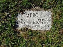
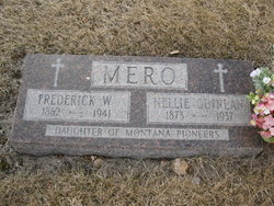
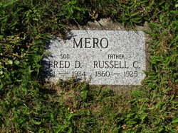
Russell Clark Mero
| Birth | : | 25 Nov 1860 Livingston, Grant County, Wisconsin, USA |
| Death | : | 2 May 1925 Mason County, Washington, USA |
| Burial | : | Alexandria Cemetery, Alexandria, Campbell County, USA |
| Coordinate | : | 38.9536100, -84.3972300 |
| Plot | : | SCA, 4 3 H |
| Description | : | Russell Clark Mero, son of Frederick and Delilah (Adkins) Mero, was born in 1860 and died in 1925. His father died in 1863 on a hospital boat on the way to St. Louis, during the Civil War. (His mother remarried later to Ellis Greenhalgh.) Russell married Alma Mina Alfarette Latham on Sept. 5, 1880, in Grant County, Wisconsin, where they lived until they moved to Washington State. They had six children, all born in Wisconsin: Frederick D., David Depew, Annie Augusta, Laura C., Archie Roscoe, and Dorothy. Alma died in 1922 at their daughter, Dorothy's, in NY State. Russell died in Washington State... Read More |
frequently asked questions (FAQ):
-
Where is Russell Clark Mero's memorial?
Russell Clark Mero's memorial is located at: Alexandria Cemetery, Alexandria, Campbell County, USA.
-
When did Russell Clark Mero death?
Russell Clark Mero death on 2 May 1925 in Mason County, Washington, USA
-
Where are the coordinates of the Russell Clark Mero's memorial?
Latitude: 38.9536100
Longitude: -84.3972300
Family Members:
Parent
Spouse
Siblings
Children
Flowers:
Nearby Cemetories:
1. Alexandria Cemetery
Alexandria, Campbell County, USA
Coordinate: 38.9536100, -84.3972300
2. Saint Mary's Cemetery
Alexandria, Campbell County, USA
Coordinate: 38.9559100, -84.3877800
3. Saint Paul's Church Cemetery
Alexandria, Campbell County, USA
Coordinate: 38.9582720, -84.3877080
4. Old Baptist Cemetery
Alexandria, Campbell County, USA
Coordinate: 38.9603890, -84.3880590
5. Boyles Maxwell Family Cemetery
Alexandria, Campbell County, USA
Coordinate: 38.9553900, -84.3804900
6. Thatcher Family Cemetery
Campbell County, USA
Coordinate: 38.9665480, -84.3935800
7. Robert Shaw Family Cemetery
Alexandria, Campbell County, USA
Coordinate: 38.9623330, -84.3635670
8. Grant Family Cemetery
Grant, Kenton County, USA
Coordinate: 38.9743710, -84.4326160
9. Stephens Farm Cemetery
Alexandria, Campbell County, USA
Coordinate: 38.9566350, -84.3528650
10. Stamper Family Cemetery
Grant, Kenton County, USA
Coordinate: 38.9746130, -84.4338000
11. Weinel Family Graveyard
Claryville, Campbell County, USA
Coordinate: 38.9181780, -84.4245220
12. Kuhl Farm Cemetery
Claryville, Campbell County, USA
Coordinate: 38.9108330, -84.4064840
13. White Cemetery
Ryland Heights, Kenton County, USA
Coordinate: 38.9625000, -84.4583330
14. Saint Josephs Cemetery
Camp Springs, Campbell County, USA
Coordinate: 38.9953570, -84.3625520
15. White Cemetery
Ryland Heights, Kenton County, USA
Coordinate: 38.9628600, -84.4642900
16. Notley Maddox Cemetery
Claryville, Campbell County, USA
Coordinate: 38.9094450, -84.4375010
17. Carmack Cemetery
Carthage, Campbell County, USA
Coordinate: 38.9582510, -84.3272630
18. Willard Neal Farm Cemetery
Alexandria, Campbell County, USA
Coordinate: 38.9571660, -84.3254490
19. Notley Maddox Slave Cemetery
Claryville, Campbell County, USA
Coordinate: 38.9083320, -84.4394440
20. Cherry Family Cemetery
Persimmon Grove, Campbell County, USA
Coordinate: 38.9101700, -84.3451110
21. Pleasant Ridge Baptist Church Cemetery
Grants Lick, Campbell County, USA
Coordinate: 38.8949400, -84.4158200
22. Saint John Lutheran Church Cemetery
Camp Springs, Campbell County, USA
Coordinate: 39.0144150, -84.3826140
23. John Byrd Cemetery
Aspen Grove, Campbell County, USA
Coordinate: 38.8916990, -84.4032690
24. Winston Cemetery
Kenton, Kenton County, USA
Coordinate: 38.9030560, -84.4438890


