
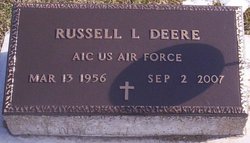
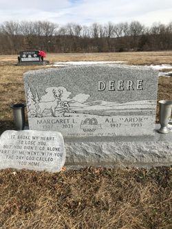
Russell L. Deere
| Birth | : | 13 Mar 1956 |
| Death | : | 2 Sep 2007 |
| Burial | : | Woodlands Cemetery and Crematorium, Scarborough, Scarborough Borough, England |
| Coordinate | : | 54.2766640, -0.4428030 |
| Description | : | Russell L. Deere, 51, of Marshalltown died at 2:18 a.m. Sunday, Sept. 2, 2007, at Iowa Veterans Home in Marshalltown. Born March 13, 1956, in Keokuk, he was the son of Ardath L. and Margaret L. Evans Deere. On Nov. 7, 1987, he married Ellen Manley in Kansas City, Mo. They divorced in 1996. Mr. Deere was a veteran of the Air Force and a 1974 graduate of Harmony High School. He was a member of First Baptist Church in Farmington. He enjoyed bluegrass music and playing guitar. Survivors include three daughters, Lauren Deere, Lucy Deere and Chelsea Deere, all of Kansas... Read More |
frequently asked questions (FAQ):
-
Where is Russell L. Deere's memorial?
Russell L. Deere's memorial is located at: Woodlands Cemetery and Crematorium, Scarborough, Scarborough Borough, England.
-
When did Russell L. Deere death?
Russell L. Deere death on 2 Sep 2007 in
-
Where are the coordinates of the Russell L. Deere's memorial?
Latitude: 54.2766640
Longitude: -0.4428030
Family Members:
Parent
Siblings
Flowers:


Nearby Cemetories:
1. Woodlands Cemetery and Crematorium
Scarborough, Scarborough Borough, England
Coordinate: 54.2766640, -0.4428030
2. Dean Road and Manor Road Cemetery
Scarborough, Scarborough Borough, England
Coordinate: 54.2843690, -0.4184140
3. St Laurence Churchyard
Scalby, Scarborough Borough, England
Coordinate: 54.2988160, -0.4507520
4. Greyfriars Abbey
Scarborough, Scarborough Borough, England
Coordinate: 54.2850360, -0.3950300
5. Quaker House Church
Scarborough Borough, England
Coordinate: 54.2844280, -0.3941730
6. St. Mary's Churchyard
Scarborough, Scarborough Borough, England
Coordinate: 54.2864850, -0.3936260
7. Scarborough Castle
Scarborough, Scarborough Borough, England
Coordinate: 54.2875810, -0.3895485
8. St. John the Baptist Churchyard
East Ayton, Scarborough Borough, England
Coordinate: 54.2508900, -0.4792900
9. St Martin Churchyard
Seamer, Scarborough Borough, England
Coordinate: 54.2361500, -0.4437100
10. St Peter Churchyard
Hackness, Scarborough Borough, England
Coordinate: 54.3012880, -0.5127850
11. St Matthew Churchyard
Hutton Buscel, Scarborough Borough, England
Coordinate: 54.2426410, -0.5071200
12. St. John the Baptist Churchyard
Cayton, Scarborough Borough, England
Coordinate: 54.2346470, -0.3805180
13. Cloughton Church Cemetery
Cloughton, Scarborough Borough, England
Coordinate: 54.3322500, -0.4511900
14. Cayton Cemetery
Cayton, Scarborough Borough, England
Coordinate: 54.2314030, -0.3755910
15. St. Helen’s & All Saints Churchyard
Wykeham, Scarborough Borough, England
Coordinate: 54.2372000, -0.5212000
16. St Peter Churchyard
Langdale End, Scarborough Borough, England
Coordinate: 54.3065050, -0.5557030
17. St. Peter's Churchyard
Willerby, Ryedale District, England
Coordinate: 54.1984200, -0.4558500
18. Flixton Cemetery New
Folkton, Scarborough Borough, England
Coordinate: 54.2006600, -0.3934700
19. St John The Evangelist Churchyard
Folkton, Scarborough Borough, England
Coordinate: 54.2020400, -0.3865200
20. All Saints Churchyard
Brompton-by-Sawdon, Scarborough Borough, England
Coordinate: 54.2262550, -0.5549320
21. All Saints Church Cemetery
Brompton-by-Sawdon, Scarborough Borough, England
Coordinate: 54.2223100, -0.5500900
22. St Margaret Churchyard
Harwood Dale, Scarborough Borough, England
Coordinate: 54.3470030, -0.5238540
23. St Nicholas Churchyard
Ganton, Ryedale District, England
Coordinate: 54.1846000, -0.4846000
24. St Margaret Churchyard (Ruins)
Harwood Dale, Scarborough Borough, England
Coordinate: 54.3558170, -0.5365790