
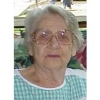
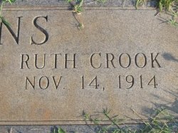
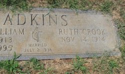
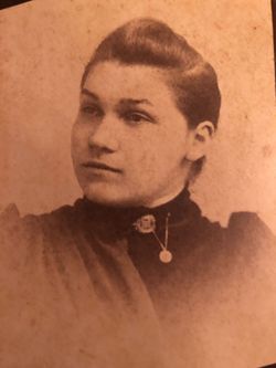
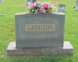
Ruth London Crook Adkins
| Birth | : | 14 Nov 1914 Fort Mill, York County, South Carolina, USA |
| Death | : | 8 Feb 2010 Fort Mill, York County, South Carolina, USA |
| Burial | : | All Saints Churchyard, Flore, Daventry District, England |
| Coordinate | : | 52.2331000, -1.0615000 |
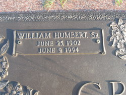
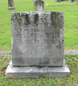
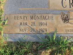
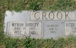
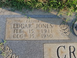
| Description | : | ..Married July 2, 1936. ..Obit: The Herald. FORT MILL - Mrs. Ruth London Crook Adkins, 95, died Monday, Feb. 8, 2010, at her home, where she was born and lived her entire life. The funeral will be at 2 p.m. Friday, Feb. 12, 2010, at Philadelphia United Methodist Church, with the Rev. Kevin Cooley officiating. Burial will be at the church cemetery. Born in Fort Mill, Mrs. Adkins was a daughter of the late William Henry Montague Crook and Jennie Jones Crook. She was a graduate of Fort Mill High School Class of 1931 and also Winthrop College Class of 1935. Mrs. Adkins was... Read More |
frequently asked questions (FAQ):
-
Where is Ruth London Crook Adkins's memorial?
Ruth London Crook Adkins's memorial is located at: All Saints Churchyard, Flore, Daventry District, England.
-
When did Ruth London Crook Adkins death?
Ruth London Crook Adkins death on 8 Feb 2010 in Fort Mill, York County, South Carolina, USA
-
Where are the coordinates of the Ruth London Crook Adkins's memorial?
Latitude: 52.2331000
Longitude: -1.0615000
Family Members:
Parent
Spouse
Siblings
Flowers:


Nearby Cemetories:
1. All Saints Churchyard
Flore, Daventry District, England
Coordinate: 52.2331000, -1.0615000
2. Weedon Bec Cemetery
Weedon Bec, Daventry District, England
Coordinate: 52.2275500, -1.0715300
3. St. Peter & St. Paul's Churchyard
Weedon Bec, Daventry District, England
Coordinate: 52.2281180, -1.0741343
4. United Reformed Churchyard
Weedon Bec, Daventry District, England
Coordinate: 52.2278000, -1.0776000
5. Nether Heyford Cemetery
Nether Heyford, South Northamptonshire Borough, England
Coordinate: 52.2220715, -1.0385032
6. St Michael's Church
Stowe Nine Churches, Daventry District, England
Coordinate: 52.2120000, -1.0721000
7. St Mary the Virgin Churchyard
Dodford, Daventry District, England
Coordinate: 52.2396800, -1.1044500
8. St Michael & All Angels Churchyard
Bugbrooke, South Northamptonshire Borough, England
Coordinate: 52.2096900, -1.0149000
9. St. Andrew Churchyard
Whilton, Daventry District, England
Coordinate: 52.2776040, -1.0683450
10. All Saints Churchyard
Harpole, South Northamptonshire Borough, England
Coordinate: 52.2427100, -0.9899750
11. Everdon Parish CHurchyard
Everdon, Daventry District, England
Coordinate: 52.2123168, -1.1310740
12. All Saints Churchyard
Norton, Daventry District, England
Coordinate: 52.2681250, -1.1180030
13. St. Luke Churchyard
Kislingbury, South Northamptonshire Borough, England
Coordinate: 52.2307300, -0.9806300
14. St. Mary the Virgin
Farthingstone, Daventry District, England
Coordinate: 52.1899123, -1.1043480
15. St Mary the Virgin with St John Churchyard
Great Brington, Daventry District, England
Coordinate: 52.2810470, -1.0235660
16. Church of the Holy Cross
Pattishall, South Northamptonshire Borough, England
Coordinate: 52.1828670, -1.0197770
17. St. Luke's Churchyard
Cold Higham, South Northamptonshire Borough, England
Coordinate: 52.1759000, -1.0323000
18. Welton Road Daventry
Daventry, Daventry District, England
Coordinate: 52.2643510, -1.1590460
19. Spencer Estate Grounds
Althorp, Daventry District, England
Coordinate: 52.2839190, -0.9889520
20. St Michael's Churchyard
Upton, Northampton Borough, England
Coordinate: 52.2356600, -0.9508160
21. Rothersthorpe Extension
Rothersthorpe, South Northamptonshire Borough, England
Coordinate: 52.2046235, -0.9591382
22. United Reformed Churchyard
Long Buckby, Daventry District, England
Coordinate: 52.3016430, -1.0793930
23. Long Buckby & Brington Baptist Church
Long Buckby, Daventry District, England
Coordinate: 52.3022756, -1.0804149
24. St Peter and St Paul
Rothersthorpe, South Northamptonshire Borough, England
Coordinate: 52.2034651, -0.9566385