
| Birth | : | 10 Jan 1895 Frederick County, Maryland, USA |
| Death | : | 3 Sep 1959 Hagerstown, Washington County, Maryland, USA |
| Burial | : | All Saints Churchyard, Old Buckenham, Breckland Borough, England |
| Coordinate | : | 52.4816260, 1.0433160 |
| Inscription | : | wife of Samuel A. |
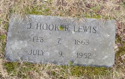
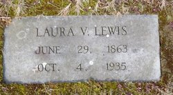
| Description | : | Sadah Rae Lewis was born January 10, 1895, in Frederick County, Maryland, daughter of Joseph Hooker and Laura Virginia Kelbaugh Lewis. On February 6, 1912, in Frederick County, she married Samuel Allen Long, son of William Henry and Sarah Elizabeth Fisher Long. They were the parents of 12 children: Roland Clyde, Roy Allen, Mary Virginia, Betty Raye, Hilda Blanche, Helen Frances, Stanley Lewis, Margaret Madeline, Shirley Elizabeth, Nancy Lee, Joyce Marie and David William Long. Sadah passed away September 3, 1959, in Hagerstown, Washington County, Maryland, and was buried on the 6th in Creagerstown Cemetery, Creagerstown,... Read More |
frequently asked questions (FAQ):
-
Where is Sadah Rae Lewis Long's memorial?
Sadah Rae Lewis Long's memorial is located at: All Saints Churchyard, Old Buckenham, Breckland Borough, England.
-
When did Sadah Rae Lewis Long death?
Sadah Rae Lewis Long death on 3 Sep 1959 in Hagerstown, Washington County, Maryland, USA
-
Where are the coordinates of the Sadah Rae Lewis Long's memorial?
Latitude: 52.4816260
Longitude: 1.0433160
Family Members:
Parent
Spouse

Siblings
Children
Flowers:


Nearby Cemetories:
1. All Saints Churchyard
Old Buckenham, Breckland Borough, England
Coordinate: 52.4816260, 1.0433160
2. Buckenham Priory
Buckenham, Broadland District, England
Coordinate: 52.4911000, 1.0497000
3. St. Martin's Churchyard
New Buckenham, Breckland Borough, England
Coordinate: 52.4728860, 1.0728380
4. Theddingworth Congregational Church yard
Theddingworth, Harborough District, England
Coordinate: 52.4644400, 1.0211700
5. St Mary's Churchyard Extension
Banham, Breckland Borough, England
Coordinate: 52.4549400, 1.0274400
6. St. Mary the Virgin Churchyard
Banham, Breckland Borough, England
Coordinate: 52.4529230, 1.0353120
7. All Saints Churchyard
Besthorpe, Breckland Borough, England
Coordinate: 52.5192800, 1.0431370
8. Parkside Garden
Attleborough, Breckland Borough, England
Coordinate: 52.5167420, 1.0209100
9. Blessed Virgin Mary Churchyard
Attleborough, Breckland Borough, England
Coordinate: 52.5178950, 1.0181880
10. Attleborough Cemetery
Attleborough, Breckland Borough, England
Coordinate: 52.5206640, 1.0157790
11. All Saints Churchyard Hargham
Quideham, Breckland Borough, England
Coordinate: 52.4826470, 0.9732300
12. All Saints Churchyard
Carleton Rode, South Norfolk District, England
Coordinate: 52.4892230, 1.1133590
13. Carmelite Monastery Cemetery
Quideham, Breckland Borough, England
Coordinate: 52.4498000, 0.9894000
14. St. Mary the Virgin Churchyard
Eccles, Breckland Borough, England
Coordinate: 52.4649373, 0.9707904
15. Carleton Rode Baptist Churchyard
Carleton Rode, South Norfolk District, England
Coordinate: 52.4937320, 1.1185210
16. St Andrews Churchyard
Quideham, Breckland Borough, England
Coordinate: 52.4493470, 0.9835550
17. St. Michael and All Angels Churchyard
Bunwell, South Norfolk District, England
Coordinate: 52.4914460, 1.1296800
18. The Chapel Graveyard
Kenninghall, Breckland Borough, England
Coordinate: 52.4359530, 0.9961130
19. Saint Mary Churchyard
Kenninghall, Breckland Borough, England
Coordinate: 52.4336980, 1.0010730
20. St. Peter's Chapel
Morley Saint Botolph, South Norfolk District, England
Coordinate: 52.5464700, 1.0416520
21. All Saints Churchyard
Snetterton, Breckland Borough, England
Coordinate: 52.4807600, 0.9350140
22. St. James Churchyard
Great Ellingham, Breckland Borough, England
Coordinate: 52.5347590, 0.9774180
23. Methodist Churchyard
Forncett End, South Norfolk District, England
Coordinate: 52.4993440, 1.1545110
24. St. Peter & St. Paul Churchyard
Shropham, Breckland Borough, England
Coordinate: 52.4968770, 0.9217990